Crécy-Couvé
| Crécy-Couvé | ||
|---|---|---|
 |
| |
| Staat | Frankreich | |
| Region | Centre-Val de Loire | |
| Département (Nr.) | Eure-et-Loir (28) | |
| Arrondissement | Dreux | |
| Kanton | Dreux-1 | |
| Gemeindeverband | Agglo du Pays de Dreux | |
| Koordinaten | 48° 40′ N, 1° 17′ O48.6697222222221.2822222222222Koordinaten: 48° 40′ N, 1° 17′ O | |
| Höhe | 107–166 m | |
| Fläche | 6,65 km² | |
| Einwohner | 270 (1. Januar 2021) | |
| Bevölkerungsdichte | 41 Einw./km² | |
| Postleitzahl | 28500 | |
| INSEE-Code | 28117 | |


Crécy-Couvé ist eine französische Gemeinde mit 270 Einwohnern (Stand: 1. Januar 2021) im Département Eure-et-Loir in der Region Centre-Val de Loire; sie gehört zum Arrondissement Dreux und zum Kanton Dreux-1.
Geographie
Crécy-Couvé liegt etwa sieben Kilometer südwestlich des Stadtzentrums von Dreux. Die Blaise begrenzt die Gemeinde im Südosten. Umgeben wird Crécy-Couvé von den Nachbargemeinden Garancières-en-Drouais im Nordwesten und Norden, Tréon im Osten, Aunay-sous-Crécy im Osten und Südosten sowie Saulnières im Süden und Westen.
Bevölkerungsentwicklung
| Jahr | 1962 | 1968 | 1975 | 1982 | 1990 | 1999 | 2006 | 2013 | 2020 |
| Einwohner | 298 | 259 | 279 | 262 | 316 | 281 | 278 | 255 | 266 |
| Quellen: Cassini und INSEE | |||||||||
Sehenswürdigkeiten
- Kirche Saint-Éloi-Saint-Jean-Baptiste, Monument historique seit 1992
- Schloss Crécy
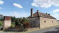
- Mühle La Bellassière, Monument historique
- Brücke La Bellassière, Monument historique
- Justizvollzugsanstalt, Monument historique
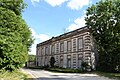
- Hospital Saint-Jean, Monument historique
- ehemalige hydraulische Maschine
-
 Kirche Saint-Éloi-Saint-Jean-Baptiste
 -
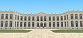 Schloss Crécy
 -
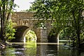 Brücke La Bellassière
 -
 Mühle La Bellassière
 -
 Justizvollzugsanstalt
 -
 Hospital Saint-Jean
 -
 Ehemaliges Maschinenhaus der hydraulischen Anlage zur Wasserversorgung


Weblinks
Commons: Crécy-Couvé – Sammlung von Bildern


