Liste der Einträge im National Register of Historic Places im Umatilla County
Diese Liste der Einträge im National Register of Historic Places im Douglas County enthält alle im Umatilla County, Oregon in das National Register of Historic Places eingetragenen Gebäude, Bauwerke, Objekte, Stätten oder historischen Distrikte.
- Diese Liste entspricht dem Bearbeitungsstand des National Park Service/National Register of Historic Places vom 21. Oktober 2016.[1]
Aktuelle Auflistung
| [2] | Name | Bild | Eintragsdatum | Lage | Ort | Beschreibung |
|---|---|---|---|---|---|---|
| 1 | Adams Odd Fellows Hall |  | 5. Aug. 1994 ID-Nr. 94000810 | 190 Main St. 45° 46′ 2,9″ N, 118° 33′ 48″ W45.76746667-118.5633278 | Adams | |
| 2 | Arlington Hotel |  | 28. Aug. 1997 ID-Nr. 97000897 | 131 W. Main St. 45° 44′ 33″ N, 119° 11′ 43″ W45.7425-119.195278 | Echo | |
| 3 | Bank of Echo Building |  | 15. Apr. 1982 ID-Nr. 82003747 | 230 W. Main St. 45° 44′ 33″ N, 119° 11′ 39″ W45.7425-119.194167 | Echo | |
| 4 | Bowman Hotel |  | 6. Nov. 1980 ID-Nr. 80003381 | 17 SW Frazer Ave. 45° 40′ 11,8″ N, 118° 47′ 11″ W45.669936-118.786398 | Pendleton | |
| 5 | Central School |  | 20. Okt. 2010 ID-Nr. 10000849 | 306 SW 2nd Ave. 45° 55′ 59″ N, 118° 23′ 26″ W45.933056-118.390556 | Milton-Freewater | |
| 6 | William J. and Lodema Clarke House | 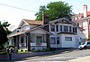 | 13. Juni 1997 ID-Nr. 97000576 | 203 NW Despain Ave. 45° 40′ 29,5″ N, 118° 47′ 22,1″ W45.674868-118.789485 | Pendleton | |
| 7 | Columbia College |  | 21. Jan. 2004 ID-Nr. 03001481 | 722 S. Main St. 45° 55′ 43,4″ N, 118° 23′ 7,1″ W45.928717-118.385292 | Milton-Freewater | |
| 8 | Joseph Cunha Farmstead |  | 28. Aug. 1997 ID-Nr. 97000898 | 33263 Oregon Trail Rd. 45° 44′ 29″ N, 119° 12′ 5″ W45.741389-119.201389 | Echo | |
| 9 | Echo City Hall |  | 28. Aug. 1997 ID-Nr. 97000899 | 20 S. Bonanza St. 45° 44′ 31″ N, 119° 11′ 39″ W45.741944-119.194167 | Echo | |
| 10 | Echo Methodist Church |  | 28. Aug. 1997 ID-Nr. 97000900 | 1 N. Bonanza St. 45° 44′ 34,2″ N, 119° 11′ 41,4″ W45.74282-119.194839 | Echo | ursprünglich erbaut 1886 im Stil der New England Vernacular architecture und 1910 umgestaltet zum neugotischen Stil.[3] |
| 11 | James Edwards Building | 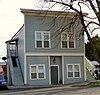 | 28. Aug. 1997 ID-Nr. 97000901 | 320 W. Main St. 45° 44′ 32″ N, 119° 11′ 34″ W45.742222-119.192778 | Echo | |
| 12 | Ellis–Hampton House | 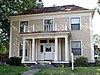 | 23. Okt. 1986 ID-Nr. 86002909 | 711 SE Byers Ave. 45° 40′ 31,2″ N, 118° 46′ 47,9″ W45.675324-118.779983 | Pendleton | |
| 13 | Empire Block | 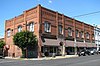 weitere Bilder | 1. Juni 1982 ID-Nr. 82003748 | 21–37 SW Emigrant Ave. 45° 40′ 14″ N, 118° 47′ 13,2″ W45.670563-118.787007 | Pendleton | |
| 14 | Williams Frazier Farmstead |  weitere Bilder | 5. Juni 1986 ID-Nr. 86001234 | 1403 Chestnut St. 45° 55′ 24″ N, 118° 22′ 36″ W45.923333-118.376667 | Milton-Freewater | |
| 15 | Greasewood Finnish Apostolic Lutheran Church |  | 14. Juli 1988 ID-Nr. 88001041 | Finn Rd. nahe der Finland Cemetery Rd. 45° 46′ 32″ N, 118° 39′ 47″ W45.775556-118.663056 | Adams | |
| 16 | Hamley and Company Leather Goods Store |  weitere Bilder | 9. Juni 1982 ID-Nr. 82003749 | 30 SE Court Ave. 45° 40′ 21,7″ N, 118° 47′ 11,8″ W45.672683-118.786613 | Pendleton | |
| 17 | Hendricks Building (K.O.T.M.) |  | 1. Juni 1982 ID-Nr. 82003750 | 369 S. Main St. 45° 40′ 14,3″ N, 118° 47′ 11,9″ W45.670652-118.786627 | Pendleton | |
| 18 | Sarah E. Ireland House | 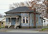 | 21. Jan. 1994 ID-Nr. 93001500 | 311 S. Main St. 45° 55′ 56″ N, 118° 23′ 10″ W45.932222-118.386111 | Milton-Freewater | |
| 19 | Johnson–Ellis House | 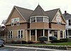 | 14. März 1986 ID-Nr. 86000347 | 326 SE 2nd St. 45° 40′ 18,9″ N, 118° 47′ 4″ W45.671923-118.784454 | Pendleton | |
| 20 | J. H. Koontz Building | 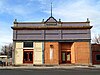 | 28. Aug. 1997 ID-Nr. 97000902 | 111 W. Main St. 45° 44′ 33″ N, 119° 11′ 44″ W45.7425-119.195556 | Echo | |
| 21 | James H. and Cynthia Koontz House |  | 28. Aug. 1997 ID-Nr. 97000903 | 210 N. Dupont St. 45° 44′ 41″ N, 119° 11′ 44″ W45.744722-119.195556 | Echo | |
| 22 | LaDow Block |  weitere Bilder | 22. Okt. 1992 ID-Nr. 92001381 | 201–239 SE Court Ave. 45° 40′ 24,8″ N, 118° 47′ 7″ W45.673566-118.785274 | Pendleton | |
| 23 | Masonic Temple | 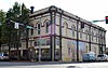 | 1. Juni 1982 ID-Nr. 82003751 | 18 SW Emigrant Ave. 45° 40′ 13,4″ N, 118° 47′ 11,2″ W45.670397-118.786454 | Pendleton | |
| 24 | Matlock–Brownfield Building | 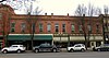 | 1. Juni 1982 ID-Nr. 82003752 | 413–425 S. Main St. 45° 40′ 12,7″ N, 118° 47′ 10,8″ W45.670206-118.786339 | Pendleton | |
| 25 | Meacham Hotel |  | 6. Aug. 2002 ID-Nr. 01000830 | Main St. 45° 30′ 28″ N, 118° 25′ 10″ W45.507778-118.419444 | Meacham | |
| 26 | Milarkey Building |  | 23. Sep. 1982 ID-Nr. 82003753 | 203 S. Main St. 45° 40′ 20,9″ N, 118° 47′ 15,9″ W45.672459-118.787762 | Pendleton | |
| 27 | Reese and Redman General Merchandise Store | 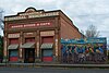 | 8. Aug. 1994 ID-Nr. 94000811 | 130 S. Main St. 45° 45′ 59″ N, 118° 33′ 44″ W45.766389-118.562222 | Adams | |
| 28 | St. Peter's Roman Catholic Church |  weitere Bilder | 28. Aug. 1997 ID-Nr. 97000905 | Junction of Marble St. and Leezer Ave. 45° 44′ 23,3″ N, 119° 12′ 4,9″ W45.739818-119.201365 | Echo | |
| 29 | Isham Saling House | 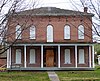 | 1. Jan. 1976 ID-Nr. 76001590 | 314 N. Water St. 45° 49′ 1″ N, 118° 25′ 26″ W45.816944-118.423889 | Weston | |
| 30 | Edgar Sommerville House |  | 14. Okt. 1980 ID-Nr. 80003382 | 104 SE 5th St. 45° 40′ 28,9″ N, 118° 46′ 58″ W45.674689-118.782779 | Pendleton | |
| 31 | South Main Street Commercial Historic District |  weitere Bilder | 10. Okt. 1986 ID-Nr. 86003260 | Etwa zwischen Dorion Ave., SE 1st St., Union Pacific Railroad, und SW 2nd St. 45° 40′ 14,3″ N, 118° 47′ 10,4″ W45.67063-118.78623 | Pendleton | |
| 32 | Still–Perkins House |  | 9. Sep. 1993 ID-Nr. 93000925 | 112 SE 6th Ave. 45° 55′ 49″ N, 118° 22′ 59″ W45.930278-118.383056 | Milton-Freewater | |
| 33 | Umatilla County Library | 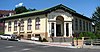 weitere Bilder | 15. Aug. 1997 ID-Nr. 97000848 | 214 N. Main St. 45° 40′ 28,2″ N, 118° 47′ 19,1″ W45.674504-118.788633 | Pendleton | |
| 34 | Umatilla Masonic Lodge Hall |  | 28. Aug. 1997 ID-Nr. 97000906 | 20 S. Dupont St. 45° 44′ 30,2″ N, 119° 11′ 47,3″ W45.741727-119.196485 | Echo | |
| 35 | Umatilla Site (35UM1) | 30. Jan. 1981 ID-Nr. 81000522 | Adresse nicht veröffentlicht | Umatilla | Prähistorischer Teil der Ausgrabungsstätte Umatilla Site (Objekte aus dem Jahr 470 v. Chr. und früher) | |
| 36 | U.S. Post Office and Courthouse | 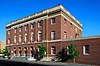 weitere Bilder | 4. März 1985 ID-Nr. 85000544 | 104 SW Dorion Ave. 45° 40′ 15,6″ N, 118° 47′ 17″ W45.671002-118.788059 | Pendleton | |
| 37 | Joseph Vey House |  | 27. Feb. 1986 ID-Nr. 86000299 | 1304 SE Court Pl. 45° 40′ 24,6″ N, 118° 46′ 19,9″ W45.673495-118.772185 | Pendleton | |
| 38 | Walla Walla Valley Traction Company Passenger Station and Powerhouse |  | 9. Sep. 1993 ID-Nr. 93000926 | 403 Robbins St. 45° 56′ 25,7″ N, 118° 23′ 46,3″ W45.94047-118.3962 | Milton-Freewater | |
| 39 | M. L. Watts House | 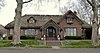 | 9. März 1988 ID-Nr. 88000090 | 4th at Jefferson St. 45° 48′ 47″ N, 118° 29′ 16″ W45.813056-118.487778 | Athena | |
| 40 | Weston Commercial Historic District |  weitere Bilder | 5. Okt. 1982 ID-Nr. 82001515 | E. Main St. zwischen Water und Broad St. 45° 48′ 49″ N, 118° 25′ 26,7″ W45.813609-118.42408 | Weston | |
| 41 | Weston School |  | 30. Dez. 2011 ID-Nr. 11000976 | 205 E. Wallace St. 45° 48′ 43,6″ N, 118° 25′ 23,6″ W45.812122-118.423211 | Weston | |
| 42 | Winn Barn |  | 30. Dez. 2011 ID-Nr. 11000977 | 79560 Winn Rd. 45° 50′ 25,3″ N, 118° 24′ 19,1″ W45.840353-118.405303 | Weston (Umgebung) |
Weblinks
- Oregon Parks and Recreation Department, National Register Program
- National Park Service, National Register of Historic Places site
Commons: National Register of Historic Places in Umatilla County, Oregon – Sammlung von Bildern
Einzelnachweise
- ↑ Originals vom 26. Januar 2011 im Internet Archive) Info: Der Archivlink wurde automatisch eingesetzt und noch nicht geprüft. Bitte prüfe Original- und Archivlink gemäß Anleitung und entferne dann diesen Hinweis.@1@2Vorlage:Webachiv/IABot/www.cr.nps.gov
- ↑ Die Nummerierung in dieser Listenspalte ist an der vom National Park Service vorgelegten Reihenfolge der Einträge orientiert; die Farben unterscheiden verschiedene Schutzgebietstypen des Nationalparksystems mit landesweiter Bedeutung (z. B. National Historic Landmarks) von den sonstigen Einträgen im National Register of Historic Places.
- ↑ Donovan, Sally; Kadas, Marianne, National Register of Historic Places Registration Form: Echo Methodist Episcopal Church, December 15, 1996 (PDF)


Einträge im National Register of Historic Places in Oregon
National Register of Historic Places in Oregon
Baker | Benton | Clackamas | Clatsop | Columbia | Coos | Crook | Curry | Deschutes | Douglas | Gilliam | Grant | Harney | Hood River | Jackson | Jefferson | Josephine | Klamath | Lake | Lane | Lincoln | Linn | Malheur | Marion | Morrow | Multnomah | Polk | Sherman | Tillamook | Umatilla | Union | Wallowa | Wasco | Washington | Wheeler | Yamhill
Evansville (Mississippi)


