Montertelot
| Montertelot Montertelo | ||
|---|---|---|
| ||
| Staat | Frankreich | |
| Region | Bretagne | |
| Département (Nr.) | Morbihan (56) | |
| Arrondissement | Pontivy | |
| Kanton | Ploërmel | |
| Gemeindeverband | Ploërmel Communauté | |
| Koordinaten | 47° 53′ N, 2° 25′ W47.881388888889-2.4208333333333Koordinaten: 47° 53′ N, 2° 25′ W | |
| Höhe | 19–100 m | |
| Fläche | 2,64 km² | |
| Einwohner | 365 (1. Januar 2021) | |
| Bevölkerungsdichte | 138 Einw./km² | |
| Postleitzahl | 56800 | |
| INSEE-Code | 56139 | |
 Rathaus von Montertelot | ||


Montertelot (Gallo Montertelo, bretonisch Mousterdelav) ist eine französische Gemeinde mit 365 Einwohnern (Stand 1. Januar 2021) im Département Morbihan in der Region Bretagne.
Geografie
Montertelot liegt rund 36 Kilometer nordöstlich von Vannes im Nordosten des Départements Morbihan und gehört zum Gemeindeverband Ploërmel Communauté.
Nachbargemeinden sind Ploërmel im Norden, Val d’Oust im Osten und Süden sowie Le Roc-Saint-André im Westen.
Bevölkerungsentwicklung
| Jahr | 1962 | 1968 | 1975 | 1982 | 1990 | 1999 | 2006 | 2012 | 2019 |
| Einwohner | 213 | 227 | 242 | 268 | 279 | 255 | 322 | 366 | 360 |
| Quellen: Cassini und INSEE | |||||||||
Sehenswürdigkeiten
- Kirche Saint-Laur
-
 Calvaire in Montertelot
 -
 Quelle Saint-Laur
 -
 Kreuz in Montertelot
 -
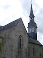 Kirche Saint-Laur


Literatur
- Le Patrimoine des Communes du Morbihan. Flohic Editions, Band 2, Paris 1996, ISBN 2-84234-009-4, S. 658.
Sprache
Im Frühmittelalter wurde die Gegend durch Bretonen besiedelt und deren Umgangssprache Alltagssprache. Bei der Zweiten Rückzugswelle der Bretonischen Sprache im Spätmittelalter (zwischen 1200 und 1500) kam es zum Sprachwechsel hin zum Gallo. Dieser Dialekt des Französischen ist mittlerweile beinahe ausgestorben und die Bevölkerung spricht heute französisch.
Weblinks
Commons: Montertelot – Sammlung von Bildern, Videos und Audiodateien
- Infos zur Geschichte und den Sehenswürdigkeiten
Normdaten (Geografikum): VIAF: 105144647651239525783


