Čajetina
Village and municipality in Šumadija and Western Serbia, Serbia
Čajetina Чајетина (Serbian) | |
|---|---|
Village and municipality | |
   | |
 Coat of arms | |
 Location of the municipality of Čajetina within Serbia | |
| Coordinates: 43°45′N 19°43′E / 43.750°N 19.717°E / 43.750; 19.717 | |
| Country |  Serbia Serbia |
| Region | Šumadija and Western Serbia |
| District | Zlatibor |
| Settlements | 20 |
| Government | |
| • Mayor | Milan Stamatović (ZS) |
| Area | |
| • Urban | 39.32 km2 (15.18 sq mi) |
| • Municipality | 647 km2 (250 sq mi) |
| Elevation | 843 m (2,766 ft) |
| Population (2022 census)[3] | |
| • Urban | 3,702 |
| • Urban density | 94/km2 (240/sq mi) |
| • Municipality | 14,585 |
| • Municipality density | 23/km2 (58/sq mi) |
| Time zone | UTC+1 (CET) |
| • Summer (DST) | UTC+2 (CEST) |
| Postal code | 31310 |
| Area code | +381(0)31 |
| Car plates | UE |
| Website | www |
Čajetina (Serbian Cyrillic: Чајетина) is a small town and municipality located in the Zlatibor District of western Serbia. According to the 2022 census results, the municipality has 14,585 inhabitants. One of the most notable settlements in the municipality of Čajetina is a popular tourist town of Zlatibor.
Climate
Čajetina has a humid continental climate (Köppen climate classification: Dfb).
| Climate data for Čajetina | |||||||||||||
|---|---|---|---|---|---|---|---|---|---|---|---|---|---|
| Month | Jan | Feb | Mar | Apr | May | Jun | Jul | Aug | Sep | Oct | Nov | Dec | Year |
| Mean daily maximum °C (°F) | 1.2 (34.2) | 4.1 (39.4) | 9.0 (48.2) | 12.5 (54.5) | 17.3 (63.1) | 20.8 (69.4) | 23.0 (73.4) | 23.2 (73.8) | 19.9 (67.8) | 14.8 (58.6) | 7.5 (45.5) | 2.9 (37.2) | 13.0 (55.4) |
| Daily mean °C (°F) | −2.1 (28.2) | 0.3 (32.5) | 4.5 (40.1) | 7.7 (45.9) | 12.3 (54.1) | 15.7 (60.3) | 17.7 (63.9) | 17.7 (63.9) | 14.6 (58.3) | 10.1 (50.2) | 4.0 (39.2) | −0.1 (31.8) | 8.5 (47.4) |
| Mean daily minimum °C (°F) | −5.4 (22.3) | −3.5 (25.7) | 0.0 (32.0) | 3.0 (37.4) | 7.4 (45.3) | 10.7 (51.3) | 12.4 (54.3) | 12.3 (54.1) | 9.3 (48.7) | 5.4 (41.7) | 0.5 (32.9) | −3.1 (26.4) | 4.1 (39.3) |
| Average precipitation mm (inches) | 67 (2.6) | 59 (2.3) | 60 (2.4) | 75 (3.0) | 100 (3.9) | 99 (3.9) | 89 (3.5) | 74 (2.9) | 78 (3.1) | 77 (3.0) | 86 (3.4) | 76 (3.0) | 940 (37) |
| Source: Climate-Data.org [4] | |||||||||||||
Settlements
Aside from the town of Čajetina, the municipality comprises the following settlements:
- Alin Potok
- Branešci
- Golovo
- Gostilje
- Dobroselica
- Drenova
- Željine
- Zlatibor
- Jablanica
- Kriva Reka
- Ljubiš
- Mačkat
- Mušvete
- Rakovica
- Rožanstvo
- Rudine
- Sainovina
- Semegnjevo
- Sirogojno
- Stublo
- Tripkova
- Trnava
- Šljivovica
Demographics
| Year | Pop. | ±% p.a. |
|---|---|---|
| 1948 | 20,266 | — |
| 1953 | 21,529 | +1.22% |
| 1961 | 20,716 | −0.48% |
| 1971 | 19,224 | −0.74% |
| 1981 | 17,098 | −1.17% |
| 1991 | 15,996 | −0.66% |
| 2002 | 15,628 | −0.21% |
| 2011 | 14,745 | −0.64% |
| 2022 | 14,585 | −0.10% |
| Source: [5][6] | ||
According to the 2022 census results, the municipality has 14,585 inhabitants.
Ethnic groups
The ethnic composition of the municipality as of 2022:
| Ethnic group | Population | % |
|---|---|---|
| Serbs | 13,695 | 93.90% |
| Montenegrins | 24 | 0.16% |
| Croats | 16 | 0.11% |
| Russians | 14 | 0.10% |
| Others | 66 | 0.45% |
| Undeclared | 164 | 1.12% |
| Unknown | 606 | 4.15% |
| Total | 14,585 |
Economy
The following table gives a preview of total number of registered people employed in legal entities per their core activity (as of 2018):[7]
| Activity | Total |
|---|---|
| Agriculture, forestry and fishing | 93 |
| Mining and quarrying | 4 |
| Manufacturing | 1,156 |
| Electricity, gas, steam and air conditioning supply | 33 |
| Water supply; sewerage, waste management and remediation activities | 171 |
| Construction | 284 |
| Wholesale and retail trade, repair of motor vehicles and motorcycles | 676 |
| Transportation and storage | 124 |
| Accommodation and food services | 1,285 |
| Information and communication | 26 |
| Financial and insurance activities | 34 |
| Real estate activities | 8 |
| Professional, scientific and technical activities | 99 |
| Administrative and support service activities | 126 |
| Public administration and defense; compulsory social security | 269 |
| Education | 226 |
| Human health and social work activities | 375 |
| Arts, entertainment and recreation | 202 |
| Other service activities | 84 |
| Individual agricultural workers | 174 |
| Total | 5,450 |
Gallery
-
 Zlatibor town center with lake
 -
 Zlatibor town center
 -
 Zlatibor lake with surroundings
 -
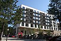 Zlatibor Spa Hotel
 -
 Zlatibor landscape
 -
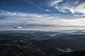 Zlatibor landscape from Ravni Tornik
 -
 Zlatibor panorama
 -
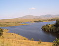 Ribnica Lake
 -
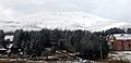
 Sirogojno
 -
 Stopića cave
 -
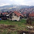 Čajetina town panorama
 -
 Čajetina Library
 -
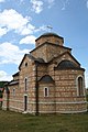
 Uvac Monastery
 -
 St. Gabriel Church
 -
 Kriva Reka Church
 -
 Zlatibor Church


Twin towns


References
- ^ "Municipalities of Serbia, 2006". Statistical Office of Serbia. Retrieved 2010-11-28.
- ^ "Насеља општине Чајетина" (PDF). stat.gov.rs (in Serbian). Statistical Office of Serbia. Retrieved 12 October 2019.
- ^ "2022 Census of Population, Households and Dwellings: Ethnicity (data by municipalities and cities)" (PDF). Statistical Office of Republic Of Serbia, Belgrade. April 2023. ISBN 978-86-6161-228-2. Retrieved 2023-04-30.
- ^ "Climate: Čajetina, Serbia". Climate-Data.org. Retrieved 15 February 2018.
- ^ "2011 Census of Population, Households and Dwellings in the Republic of Serbia" (PDF). stat.gov.rs. Statistical Office of the Republic of Serbia. Retrieved 11 January 2017.
- ^ "2022 Census of Population, Households and Dwellings: Ethnicity (data by municipalities and cities)" (PDF). Statistical Office of Republic Of Serbia, Belgrade. April 2023. ISBN 978-86-6161-228-2. Retrieved 2023-04-30.
- ^ "MUNICIPALITIES AND REGIONS OF THE REPUBLIC OF SERBIA, 2019" (PDF). stat.gov.rs. Statistical Office of the Republic of Serbia. 25 December 2019. Retrieved 28 December 2019.
External links
Wikimedia Commons has media related to Čajetina.
- Official website
- v
- t
- e
Cities, towns and villages in the Zlatibor District
- Bioska
- Bjelotići
- Buar
- Dobrodo
- Drežnik
- Drijetanj
- Duboko
- Gorjani
- Gostinica
- Gubin Do
- Kačer
- Kamenica
- Karan
- Keserovina
- Kotroman
- Kremna
- Kršanje
- Krvavci
- Lelići
- Ljubanje
- Mokra Gora
- Nikojevići
- Panjak
- Pear
- Ponikovica
- Potočanje
- Potpeće
- Raduša
- Ravni
- Ribaševina
- Sevojno
- Skržuti
- Stapari
- Strmac
- Trnava
- Vitasi
- Volujac
- Vrutci
- Zbojštica
- Zlakusa
- Bjeloperica
- Brajkovići
- Cikote
- Donja Pološnica
- Drenovci
- Dubnica
- Galovići
- Godečevo
- Godljevo
- Gornja Pološnica
- Makovište
- Mionica
- Mrčići
- Mušići
- Paramun
- Radanovci
- Rosići
- Ruda Bukva
- Seča Reka
- Ševrljuge
- Skakavci
- Stojići
- Subjel
- Tubići
- Varda
- Bakionica
- Čestobrodica
- Donja Dobrinja
- Dražinovići
- Duškovci
- Glumač
- Godovik
- Gornja Dobrinja
- Gorobilje
- Gugalj
- Jelen Do
- Kalenići
- Lopaš
- Loret
- Ljutice
- Mađer
- Mala Ježevica
- Milićevo Selo
- Mršelji
- Otanj
- Papratište
- Pilatovići
- Prijanovići
- Prilipac
- Radovci
- Rasna
- Rečice
- Roge
- Rupeljevo
- Srednja Dobrinja
- Svračkovo
- Tabanovići
- Tometino Polje
- Tučkovo
- Tvrdići
- Uzići
- Velika Ježevica
- Visibaba
- Vranjani
- Zaselje
- Zdravčići
- Alin Potok
- Branešci
- Dobroselica
- Drenova
- Golovo
- Gostilje
- Jablanica
- Kriva Reka
- Ljubiš
- Mačkat
- Mušvete
- Rakovica
- Rožanstvo
- Rudine
- Sainovina
- Semegnjevo
- Sirogojno
- Šljivovica
- Stublo
- Tripkova
- Trnava
- Željine
- Zlatibor
- Aljinovići
- Balići
- Bare
- Biskupići
- Bjelahova
- Brajkovac
- Brodarevo
- Brvine
- Bukovik
- Čadinje
- Čauševići
- Crkveni Toci
- Divci
- Donje Babine
- Donji Stranjani
- Drenova
- Đurašići
- Dušmanići
- Džurovo
- Gojakovići
- Gornje Babine
- Gornje Goračiće
- Gornji Stranjani
- Gostun
- Gračanica
- Grobnice
- Hisardžik
- Hrta
- Ivanje
- Ivezići
- Izbičanj
- Jabuka
- Junčevići
- Kaćevo
- Kamena Gora
- Karaula
- Karoševina
- Kašice
- Koprivna
- Kosatica
- Koševine
- Kovačevac
- Kruševo
- Kučin
- Ljiljci
- Lučice
- Mataruge
- Međani
- Mijani
- Mijoska
- Milakovići
- Mileševo
- Miljevići
- Milošev Do
- Mrčkovina
- Muškovina
- Oraovac
- Orašac
- Osoje
- Oštra Stijena
- Potkrš
- Potok
- Pranjci
- Pravoševo
- Rasno
- Ratajska
- Sedobro
- Seljane
- Seljašnica
- Skokuće
- Slatina
- Sopotnica
- Taševo
- Vinicka
- Velika Zupa
- Vrbovo
- Zabrdnji Toci
- Zalug
- Zastup
- Zavinograđe
- Zvijezd
- Aliveroviće
- Bagačiće
- Bare
- Bačija
- Bioc
- Blato
- Boguti
- Božov Potok
- Boljare
- Borišiće
- Boroviće
- Breza
- Brnjica
- Buđevo
- Caričina
- Cetanoviće
- Čedovo
- Čipalje
- Čitluk
- Crčevo
- Crvsko
- Doliće
- Donje Goračiće
- Donje Lopiže
- Dragojloviće
- Draževiće
- Družiniće
- Dubnica
- Duga Poljana
- Dujke
- Dunišiće
- Fijulj
- Goluban
- Gornje Lopiže
- Goševo
- Grabovica
- Gradac
- Grgaje
- Jevik
- Jezero
- Kalipolje
- Kamešnica
- Kanjevina
- Karajukića Bunari
- Kijevci
- Kladnica
- Kneževac
- Koznik
- Kokošiće
- Krajinoviće
- Krivaja
- Krće
- Krnja Jela
- Krstac
- Lijeva Reka
- Ljutaje
- Mašoviće
- Medare
- Međugor
- Milići
- Papiće
- Petrovo Polje
- Plana
- Poda
- Ponorac
- Pralja
- Raškoviće
- Rasno
- Raspoganče
- Rastenoviće
- Raždaginja
- Šare
- Skradnik
- Štavalj
- Strajiniće
- Stup
- Sugubine
- Sušica
- Šušure
- Trešnjevica
- Trijebine
- Tutiće
- Tuzinje
- Ugao
- Ursule
- Ušak
- Uvac
- Vapa
- Veskoviće
- Visočka
- Višnjeva
- Višnjice
- Vrapci
- Vrbnica
- Vrsjenice
- Zabrđe
- Žabren
- Zahumsko
- Zaječiće
- Žitniće
- Akmačići
- Banja
- Batkovići
- Brezna
- Bučje
- Čitluk
- Crnugovići
- Crnuzi
- Dobrilovići
- Hercegovačka Goleša
- Jelača
- Kalafati
- Kaluđerovići
- Kasidoli
- Kratovo
- Krnjača
- Kukurovići
- Mažići
- Miliješ
- Plašće
- Požegrmac
- Pribojska Goleša
- Pribojske Čelice
- Rača
- Ritošići
- Sjeverin
- Sočice
- Strmac
- Zabrđe
- Zabrnjica
- Zagradina
- Zaostro
- Živinice
Municipalities or cities of Serbia


 | This Zlatibor District, Serbia location article is a stub. You can help Wikipedia by expanding it. |
- v
- t
- e


