Al-Hay
Town in Wasit, Iraq
Al-Hay الحي | |
|---|---|
Town | |
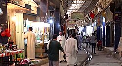 Al-Hay Bazaar, July 2018 | |
| 32°10′N 46°03′E / 32.167°N 46.050°E / 32.167; 46.050 | |
| Country |  Iraq Iraq |
| Governorate | Wasit |
Al-Hay (Arabic: الحي) is a town located in Iraq's Wasit Province. It 45 kilometers south of the Kut and 220 kilometers south of Baghdad. It has a population of 85,500 citizens.
Climate
| Climate data for Al-Hai (1991–2020) | |||||||||||||
|---|---|---|---|---|---|---|---|---|---|---|---|---|---|
| Month | Jan | Feb | Mar | Apr | May | Jun | Jul | Aug | Sep | Oct | Nov | Dec | Year |
| Mean daily maximum °C (°F) | 17.3 (63.1) | 20.3 (68.5) | 25.6 (78.1) | 31.9 (89.4) | 38.7 (101.7) | 43.7 (110.7) | 45.6 (114.1) | 45.8 (114.4) | 42.2 (108.0) | 35.6 (96.1) | 25.5 (77.9) | 19.3 (66.7) | 32.6 (90.7) |
| Daily mean °C (°F) | 11.8 (53.2) | 14.3 (57.7) | 19.2 (66.6) | 25.2 (77.4) | 31.7 (89.1) | 36.2 (97.2) | 38.0 (100.4) | 37.6 (99.7) | 33.6 (92.5) | 28.0 (82.4) | 18.9 (66.0) | 13.4 (56.1) | 25.7 (78.3) |
| Mean daily minimum °C (°F) | 7.0 (44.6) | 9.0 (48.2) | 13.2 (55.8) | 18.5 (65.3) | 24.6 (76.3) | 28.3 (82.9) | 29.9 (85.8) | 29.6 (85.3) | 25.6 (78.1) | 20.7 (69.3) | 13.2 (55.8) | 8.9 (48.0) | 19.0 (66.2) |
| Average precipitation mm (inches) | 27.3 (1.07) | 14.6 (0.57) | 19.2 (0.76) | 15.0 (0.59) | 4.2 (0.17) | 0.0 (0.0) | 0.2 (0.01) | 0.0 (0.0) | 0.7 (0.03) | 6.6 (0.26) | 26.0 (1.02) | 21.4 (0.84) | 135.2 (5.32) |
| Source: NOAA[1] | |||||||||||||
References
- ^ "World Meteorological Organization Climate Normals for 1991-2020 — Al-Hai". National Oceanic and Atmospheric Administration. Retrieved January 1, 2024.
External links
- Wasit province [permanent dead link]
- v
- t
- e
Districts of Iraq and their capitals
- Anah District (Anah)
- Fallujah District (Fallujah)
- Haditha District (Haditha)
- Hit District (Hit)
- al-Qa'im District (Al-Qa'im)
- Ramadi District (Ramadi)
- Rawah District (Rawah)
- ar-Rutba District (Ar-Rutbah)

- al-Chibayish District (Al-Chibayish)
- Nasiriyah District (Nasiriyah)
- al-Rifa'i District (Al-Rifa'i)
- al-Shatrah District (Al-Shatrah)
- Suq al-Shuyukh District (Suq Al-Shoyokh)
- Byara District (Byara)
- Halabja District (Halabja)
- Khurmal District (Khurmal)
- Sirwan District (Sirwan)
- Daquq District (Daquq)
- Dibis District (Dibis)
- Hawija District (Hawija)
- Kirkuk District (Kirkuk)
- Ali Al-Gharbi District (Ali Al-Gharbi)
- Amara District (Amarah)
- al-Kahla District (Al-Kahla)
- al-Maimouna District (Al-Maimouna)
- al-Mejar Al-Kabi District (Al-Mejar Al-Kabi)
- Qal'at Saleh District (Qal'at Saleh)
- al-Khidhir District (Al-Khidhir)
- al-Rumaitha District (Al-Rumaitha)
- al-Salman District (Al-Salman)
- al-Samawa District (Samawah)
- Kufa District (Kufa)
- al-Manathera District (Al-Manathera)
- al-Meshkhab District (Al-Meshkhab)
- Najaf District (Najaf)
- Afak District (Afak)
- Diwaniya District (Al Diwaniyah)
- Hamza District (Hamza)
- al-Shamiya District (Al-Shamiya )
- Chamchamal District (Chamchamal)
- Darbandikhan District (Darbandikhan)
- Dokan District (Dokan)
- Kalar District (Kalar)
- Kifri District (Kifri)
- Mawat District (Mawat)
- Penjwen District (Penjwen)
- Pshdar District (Qaladiza)
- Qaradagh District (Qaradagh)
- Ranya District (Ranya)
- Saidsadiq District (Said Sadiq)
- Sharazoor District (Zarayan)
- Sharbazher District (Sharbazher)
- Sulaymaniyah District (Sulaymaniyah)
- Al-Aziziyah District (Al-Aziziyah)
- Badra District (Badra)
- al-Hai District (Al-Hay)
- Kut District (Kut)
- al-Nu'maniya District (Al-Nu'maniya)
- al-Suwaira District (Al-Suwaira)
 | This Iraq geographical location article is a stub. You can help Wikipedia by expanding it. |
- v
- t
- e


