Al-Qusayr District

District in Homs, Syria
Al-Qusayr District
منطقة القصير
District
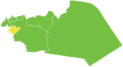
Map of Al-Qusayr District within Homs Governorate
Coordinates (Al-Qusayr): 34°30′43″N 36°34′35″E / 34.5119°N 36.5764°E / 34.5119; 36.5764
Country Syria
GovernorateHoms
SeatAl-Qusayr
Subdistricts2 nawāḥī
Area
 • Total598.80 km2 (231.20 sq mi)
Population
 (2004)[1]
 • Total107,470
 • Density180/km2 (460/sq mi)
GeocodeSY0402

Al-Qusayr District (Arabic: منطقة القصير, romanized: manṭiqat al-Qusair) is a district of the Homs Governorate in central Syria. The administrative centre is the city of Al-Qusayr. At the 2004 census, the district had a population of 107,470.[1]

Sub-districts

The district of Al-Qusayr is divided into two sub-districts or nawāḥī (population as of 2004[1]):

  • Al-Qusayr Subdistrict (ناحية القصير): population 70,965.
  • Al-Hoz Subdistrict (ناحية الحوز): population 36,505. - formed in 2010

Localities of the sub-district

According to the Central Bureau of Statistics (CBS), the following villages along with the towns of al-Qusayr and Al-Hoz, make up the district of al-Qusayr:

  • al-Fadhliyah 798 / (Arabic: الفاضلية)
  • al-Burhaniyah (al-Radwaniyah) 744 / (Arabic: البرهانية_الرضوانية)
  • al-Saloumiyah 725 / (Arabic: السلومية)
  • al-Shoumariyah 713 / (Arabic: الشومرية)
  • Diyabiyah 698 / (Arabic: ديابية)
  • Ras al-Ain (Hasabiyah) 690 / (Arabic: رأس العين_حسابية)
  • Saqirjah (Ain al-Tannour) 674 / (Arabic: سقرجة_عين التنور)
  • al-Sakher (Hit) 656 / (Arabic: الصخر_هيت)
  • Abou Jouri 652 / (Arabic: أبو جوري)
  • al-Masriyah 618 / (Arabic: المصرية)
  • Hawsh al-Said Ali 541 / (Arabic: حوش السيد علي)
  • al-Nahriyah 529 / (Arabic: النهرية)
  • al-Hammam 526 / (Arabic: الحمام)
  • al-Shiahat 520 / (Arabic: الشياحات)
  • Ain al-Safa (Akoum) 506 / (Arabic: عين الصفا_أكوم)
  • Kammam 474 / (Arabic: كمام)
  • al-Hamra 431 / (Arabic: الحمراء)
  • Wadi al-Hourani 379 / (Arabic: وادي الحوراني)
  • al-Muh 377 / (Arabic: الموح)
  • Umm Haratain Atiq 345 / (Arabic: أم حارتين عتيق)
  • al-Aatafiyah 317 / (Arabic: العاطفية)
  • al-Khaldiyah 270 / (Arabic: الخالدية)
  • al-Masitbah 258 / (Arabic: المصيطبة)
  • al-Buwait 181 / (Arabic: البويت)
  • Dahiraj 156 / (Arabic: دحيرج)
  • Wadi Hanna 138 / (Arabic: وادي حنا)
  • al-Andalus 106 / (Arabic: الأندلس)
  • Koukran (al-Sadiat) 102 / (Arabic: كوكران_السعديات)
  • al-Hamidiyah 64 / (Arabic: الحامدية)
  • al-Haidariyah 56 / (Arabic: الحيدرية)

References

  1. ^ a b c "2004 Census Data". UN OCHA. Retrieved 15 October 2015.
Stub icon

This article about a location in Homs Governorate, Syria is a stub. You can help Wikipedia by expanding it.

  • v
  • t
  • e