Antonio Zatta
You can help expand this article with text translated from the corresponding article in Croatian. (September 2014) Click [show] for important translation instructions.
- View a machine-translated version of the Croatian article.
- Machine translation, like DeepL or Google Translate, is a useful starting point for translations, but translators must revise errors as necessary and confirm that the translation is accurate, rather than simply copy-pasting machine-translated text into the English Wikipedia.
- Do not translate text that appears unreliable or low-quality. If possible, verify the text with references provided in the foreign-language article.
- You must provide copyright attribution in the edit summary accompanying your translation by providing an interlanguage link to the source of your translation. A model attribution edit summary is
Content in this edit is translated from the existing Croatian Wikipedia article at [[:hr:Antonio Zatta]]; see its history for attribution. - You may also add the template
{{Translated|hr|Antonio Zatta}}to the talk page. - For more guidance, see Wikipedia:Translation.
Antonio Zatta (fl. 1757 – April 2, 1797) was an Italian cartographer and publisher who was based in Venice. He may have lived from 1722 to 1804.[1] One of his major contributions includes the Atlante Novissimo, a four volume atlas of the world.[2] Also, his grand study of St Mark's Basilica in Venice, printed in 1761.

He also published an edition of the plays of Goldoni with engravings in 1789.
Gallery
-
 1784 map of Chinese Tartary and Korea
 -
 1782 map of the Kingdom of Naples
 -
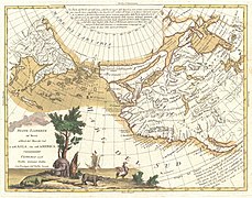 1776 map of the North Pacific coast, particularly of North America. Note the erroneous presence of a Chinese colony "Fou-Sang", and the rumoured Strait of Anián.
 -
 1779 map of the Kingdom of Bohemia
 -
 1781 map of Eastern Europe
 -
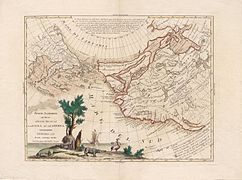 Another version of the above map of the North Pacific (1776)


See also
References
External links
Wikimedia Commons has media related to Antonio Zatta.
- Antonio Zatta at Geographicus.com
- Antonio Zatta at alteagallery.com
- Antonio Zatta at bergbook.com
- Works by or about Antonio Zatta at Internet Archive
Authority control databases | |
|---|---|
| International |
|
| National |
|
| Artists |
|
| People |
|
| Other |
|


