Argari | |
|---|---|
Census Town | |
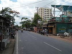 Andul Road (part of SH 6), Argari | |
 Argari Location in West Bengal, India  Argari Argari (India) | |
| Coordinates: 22°35′N 88°13′E / 22.58°N 88.22°E | |
| Country | |
| State | West Bengal |
| District | Howrah |
| Population (2011) | |
• Total | 10,715 |
| Languages | |
| • Official | Bengali, English |
| Time zone | UTC+5:30 (IST) |
| Vehicle registration | WB |
| Lok Sabha constituency | Howrah |
| Vidhan Sabha constituency | Sankrail |
| Website | howrah |
Argari is a census town in Sankrail CD Block of Howrah Sadar subdivision in Howrah district in the Indian state of West Bengal.[1]
Geography
[edit]Argari is located at 22°35′15″N 88°13′34″E / 22.5876°N 88.22617°E. It is situated between Andul and Alampur.
Demographics
[edit]
As per 2011 Census of India Argari had a total population of 10,715 of which 5,555 (52%) were males and 5,160 (48%) were females. Population below 6 years was 1,217. The total number of literates in Argari was 8,156 (85.87% of the population over 6 years).[2]
Argari was part of Kolkata Urban Agglomeration in 2011 census.[3]
As of 2001[update] India census,[4] Argari had a population of 9525. Males constitute 52% of the population and females 48%. Argari has an average literacy rate of 66%, higher than the national average of 59.5%; with 54% of the males and 46% of females literate. 13% of the population is under 6 years of age.
Transport
[edit]Andul Road (part of Grand Trunk Road/State Highway 6)[5][6] is the artery of the town.
Bus
[edit]Private Bus
[edit]- 61 Alampur - Howrah Station
Mini Bus
[edit]- 13 Ranihati - Rajabazar
- 13A Fatikgachi - Rajabazar
- 20 Alampur - Ultadanga Station
Bus Routes Without Numbers
[edit]Train
[edit]Andul railway station and Mourigram railway station on Howrah-Kharagpur line are the nearest railway stations of Argari.
Climate
[edit]| Climate data for Bagati (1991–2020 normals, extremes 1971–2007) | |||||||||||||
|---|---|---|---|---|---|---|---|---|---|---|---|---|---|
| Month | Jan | Feb | Mar | Apr | May | Jun | Jul | Aug | Sep | Oct | Nov | Dec | Year |
| Record high °C (°F) | 33.3 (91.9) |
36.8 (98.2) |
39.8 (103.6) |
44.5 (112.1) |
45.5 (113.9) |
46.2 (115.2) |
39.3 (102.7) |
37.3 (99.1) |
37.9 (100.2) |
38.4 (101.1) |
38.5 (101.3) |
36.5 (97.7) |
46.2 (115.2) |
| Mean daily maximum °C (°F) | 23.8 (74.8) |
27.6 (81.7) |
32.2 (90.0) |
34.9 (94.8) |
35.2 (95.4) |
33.4 (92.1) |
31.7 (89.1) |
31.6 (88.9) |
31.6 (88.9) |
31.2 (88.2) |
28.9 (84.0) |
25.2 (77.4) |
30.6 (87.1) |
| Mean daily minimum °C (°F) | 12.6 (54.7) |
16.4 (61.5) |
20.9 (69.6) |
24.5 (76.1) |
25.5 (77.9) |
26.3 (79.3) |
26.2 (79.2) |
26.3 (79.3) |
26.0 (78.8) |
24.0 (75.2) |
18.9 (66.0) |
13.9 (57.0) |
21.7 (71.1) |
| Record low °C (°F) | 0.8 (33.4) |
5.5 (41.9) |
11.0 (51.8) |
15.1 (59.2) |
14.5 (58.1) |
14.2 (57.6) |
19.1 (66.4) |
20.8 (69.4) |
16.7 (62.1) |
16.6 (61.9) |
10.0 (50.0) |
6.4 (43.5) |
0.8 (33.4) |
| Average rainfall mm (inches) | 15.0 (0.59) |
23.1 (0.91) |
38.2 (1.50) |
50.2 (1.98) |
130.5 (5.14) |
257.4 (10.13) |
320.9 (12.63) |
273.8 (10.78) |
247.7 (9.75) |
126.1 (4.96) |
21.5 (0.85) |
4.6 (0.18) |
1,509.1 (59.41) |
| Average rainy days | 1.2 | 1.4 | 2.3 | 3.2 | 6.7 | 11.6 | 15.5 | 14.0 | 11.6 | 5.5 | 0.8 | 0.4 | 74.2 |
| Average relative humidity (%) (at 17:30 IST) | 62 | 58 | 60 | 65 | 67 | 77 | 82 | 82 | 82 | 78 | 69 | 64 | 70 |
| Source: India Meteorological Department[7] | |||||||||||||
References
[edit]- ^ "District-wise list of stautory towns". Census Commission of India. Archived from the original on 30 September 2007. Retrieved 28 January 2009.
- ^ "C.D. Block Wise Primary Census Abstract Data(PCA)". 2011 census: West Bengal – District-wise CD Blocks. Registrar General and Census Commissioner, India. Retrieved 11 May 2016.
- ^ "Provisional Population Totals, Census of India 2011" (PDF). Constituents of Urban Agglomeration Having Population Above 1 Lakh. Census of India 2011. Retrieved 11 May 2016.
- ^ "Census of India 2001: Data from the 2001 Census, including cities, villages and towns (Provisional)". Census Commission of India. Archived from the original on 16 June 2004. Retrieved 1 November 2008.
- ^ "List of State Highways in West Bengal". West Bengal Traffic Police. Retrieved 15 October 2016.
- ^ "Pin Code: ANDUL ROAD, HOWRAH, WEST BENGAL, India, Pincode.net.in". pincode.net.in. Retrieved 22 December 2018.
- ^ "Station: Bagati Climatological Table 1991–2020" (PDF). Climatological Normals 1991–2020. India Meteorological Department. Archived from the original (PDF) on 8 April 2024. Retrieved 17 July 2024.