| Banganapalle State బనగానపల్లె | |||||||
|---|---|---|---|---|---|---|---|
| Princely State | |||||||
| 1665–1948 | |||||||
|
Flag | |||||||
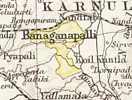
 Map of the princely state of Banganapalle, 1893 | |||||||
| Area | |||||||
• 1901 | 712 km2 (275 sq mi) | ||||||
| Population | |||||||
• 1901 | 32,279 | ||||||
| History | |||||||
• Established | 1665 | ||||||
| 1948 | |||||||
| |||||||
| Today part of | Andhra Pradesh, India | ||||||

Banganapalle State was one of the princely states of India during the period of the British Raj. The state was founded in 1665 and had its capital in Banganapalle. Its rulers were Shia Muslims and the last one signed the accession to the Indian Union on 23 February 1948.[1]
See also
[edit]References
[edit]- ^ "Banganapalle Princely State (9 gun salute)". Archived from the original on 1 April 2017. Retrieved 17 June 2014.
