Barysiai Airport
You can help expand this article with text translated from the corresponding article in Lithuanian. (December 2012) Click [show] for important translation instructions.
- View a machine-translated version of the Lithuanian article.
- Machine translation, like DeepL or Google Translate, is a useful starting point for translations, but translators must revise errors as necessary and confirm that the translation is accurate, rather than simply copy-pasting machine-translated text into the English Wikipedia.
- Consider adding a topic to this template: there are already 283 articles in the main category, and specifying
|topic=will aid in categorization. - Do not translate text that appears unreliable or low-quality. If possible, verify the text with references provided in the foreign-language article.
- You must provide copyright attribution in the edit summary accompanying your translation by providing an interlanguage link to the source of your translation. A model attribution edit summary is
Content in this edit is translated from the existing Lithuanian Wikipedia article at [[:lt:Barysių aerodromas]]; see its history for attribution. - You may also add the template
{{Translated|lt|Barysių aerodromas}}to the talk page. - For more guidance, see Wikipedia:Translation.
Airport in Barysiai, Lithuania


EYSB
Location of airport in Lithuania
| Direction | Length | Surface | |
|---|---|---|---|
| m | ft | ||
| 10/28 | 1,000 | 3,281 | Asphalt |
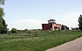
Barysiai Airport (Lithuanian: Barysių aerodromas) (ICAO: EYSB[3]) is an airport in Barysiai,[1] a village in the Joniškis district municipality of Šiauliai County in northern Lithuania. From 1959 to 1992 it was a civil airport serving the city of Šiauliai.
Facilities
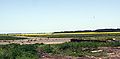
The airport resides at an elevation of 270 feet (82 m) above mean sea level. It has one runway designated 10/28 with an asphalt surface measuring 1,000 by 30 metres (3,281 ft × 98 ft).[1]
See also
- Šiauliai International Airport (IATA: SQQ, ICAO: EYSA)


