Bato, Camarines Sur
Municipality in Camarines Sur, Philippines
Municipality in Bicol Region, Philippines

Flag

Seal
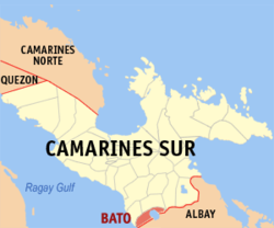
Map of Camarines Sur with Bato highlighted
Members
- Josebello Y. Buquid
- Diosdado T. Zorilla
- Martin G. Batacan
- Noel C. Tino
- Alvin O. Sacueza
- Adolfa A. Ramos, Jr.
- Noel C. Tuyay
- Erwin Nestor O. Rempola
(2020 census)[3]
30.85
4435
051703000
Central Bikol
Tagalog
Bato, officially the Municipality of Bato (Rinconada Bikol: Banwāan ka Bato; Tagalog: Bayan ng Bato), is a 3rd class municipality in the province of Camarines Sur, Philippines. According to the 2020 census, it has a population of 52,155 people.[3]
The municipality of Bato, like Buhi town, is home to a lake teeming with various kinds of fishes. Sinarapan, the world's smallest commercially harvested fish, occupies the waters of Lake Bato. Also present, the lake abounds with tilapia housed in fish cages.
Bato is 26 kilometres (16 mi) from Pili and 476 kilometres (296 mi) from Manila.
History
This town was formerly called as "Kaliligno" or "Caliligno" named by the natives that settled along the river area.
This small village later was elevated into a status of a town under the decree of Spanish Superior Government on February 15, 1753. Years back, a parish was already existing which was also made under the same decree. This parish adopted "The Most Holy Trinity" as its patron saint. Its feast day is celebrated every Sunday after the Pentecost. The Bato is also known for its best noodles called Pansit Bato.
Geography
Barangays
Bato is politically subdivided into 33 barangays. Each barangay consists of puroks and some have sitios.
- Agos
- Bacolod
- Buluang
- Caricot
- Cawacagan
- Cotmon
- Cristo Rey
- Del Rosario
- Divina Pastora (Poblacion)
- Goyudan
- Lobong
- Lubigan
- Mainit
- Manga (Mangga)
- Masoli
- Neighborhood
- Niño Jesus
- Pagatpatan
- Palo
- Payak
- Sagrada (Sagrada Familia)
- Salvacion
- San Isidro
- San Juan
- San Miguel
- San Rafael (Poblacion)
- San Roque
- San Vicente
- Santa Cruz (Poblacion)
- Santiago (Poblacion)
- Sooc
- Tagpolo
- Tres Reyes (Poblacion)
Climate
| Climate data for Bato, Camarines Sur | |||||||||||||
|---|---|---|---|---|---|---|---|---|---|---|---|---|---|
| Month | Jan | Feb | Mar | Apr | May | Jun | Jul | Aug | Sep | Oct | Nov | Dec | Year |
| Mean daily maximum °C (°F) | 33 (91) | 32 (90) | 35 (95) | 37 (99) | 37 (99) | 36 (97) | 35 (95) | 33 (91) | 35 (95) | 34 (93) | 33 (91) | 32 (90) | 34 (94) |
| Mean daily minimum °C (°F) | 26 (79) | 26 (79) | 28 (82) | 30 (86) | 31 (88) | 31 (88) | 29 (84) | 28 (82) | 29 (84) | 28 (82) | 28 (82) | 27 (81) | 28 (83) |
| Average precipitation mm (inches) | 51.03 (2.01) | 78.13 (3.08) | 55.3 (2.18) | 83.07 (3.27) | 159.34 (6.27) | 239.88 (9.44) | 385.8 (15.19) | 391.75 (15.42) | 293.65 (11.56) | 401.33 (15.80) | 108.2 (4.26) | 334.9 (13.19) | 2,582.38 (101.67) |
| Average rainy days | 21 | 24 | 19 | 20 | 25 | 29 | 31 | 29 | 29 | 29 | 27 | 30 | 313 |
| Source: World Weather Online[5] | |||||||||||||
Demographics
|
|
| ||||||||||||||||||||||||||||||||||||||||||||||||||||||
| Source: Philippine Statistics Authority[6][7][8][9] | ||||||||||||||||||||||||||||||||||||||||||||||||||||||||
In the 2020 census, the population of Bato, Camarines Sur, was 52,155 people,[3] with a density of 490 inhabitants per square kilometre or 1,300 inhabitants per square mile.
Only about 58.27% of the household population is considered as literate.
Mother tongue of the majority is Riŋkonāda also known as Bikol Rinconada, one of the languages of Bicol region. The population speaks a different form of Rinconada Bikol called Bato variant, a lowland dialect (sinaranəw). Natives are also conversant with Coastal Bikol, Filipino/Tagalog and English languages.
Religion

- Roman Catholicism is the predominant religion, followed by the Iglesia ni Cristo as the largest minority.
- Other religious denominations include Church of Jesus Christ of Latter Day Saints; United Churches of Christ in the Philippines Seventh Day Adventist; Bible Baptist; Born Again; Jehovah's Witnesses; Protestants; Aglipay and Islam.
- There are three (3) Catholic Churches in Bato.
Economy
Poverty Incidence of Bato
Graphs are unavailable due to technical issues. There is more info on Phabricator and on MediaWiki.org. |
Majority of employment is within agriculture, fishery, poultry and construction industry groups.[17]
- Commerce and industry
- 96 commercial establishments engaged in retail trade
- 46 commercial establishments engaged in services
- 1 commercial establishment engaged in real estate - MTBK Co.
- 1 engaged in banking and finance
- 31 industrial establishments
- 2 Hotels - Casa de Piedra and MTBK Hotel
Natural resources include clams, pearls, local shrimps, tabios, and tilapia, particularly within Lake Bato; forest products such as anahaw leaves and local bamboo; non-metallic mineral resources such as white clay among others.
- Agriculture Sector
- 78.087 square kilometers of Agricultural Lands devoted to crop production
- Rice, corn, coconut, root crops, vegetables, and fruit-bearing trees.
- Numerous farm and poultry products found
Local government
The list of the incumbent and former officials of the Municipality of Bato is the following:[18]
2022 - Present:
- Mayor: Domingo L. Zorilla Jr
- Vice-Mayor: Victorio S. Ramos
- Councilors:
- Josebello Buquid
- Martin G. Batacan
- Noel C. Tino
- Alvin O. Sacueza
- Adolfo F. Ramos Jr.
- Noel C. Tuyay
- Erwin Nestor O. Rempola
2019-2022:[19]
- Mayor: Hon. Francisco B. Bernaldez
- Vice-Mayor: Hon. Domingo L. Zorilla Jr.
- Councilors:
- Diosdado T. Zorilla
- Dominici G. Batacan
- Elizabeth Doctolero
- Ignacio L. Hugo
- Jose Samar
- Ban-Ban Aguila
- Matilde Sandrino
- Noel C. Tino
2016-2019:[20]
- Mayor: Hon. Francisco B. Bernaldez
- Vice-Mayor: Hon. Victorio S. Ramos
- Councilors:
- Diosdado T. Zorila
- Domingo L. Zorilla Jr.
- Martin G. Batacan
- Darwin Doctolero
- Edgar R. Argarin
- Nestor A. Orasa
- Danilo S. Mata
- Ignacio L.Hugo
List of former Municipal Mayors
This list is incomplete; you can help by adding missing items. (March 2023) |
- Paulino Calleja (1860)
Tourism

- Cotmon Falls
- Arbin Beach Resort
- Lake Bato
- Most Holy Trinity Parish Church
Infrastructure
Health
- Municipal Health Center and Barangay Health Stations total bed capacity: Eight (8) beds
- Health personnel numbers only about seventeen (17)
Security

Facilities for police protection include Police Station Headquarters near the Municipal Hall in the Poblacion, Police Substation in Barangay Tres Reyes, Police Outpost in Barangay San Miguel. The bureau of Fire Protection of Bato has about eleven (11) firemen personnel.
Transportation
- 19.550 kilometres (12.148 mi) of National Roads
- 45.650 kilometres (28.366 mi) of Provincial Road
- 7.206 kilometres (4.478 mi) of municipal roads
- 38.683 kilometres (24.037 mi) of Barangays Roads
- six (6) bridges
- 235 privately owned vehicles
- public utility vehicles and government vehicles
Utilities
Water supply is provided on 3 levels:
- Level I: wells, springs, or water peddlers common in rural barangays and households
- Level II: communal faucet system
- Level III: Bato Water District provides Level III Water Supply Service generally within the poblacion only
Power and electricity:
- Camarines Sur Electric Cooperative (CASURECO) which provides retails electrical supply to the municipality and maintains a substation
- Domestic Consumptions
- 95.18% with total average consumption rate of 35,595.40 KWH/month Industrial and Commercial Consumption have only about 0.48% connections
- Public buildings, streetlights and other account for the remaining 1.72% number of consumption
Communication facilities include telephone/cellular services, postal services, telegraph services, cable television services, and print and broadcast media services.
Education

Private school institutions:
- Holy Trinity College of Cam. Sur
- Mataas na Paaralan ng Pagatpatan
- Saint John the Baptist Institute of Bicol Inc.
- Ocampo Academy Technological Institute.
- Taburnal Learning Center
- Modern Learning Center
- Verbum Dei School
15 public elementary schools:
- Bato North Central School
- Bato South Central School
- San Vicente Elementary School
- San Miguel Elementary School
- Agos Elementary School
- Nino Jesus Elementary School
- Masoli Elementary School
- San Roque Elementary School
- Atipolo Elementary School
- Carlos Nardo Elementary School
- Manga Elementary School
- Palo Elementary School
- Buluang Elementary School
- Salvacion Elementary School
- Cristo Rey Elementary School
- Sagrada Elementary School
- Dr. Heracleo Guballo Elementary School
- Tagpolo Elementary School
5 public secondary schools:
- Bato National Highschool
- Masoli Highscool
- Salvacion National Highschool
- San Roque National Highschool
- Payak Highschool
1 public library:
- MTBK Divina Pastora Library
Notable personalities
- Maria Venus Raj - Binibining Pilipinas-Universe 2010 and placed 4th Runner-Up in Miss Universe 2010 pageant
References
- ^ Municipality of Bato | (DILG)
- ^ "2015 Census of Population, Report No. 3 – Population, Land Area, and Population Density" (PDF). Philippine Statistics Authority. Quezon City, Philippines. August 2016. ISSN 0117-1453. Archived (PDF) from the original on May 25, 2021. Retrieved July 16, 2021.
- ^ a b c Census of Population (2020). "Region V (Bicol Region)". Total Population by Province, City, Municipality and Barangay. Philippine Statistics Authority. Retrieved 8 July 2021.
- ^ "PSA Releases the 2018 Municipal and City Level Poverty Estimates". Philippine Statistics Authority. 15 December 2021. Retrieved 22 January 2022.
- ^ "Bato, Camarines Sur: Average Temperatures and Rainfall". World Weather Online. Retrieved 29 October 2017.
- ^ Census of Population (2015). "Region V (Bicol Region)". Total Population by Province, City, Municipality and Barangay. Philippine Statistics Authority. Retrieved 20 June 2016.
- ^ Census of Population and Housing (2010). "Region V (Bicol Region)" (PDF). Total Population by Province, City, Municipality and Barangay. National Statistics Office. Retrieved 29 June 2016.
- ^ Censuses of Population (1903–2007). "Region V (Bicol Region)". Table 1. Population Enumerated in Various Censuses by Province/Highly Urbanized City: 1903 to 2007. National Statistics Office.
{{cite encyclopedia}}: CS1 maint: numeric names: authors list (link) - ^ "Province of Camarines Sur". Municipality Population Data. Local Water Utilities Administration Research Division. Retrieved 17 December 2016.
- ^ "Poverty incidence (PI):". Philippine Statistics Authority. Retrieved December 28, 2020.
- ^ "Estimation of Local Poverty in the Philippines" (PDF). Philippine Statistics Authority. 29 November 2005.
- ^ "2003 City and Municipal Level Poverty Estimates" (PDF). Philippine Statistics Authority. 23 March 2009.
- ^ "City and Municipal Level Poverty Estimates; 2006 and 2009" (PDF). Philippine Statistics Authority. 3 August 2012.
- ^ "2012 Municipal and City Level Poverty Estimates" (PDF). Philippine Statistics Authority. 31 May 2016.
- ^ "Municipal and City Level Small Area Poverty Estimates; 2009, 2012 and 2015". Philippine Statistics Authority. 10 July 2019.
- ^ "PSA Releases the 2018 Municipal and City Level Poverty Estimates". Philippine Statistics Authority. 15 December 2021. Retrieved 22 January 2022.
- ^ municipal profile
- ^ "2022 ELECTION RESULTS: Bato, Camarines Sur".
- ^ "Bato - Camarines Sur | City/Municipality Results | Eleksyon 2019".
- ^ "Halalan 2016 - Partial and Unofficial Results".
External links
Wikimedia Commons has media related to Bato, Camarines Sur.
- Philippine Standard Geographic Code
- Philippine Census Information
- Official Site of the Province of Camarines Sur
- https://ph.rappler.com/elections/2022/camarines-sur/bato
Places adjacent to Bato, Camarines Sur | |
|---|---|


- v
- t
- e
 Province of Camarines Sur
- Naga (Administratively independent from the province but grouped under Camarines Sur by the Philippine Statistics Authority.)


