Blue Ridge, Houston

Blue Ridge is a community in Houston, Texas, United States that used to be a distinct unincorporated area in northeast Fort Bend County. The community, which was also known as Hobby, is located on a ridge of Oyster Creek, 16 miles (26 km) east of Richmond.[1] The section of Blue Ridge within the Houston City Limits is known as the Fort Bend-Houston Super Neighborhood #41.[2]
History
The area now known as Blue Ridge was a part of Stephen F. Austin's first colony. The site itself began to be permanently occupied in the late 19th century. As an independent community Blue Ridge did not have any post offices. The W. Allen Robinson family arrived in Blue Ridge in 1894, and in the 1890s the family established a ranch headquarters. Oil was discovered near Blue Ridge in 1919, and a salt mine opened shortly afterwards. In 1925 gas was discovered in the area. As resources were discovered, banks and gambling houses opened and the Handbook of Texas stated that Blue Ridge became a "boomtown".[1] In 1936 the 4,348-acre (1,760 ha) Blue Ridge State Prison Farm incorporated the area, and most Blue Ridge residents were staff members at the facility.[1] Blue Ridge acted as a satellite work camp for the Central Prison Farm.[3]
In 1958 the Texas Department of Corrections voted to sell the prison lands to private developers.[1] The houses were developed in the 1960s and 1970s. Parts of the area were annexed by Houston in the early 1970s.[4] The first population figure for the community was of the year 1970, when the community had 50 residents and no businesses.[1] The former prison inmate housing compound is the current location of Willowridge High School.
Cityscape
The Houston Fort Bend Super Neighborhood has its boundaries as Beltway 8, Fondren Road, Hiram Clarke Road, and McHard Road. Its area is almost 8 square miles (21 km2).[5] Many churches of various ethnic groups and religions are supported by the Blue Ridge community.[1] Carol E. Vaughn of the Houston Chronicle said that the 5-acre (2.0 ha) area, before the formation of the super neighborhood, "has considered itself a stepchild of sorts in the past, an area unwittingly passed back and forth between parents."[4] Half of the community has a Missouri City zip code (77489) west of Chimney Rock - a majority of residents still refer to this section as Missouri City even though it is not located inside the Missouri City city limits. Residents who still use the Missouri City designation are known as Missouri City by Choice residents.[citation needed]
Government
Blue Ridge is within Houston City Council District K.[6] Prior to 2011 it was a part of city council district D.[7]
In the final Mayor of Houston election before 2002, over 6,000 people there voted for Lee P. Brown.[4]
Transportation
Metropolitan Transit Authority of Harris County (METRO) operates public bus services.
In 1990 members of the Ridgegate and Briargate subdivisions protested proposed bus services from METRO.[8]
Education
Primary and secondary schools

Blue Ridge is within the Fort Bend Independent School District. The community is within the East Division, controlling school board slots 5 through 7.[9] As of 2008 the board members in the slots are Laurie Caldwell, Steve Smelley, and David Reitz, respectively.[10] As an independent community Blue Ridge did not have any schools.[1]
Zoned schools include:
- Briargate-Blue Ridge Elementary School
- Ridgegate Elementary School
- Ridgemont Elementary School
- Christa McAuliffe Middle School
- Willowridge High School
Blue Ridge Elementary School was occupied in August 1969. Ridgemont was occupied in August 1973. Briargate was occupied in the fall of 1977. Willowridge's phase one began construction in February 1978 and opened in September 1979. Ridgegate was occupied in January 1981. McAuliffe was occupied in the northern hemisphere fall of 1986. Phase two of Willowridge was completed in the summer of 1992.[11] Blue Ridge and Briargate elementaries consolidated in 2023, with a new campus being built on the Briargate location,[12] due to decreased enrollments.[13]
Public libraries

The Stimley-Blue Ridge Library of the Houston Public Library is located at 7007 West Fuqua in Blue Ridge.[14] In 1997 the library was named after Sherman E. Stimley, the first African-American law associate of the firm Vinson & Elkins. In 1985 Stimley started the first consulting company exclusively dealing with tax-exempt bond law that was headed by an African-American in Houston.[15] Stimley had books as an interest.[16]
Parks and recreation
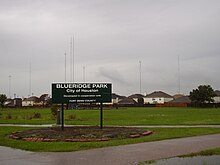
The Blueridge Park, operated by the City of Houston's Parks and Recreation Department, is in Blue Ridge.[17] Fort Bend County operates the Post Oak Park. The 23-acre (93,000 m2) park includes three baseball fields, one concession stand, one softball field, and one toilet facility.[18]
See also
 Texas portal
References
- ^ a b c d e f g Blue Ridge, Texas from the Handbook of Texas Online - Retrieved on July 17, 2010
- ^ "Super Neighborhood No. 41 Resource Assessment" (PDF). City of Houston. Retrieved 2020-06-01. - Map attached.
- ^ "Texas correctional officer killed in 1936 recognized at memorial ceremony Archived February 20, 2011, at the Wayback Machine." Texas Department of Criminal Justice. May–June 2007. Retrieved on May 1, 2011.
- ^ a b c Vaughn, Carol E. "Neighborhood councils recognized / Fort Bend to develop identity."[dead link] Houston Chronicle. Thursday June 20, 2002. ThisWeek 1. Retrieved on October 27, 2011. Available from the Houston Public Library newspaper database, accessible with a library card and password.
- ^ De Mangin, Charles. "Neighborhood charts its course." Houston Chronicle. Thursday November 14, 2002. Retrieved on October 27, 2011. Available from the Houston Public Library website, accessible with a library card number and PIN
- ^ City of Houston, Council District Maps, District K Archived 2012-12-24 at the Wayback Machine." City of Houston. Retrieved on November 5, 2011.
- ^ "City of Houston Council District "D"." City of Houston. April 3, 2003. Retrieved on November 7, 2011.
- ^ Roth, Bennett, "Suburban dream coming to an end?/Ridgegate residents battling buses." Houston Chronicle. Monday April 26, 1990. A11. Retrieved on October 26, 2011.
- ^ "2007-2008 Operating Procedures Archived 2008-12-09 at the Wayback Machine." Fort Bend Independent School District. Retrieved on December 8, 2008.
- ^ "Contacting Your School Board Members Archived 2008-12-04 at the Wayback Machine." Fort Bend Independent School District. Retrieved on December 8, 2008.
- ^ "FBISD History Archived 2008-09-07 at the Wayback Machine." Fort Bend Independent School District. Retrieved on April 4, 2010.
- ^ "Fort Bend ISD Board approves construction managers for elementary school rebuilds as part of 2023 Bond package (6/27/2023)". Fort Bend Independent School District. Retrieved 2023-11-29.
- ^ "BRIARGATE ELEMENTARY REBUILD (Prop A)". Fort Bend Independent School District. Retrieved 2023-11-29.
- ^ "Stimley-Blue Ridge Neighborhood Library Archived October 18, 2008, at the Wayback Machine." Houston Press. Retrieved on December 8, 2008.
- ^ Siegel, Joshua. "Celebrating Black History Month Engineer-turned-lawyer Sherman Stimley." Houston Chronicle. February 9, 2011. Retrieved on July 11, 2011.
- ^ "Stimley-Blue Ridge Neighborhood Library". Houston Public Library. Retrieved 2022-07-03.
3810 West Fuqua Street|Houston, TX 77489
- ^ "Our Parks A-F Archived 2010-06-20 at the Wayback Machine." City of Houston. Retrieved on October 9, 2009.
- ^ "Leased Parks Archived 2009-12-21 at the Wayback Machine." Fort Bend County. Retrieved on October 11, 2009.
External links
- Blue Ridge, Texas from the Handbook of Texas Online
- v
- t
- e
 City of Houston
Nickname: Space City

- Anime Matsuri
- Art Car Parade
- Astroworld Festival
- Bayou Place
- Buffalo Bayou Park
- Comicpalooza
- Discovery Green
- Downtown Aquarium
- The Galleria
- Hermann Park
- Houston Livestock Show and Rodeo
- Houston Zoo
- Kemah Boardwalk
- Lee and Joe Jamail Skatepark
- Memorial Park
- Museum District
- The Orange Show
- San Jacinto Battleground State Historic Site
- Space Center Houston
- Splashtown
- Theater District
- Waterwall Park
districts
- Acres Homes
- Addicks
- Alief
- Almeda
- Bordersville
- Boulevard Oaks
- Braeburn
- Braeswood Place
- Brays Oaks
- Briargrove
- Blue Ridge
- Chinatown
- Clear Lake City
- Denver Harbor
- East Downtown
- East End
- East Houston
- Fairbanks
- Five Corners
- Forum Park
- Genoa
- Glenbrook Valley
- Gulfton
- Harrisburg
- Hiram Clarke
- Houston Heights
- Independence Heights
- Inwood Forest
- Kingwood
- Link Valley
- Lower Westheimer
- Magnolia Park
- Mahatma Gandhi District
- Maplewood
- Memorial
- Meyerland
- Midtown
- Montrose District
- Museum District
- Neartown
- Near Northwest
- North Shore
- Northside
- Oak Forest
- River Oaks
- Riverside Terrace
- Southwest Management District
- South Park
- Spring Branch
- Sunnyside
- Upper Kirby
- Health institutions
- Baylor College of Medicine
- UH College of Medicine
- UTHealth
- MD Anderson Cancer Center
- Texas A&M Health Science Center
- State universities
- University of Houston
- University of Houston–Clear Lake
- University of Houston–Downtown
- Texas Southern University
- Private universities
- Houston Christian University
- Rice University
- University of St. Thomas
- Community colleges
- Houston Community College
- Lone Star College
- San Jacinto College
- Lee College
- Afton Oaks
- Brentwood
- Briargrove Park
- Briarhills
- Broadacres
- City Park
- Clinton Park
- Cloverland
- Corinthian Pointe
- Cottage Grove
- Crestwood/Glen Cove
- Eastwood
- Garden Oaks
- Glenshire
- Highland Village
- Houston Gardens
- Idylwood
- Kashmere Gardens
- Knollwood Village
- Lakes of Parkway
- Larchmont
- Magnolia Grove
- Montrose
- Morningside Place
- Near North Side
- Nottingham Forest
- Old Braeswood
- Parkway Villages
- Pecan Park
- Port Houston
- Rice Military
- Richmond Strip
- Robindell
- Royal Oaks Country Club
- Sagemont
- Scenic Woods
- Settegast
- Shadyside
- Sharpstown
- Shenandoah
- Somerset Green
- Southampton
- Southbelt/Ellington
- Southcrest
- Southgate
- Stablewood
- St. George Place (Lamar Terrace)
- Sunset Heights
- Sunset Terrace/Montclair
- Tanglewood
- University Oaks
- Village at Glen Iris
- Walnut Bend
- Westbury
- West End
- West Oaks
- Westwood (subdivision)
- Westmoreland
- Willow Meadows
- Willowbend
- Windsor Village
- Woodland Heights
 Category
  Texas portal
29°36′00″N 95°28′48″W / 29.600°N 95.480°W / 29.600; -95.480


