Bokod, Benguet
Municipality in Benguet, Philippines
Municipality in Cordillera Administrative Region, Philippines

Flag

Seal

Map of Benguet with Bokod highlighted
(2020 census)[3]
9.88
2605
141104000
Kankanaey
Ibaloi
Kallahan
Ilocano
Tagalog
Bokod, officially the Municipality of Bokod, (Ilocano: Ili ti Bokod; Tagalog: Bayan ng Bokod), is a 4th class municipality in the province of Benguet, Philippines. According to the 2020 census, it has a population of 14,435 people.[3]
History
Pre-colonial and Spanish periods
According to folklore, Bokod, once a heavily forested village, got its name from a man named Ebokot (or Ekbot), who introduced agricultural development to the area.[5] Ebokot's name was associated with the village and was registered as a pueblo during the Spanish Regime.[6]
American period
Bokod was established as one of the 19 townships of Benguet during the American Rule with the enactment of Act No. 48 on November 22, 1900.[5][6][7][8]
On August 13, 1908, Benguet was established as a sub-province of the newly created Mountain Province with the enactment of Act No. 1876. As a result, six townships of Benguet were abolished, among them were Ambuklao and Daclan which were integrated into the township of Bokod.[5][6][8]
Post-war era
One of the principal infrastructure in Bokod is the Ambuklao Dam. Built in 1950 and opened in 1956, it is one of the most important hydroelectric facilities in Luzon.
On June 25, 1963, President Diosdado Macapagal issued Executive Order No. 42 converting eight (8) of the thirteen (13) towns (designated as municipal districts) of Benguet sub-province into regular municipalities. Bokod was among them.[9]
On June 18, 1966, the sub-province of Benguet was separated from the old Mountain Province and was converted into a regular province. Bokod remained to be a component municipality of the newly established province.[10]
Geography
Bokod is located at 16°29′29″N 120°49′48″E / 16.4914°N 120.83°E / 16.4914; 120.83. It is bounded by Kabayan on the north-east, Atok on the north-west, Tublay on the mid-west, Itogon on the south-west, and Kayapa on the east.
According to the Philippine Statistics Authority, the municipality has a land area of 274.96 square kilometres (106.16 sq mi) [11] constituting 9.93% of the 2,769.08-square-kilometre- (1,069.15 sq mi) total area of Benguet.
Bokod is 53 kilometres (33 mi) from Baguio, 58 kilometres (36 mi) from La Trinidad, and 303 kilometres (188 mi) from Manila.
Barangays

Bokod is politically subdivided into 10 barangays.[12] Each barangay consists of puroks and some have sitios.
| PSGC | Barangay | Population | ±% p.a. | |||
|---|---|---|---|---|---|---|
| 2020[3] | 2010[13] | |||||
| 141104001 | Ambuclao | 22.9% | 3,301 | 3,013 | ▴ | 0.92% |
| 141104002 | Bila | 10.3% | 1,484 | 991 | ▴ | 4.12% |
| 141104003 | Bobok‑Bisal | 8.6% | 1,246 | 1,086 | ▴ | 1.38% |
| 141104004 | Daclan | 12.1% | 1,748 | 1,748 |  | 0.00% |
| 141104005 | Ekip | 6.7% | 962 | 806 | ▴ | 1.78% |
| 141104006 | Karao | 7.7% | 1,111 | 958 | ▴ | 1.49% |
| 141104007 | Nawal | 4.2% | 605 | 743 | ▾ | −2.03% |
| 141104008 | Pito | 7.4% | 1,065 | 838 | ▴ | 2.43% |
| 141104009 | Poblacion | 16.0% | 2,314 | 1,964 | ▴ | 1.65% |
| 141104010 | Tikey | 4.1% | 599 | 501 | ▴ | 1.80% |
| Total | 14,435 | 14,435 | | 0.00% | ||
Climate
| Climate data for Bokod, Benguet | |||||||||||||
|---|---|---|---|---|---|---|---|---|---|---|---|---|---|
| Month | Jan | Feb | Mar | Apr | May | Jun | Jul | Aug | Sep | Oct | Nov | Dec | Year |
| Mean daily maximum °C (°F) | 23 (73) | 24 (75) | 26 (79) | 27 (81) | 27 (81) | 26 (79) | 25 (77) | 24 (75) | 25 (77) | 25 (77) | 25 (77) | 23 (73) | 25 (77) |
| Mean daily minimum °C (°F) | 14 (57) | 15 (59) | 16 (61) | 18 (64) | 20 (68) | 20 (68) | 20 (68) | 20 (68) | 19 (66) | 18 (64) | 16 (61) | 15 (59) | 18 (64) |
| Average precipitation mm (inches) | 21 (0.8) | 28 (1.1) | 34 (1.3) | 58 (2.3) | 160 (6.3) | 179 (7.0) | 226 (8.9) | 225 (8.9) | 215 (8.5) | 168 (6.6) | 59 (2.3) | 32 (1.3) | 1,405 (55.3) |
| Average rainy days | 7.5 | 8.5 | 10.9 | 14.9 | 23.9 | 25.7 | 26.7 | 25.3 | 24.9 | 18.9 | 11.8 | 8.9 | 207.9 |
| Source: Meteoblue[14] | |||||||||||||
Demographics
| Year | Pop. | ±% p.a. |
|---|---|---|
| 1903 | 31 | — |
| 1918 | 4,268 | +38.86% |
| 1939 | 6,082 | +1.70% |
| 1948 | 5,503 | −1.11% |
| 1960 | 8,946 | +4.13% |
| 1970 | 10,161 | +1.28% |
| 1975 | 10,404 | +0.48% |
| 1980 | 11,899 | +2.72% |
| 1990 | 11,474 | −0.36% |
| 1995 | 10,526 | −1.60% |
| 2000 | 11,705 | +2.30% |
| 2007 | 12,913 | +1.36% |
| 2010 | 12,648 | −0.75% |
| 2015 | 13,756 | +1.61% |
| 2020 | 14,435 | +0.95% |
| Source: Philippine Statistics Authority[15][13][16][17] | ||
In the 2020 census, Bokod had a population of 14,435.[3] The population density was 52 inhabitants per square kilometre (130/sq mi).
Economy
Poverty Incidence of Bokod
Graphs are unavailable due to technical issues. There is more info on Phabricator and on MediaWiki.org. |
Government
Local government
Bokod, belonging to the lone congressional district of the province of Benguet, is governed by a mayor designated as its local chief executive and by a municipal council as its legislative body in accordance with the Local Government Code. The mayor, vice mayor, and the councilors are elected directly by the people through an election which is being held every three years.
Elected officials
| Position | Name | ||
|---|---|---|---|
| Congressman | Eric Go Yap
| Mayor | Thomas K. Wales Jr. |
| Vice-Mayor | Erik Donn Ignacio | ||
| Councilors | Miguel G. Cosalan, Jr. | ||
| Doroteo S. Beray | |||
| Marian D. Calawen | |||
| Elinger G. Dayotao | |||
| Arthur L. Solano | |||
| Johnny A. Sama | |||
| Alejandro C. Basilio | |||
| Sonny E. Olas |
Attractions
- Ambuklao Dam
- Mount Amalkatan
- Badekbek Sulfur Springs
- Palansa Panoramic View
- Bila Mountain Saddle
- Ekip Mossy Forest
- Palpalan Waterfalls
- Adwagan River
- Bobbok Second Growth Pine Forests
- Mount Pulag
- Mount Purgatory
- Mount Patoktok
Education
Public schools
As of 2014, Bokod has 37 public elementary schools and 3 public secondary schools.[25][26][27]

|
|
Universities
- Benguet State University Bokod Campus (BSAT) (Ambangeg)
Private schools
- Immaculate Conception School of Bokod, Inc. (Poblacion)
Gallery
-
 Municipal hall
 -
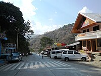
 Downtown Bokod
 -
 Immaculate Conception Parish Church
 -
 A road in town
 -
 Pine forests in Bokod


Notes
References
- ^ Municipality of Bokod | (DILG)
- ^ "2015 Census of Population, Report No. 3 – Population, Land Area, and Population Density" (PDF). Philippine Statistics Authority. Quezon City, Philippines. August 2016. ISSN 0117-1453. Archived (PDF) from the original on May 25, 2021. Retrieved July 16, 2021.
- ^ a b c d Census of Population (2020). "Cordillera Administrative Region (CAR)". Total Population by Province, City, Municipality and Barangay. Philippine Statistics Authority. Retrieved 8 July 2021.
- ^ "PSA Releases the 2018 Municipal and City Level Poverty Estimates". Philippine Statistics Authority. 15 December 2021. Retrieved 22 January 2022.
- ^ a b c "Municipality of Bokod". Province of Benguet (official website). Archived from the original on 11 November 2014. Retrieved 19 January 2021.
- ^ a b c "Municipality of Bokod, Benguet". Department of the Interior and Local Government - Cordillera Administrative Region. Archived from the original on 7 October 2014. Retrieved 1 November 2014.
- ^ "Facts & Figures: Benguet Province". Philippine Statistics Authority - National Statistical Coordination Board - Cordillera Administrative Region. Archived from the original on 28 February 2016. Retrieved 19 January 2021.
- ^ a b "History: Benguet Province". Province of Benguet (official website). Archived from the original on 19 October 2014. Retrieved 19 January 2021.
- ^ "Executive Order No. 42, s. 1963: Declaring Certain Municipal Districts in the Philippines as Municipalities". Official Gazette of the Republic of the Philippines. 25 June 1963. Retrieved 19 January 2021.
- ^ "Republic Act No. 4695: An Act Creating the Provinces of Benguet, Mountain Province, Ifugao and Kalinga-Apayao". Chan Robles Virtual Law Library. 18 June 1966. Archived from the original on 4 March 2016. Retrieved 12 December 2016.
- ^ "Province: Benguet". PSGC Interactive. Quezon City, Philippines: Philippine Statistics Authority. Retrieved 12 November 2016.
- ^ "Municipal: Bokod, Benguet". PSGC Interactive. Quezon City, Philippines: Philippine Statistics Authority. Retrieved 8 January 2016.
- ^ a b Census of Population and Housing (2010). "Cordillera Administrative Region (CAR)" (PDF). Total Population by Province, City, Municipality and Barangay. National Statistics Office. Retrieved 29 June 2016.
- ^ "Bokod: Average Temperatures and Rainfall". Meteoblue. Retrieved 21 March 2020.
- ^ Census of Population (2015). "Cordillera Administrative Region (CAR)". Total Population by Province, City, Municipality and Barangay. Philippine Statistics Authority. Retrieved 20 June 2016.
- ^ Censuses of Population (1903–2007). "Cordillera Administrative Region (CAR)". Table 1. Population Enumerated in Various Censuses by Province/Highly Urbanized City: 1903 to 2007. National Statistics Office.
{{cite encyclopedia}}: CS1 maint: numeric names: authors list (link) - ^ "Province of Benguet". Municipality Population Data. Local Water Utilities Administration Research Division. Retrieved 17 December 2016.
- ^ "Poverty incidence (PI):". Philippine Statistics Authority. Retrieved December 28, 2020.
- ^ "Estimation of Local Poverty in the Philippines" (PDF). Philippine Statistics Authority. 29 November 2005.
- ^ "2003 City and Municipal Level Poverty Estimates" (PDF). Philippine Statistics Authority. 23 March 2009.
- ^ "City and Municipal Level Poverty Estimates; 2006 and 2009" (PDF). Philippine Statistics Authority. 3 August 2012.
- ^ "2012 Municipal and City Level Poverty Estimates" (PDF). Philippine Statistics Authority. 31 May 2016.
- ^ "Municipal and City Level Small Area Poverty Estimates; 2009, 2012 and 2015". Philippine Statistics Authority. 10 July 2019.
- ^ "PSA Releases the 2018 Municipal and City Level Poverty Estimates". Philippine Statistics Authority. 15 December 2021. Retrieved 22 January 2022.
- ^ "Masterlist of Public Elementary Schools for the School year 2012- 2013". Department of Education (Philippines), July 15, 2013. Archived from the original (XLSX) on 4 March 2016. Retrieved 28 December 2014.
- ^ a b "Masterlist of Secondary Schools (School Year 2013- 2014)". Department of Education (Philippines), July 4, 2013. Archived from the original (XLSX) on 1 July 2014. Retrieved 20 November 2014.
- ^ a b "Masterlist of Public Schools SY 2013-2014". Department of Education (Philippines), 22 October 2014. Archived from the original (XLSX) on 21 April 2016. Retrieved 28 December 2014.
External links
![]() Media related to Bokod, Benguet at Wikimedia Commons
Media related to Bokod, Benguet at Wikimedia Commons
- Philippine Standard Geographic Code
Places adjacent to Bokod, Benguet | |
|---|---|


- v
- t
- e
 Province of Benguet
- Baguio (Administratively independent from the province but grouped under Benguet by the Philippine Statistics Authority.)
| Authority control databases |
|
|---|


