Bratków, Lower Silesian Voivodeship
Village in Lower Silesian Voivodeship, Poland
51°00′15″N 14°56′40″E / 51.00417°N 14.94444°E / 51.00417; 14.94444 Poland
Bratków [ˈbratkuf] is a village in the administrative district of Gmina Bogatynia, within Zgorzelec County, Lower Silesian Voivodeship, in south-western Poland.[1] It is located in a Polish salient between the Czech Republic and Germany.
It lies approximately 10 kilometres (6 mi) north of Bogatynia, 17 kilometres (11 mi) south of Zgorzelec, and 148 kilometres (92 mi) west of the regional capital Wrocław.
History
In the Early Middle Ages, Bratków was a stronghold of the Bieżuńczanie tribe,[2] one of the Polish tribes.[3] Since the 11th century, the settlement was under Polish, Czech, Hungarian and Saxon rule, and from 1871 to 1945 it was also part of Germany. After the defeat of Germany in World War II in 1945, it became again part of Poland.
Gallery
-
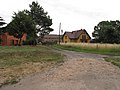
 Main road
 -
 Yellow house
 -
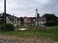 Village square


References
- ^ "Central Statistical Office (GUS) - TERYT (National Register of Territorial Land Apportionment Journal)" (in Polish). 2008-06-01.
- ^ Bena, Waldemar (2006). Szlakiem grodzisk słowiańskich i średniowiecznych zamków (in Polish and German). Zgorzelec. pp. 9–10.
{{cite book}}: CS1 maint: location missing publisher (link) - ^ "Plemiona polskie". Encyklopedia Internautica (in Polish). Retrieved 26 December 2020.
Wikimedia Commons has media related to Bratków, Lower Silesian Voivodeship.
- v
- t
- e

 | This Zgorzelec County location article is a stub. You can help Wikipedia by expanding it. |
- v
- t
- e


