Bridger Jack Butte
Rock formation in Utah, United States


Bridger Jack Butte
Location in Utah
Show map of Utah
Bridger Jack Butte
Bridger Jack Butte (the United States)
Show map of the United StatesSan Juan County, Utah, US
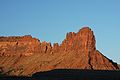
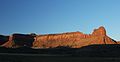
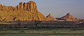
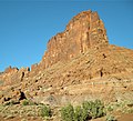
Bridger Jack Butte is a sandstone butte located in Bears Ears National Monument, in San Juan County, Utah, United States. Set at the northern tip of Bridger Jack Mesa and above the confluence of Indian and Lavender Creeks, the summit rises to an elevation of 5,890 feet (1,800 meters), and towers over 700 feet (210 meters) above the surrounding terrain and floor of Lavender Canyon to its west.[3] This landmark is situated four miles southeast of the Sixshooter Peaks, and is visible from State Route 211 between Newspaper Rock and the Needles District of Canyonlands National Park. "Bridger Jack" was a Paiute medicine man.[4]
Geology
Bridger Jack Butte is composed of hard, fine-grained Wingate Sandstone, the petrified remains of wind-borne sand dunes deposited approximately 200 million years ago in the Late Triassic. This Wingate Sandstone forms steep cliffs as it overlays softer layers of the Chinle Formation.[5] The next layer below this is the Moenkopi Formation.[6] Precipitation runoff drains into nearby Indian Creek, which is part of the Colorado River drainage basin.
Climbing
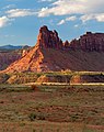
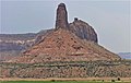
Bridger Jack Butte is set in the popular Indian Creek climbing area. The first ascent of Bridger Jack Butte was made June 12, 1983, by Ed Webster, Leonard Coyne, and Ellen Figi, via the Wild Flower route.[7] The "Bridger Jacks" are towers on the connecting ridge between the mesa and the butte. They have names such as "King of Pain", "Hummingbird Spire", "Sunflower Tower", "Easter Island", and "Thumbelina".[2]
Climbing routes on Bridger Jack Butte:
- Wild Flower – class 5.10a (3 pitches)[8]
- Sparkling Touch – class 5.11
- The Kokanee Corner – class 5.13+
- Hydrophobic coyote – class 5.10-
- Rites of Passage – class 5.11+
Climate
Spring and fall are the most favorable seasons to visit Bridger Jack Butte. According to the Köppen climate classification system, it is located in a cold semi-arid climate zone, which is defined by the coldest month having an average mean temperature below 32 °F (0 °C), and at least 50% of the total annual precipitation being received during the spring and summer.[9] This desert climate receives less than 10 inches (250 millimeters) of annual rainfall, and snowfall is generally light and transient during the winter.
Gallery
-
 Bridger Jacks and Butte, from east
 -
 Bridger Jacks and Butte, from east
 -
 Northwest aspect
 -
 Bridger Jack Butte, north aspect
 -
 Bridger Jack Mesa and Butte (right)
 -
 Bridger Jack Butte (left) with Sixshooter Peaks (right)
 -


See also
References
- ^ "Bridger Jack Butte, Utah". Peakbagger.com. Retrieved 2020-11-08.
- ^ a b c d e f ""Bridger Jack Butte" - 6,100' UT". listsofjohn.com. Retrieved 2020-11-08.
- ^ "Bridger Jack Mesa". Geographic Names Information System. United States Geological Survey, United States Department of the Interior. Retrieved 2020-11-08.
- ^ John W. Van Cott, Utah Place Names: A Comprehensive Guide to the Origins of Geographic Names, University of Utah Press, 1990, page 49.
- ^ S.W. Lohman, The Geologic Story of Canyonlands National Park, US Government Printing Office, 1974, page 61.
- ^ J.H. Stewart, Stratigraphy and Origin of the Chinle Formation and Related Upper Triassic Strata in the Colorado Plateau Region, US Government Printing Office, 1972, page 296.
- ^ "First Ascent Timeline". DesertTowersBook.
- ^ "Rock Climbing in The Bridger Jacks, Indian Creek". mountainproject.com. Retrieved 2020-11-09.
- ^ Peel, M. C.; Finlayson, B. L.; McMahon, T. A. (2007). "Updated world map of the Köppen−Geiger climate classification". Hydrol. Earth Syst. Sci. 11. ISSN 1027-5606.
External links
- The Bridger Jacks Rock Climbing: Mountainproject.com
- Weather forecast: National Weather Service
- Bridger Jacks aerial video: Vimeo


