Cairo, Oklahoma
Unincorporated community in Oklahoma, United States
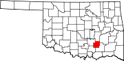
35°34′26″N 96°07′55″W / 35.57389°N 96.13194°W / 35.57389; -96.13194Cairo is an unincorporated community in Coal County, Oklahoma, United States.[1] It is located seven miles northeast of Coalgate.[2] The community was named after the town of Cairo, Illinois.[2] A post office operated in Cairo from March 28, 1902, to July 15, 1939.[2]
References
- ^ a b c U.S. Geological Survey Geographic Names Information System: Cairo, Oklahoma
- ^ a b c Shirk, George. Oklahoma Place Names, 2nd ed. University of Oklahoma Press: Norman, Oklahoma. 1987. p.39.
- v
- t
- e
Municipalities and communities of Coal County, Oklahoma, United States
County seat: Coalgate
- Centrahoma
- Coalgate
- Lehigh
- Tupelo
communities
- Cairo
- Olney
‡This populated place also has portions in an adjacent county or counties
- Oklahoma portal
- United States portal
 | This Oklahoma state location article is a stub. You can help Wikipedia by expanding it. |
- v
- t
- e


