You can help expand this article with text translated from the corresponding article in French. (January 2022) Click [show] for important translation instructions.
|
Châteaudun | |
|---|---|
Subprefecture and commune | |
 Chateau | |
.svg) Coat of arms | |
Location of Châteaudun  | |
 Châteaudun  Châteaudun | |
| Coordinates: 48°04′18″N 1°20′19″E / 48.0717°N 1.3387°E | |
| Country | France |
| Region | Centre-Val de Loire |
| Department | Eure-et-Loir |
| Arrondissement | Châteaudun |
| Canton | Châteaudun |
| Government | |
| • Mayor (2020–2026) | Fabien Verdier[1] |
Area 1 | 28.48 km2 (11.00 sq mi) |
| Population (2022)[2] | 12,898 |
| • Density | 450/km2 (1,200/sq mi) |
| Time zone | UTC+01:00 (CET) |
| • Summer (DST) | UTC+02:00 (CEST) |
| INSEE/Postal code | 28088 /28200 |
| Elevation | 102–152 m (335–499 ft) (avg. 140 m or 460 ft) |
| 1 French Land Register data, which excludes lakes, ponds, glaciers > 1 km2 (0.386 sq mi or 247 acres) and river estuaries. | |
Châteaudun (French pronunciation: [ʃɑtodœ̃]) is a commune in the Eure-et-Loir department in northern France. It is a sub-prefecture of the department. It was the site of the Battle of Châteaudun during the Franco-Prussian War.
Geography
[edit]Châteaudun is located about 45 km northwest of Orléans, and about 50 km south-southwest of Chartres. It lies on the river Loir, a tributary of the Sarthe.
History
[edit]
Châteaudun (Latin Castrodunum), which dates from the Gallo-Roman period, was in the middle ages the capital of the County of Dunois.[3]
The streets, which radiate from a central square, have a uniformity due to the reconstruction of the town after fires in 1723 and 1870.[3]
Employment
[edit]The area is rich agricultural land, but a major local employer is the Châteaudun Air Base just to the east of the town, and much larger than the town itself.
Population
[edit]
|
| ||||||||||||||||||||||||||||||||||||||||||||||||||||||||||||||||||||||||||||||||||||||||||||||||||||||||||||||||||
| |||||||||||||||||||||||||||||||||||||||||||||||||||||||||||||||||||||||||||||||||||||||||||||||||||||||||||||||||||
| Source: EHESS[4] and INSEE (1968-2017)[5] | |||||||||||||||||||||||||||||||||||||||||||||||||||||||||||||||||||||||||||||||||||||||||||||||||||||||||||||||||||
Main sights
[edit]The town has a château, founded in the 10th century,[3] known for being the first on the road to Loire Valley from Paris. Châteaundun also has a museum, the "Musée des beaux arts et d'histoire naturelle". The museum is diverse, the most popular exhibition being the big collection of stuffed birds. In addition, there are often temporary exhibitions, recent examples including the war of Asia, ancient Egypt and insects.[6]
Churches
[edit]-
 Saint-Valérien
 -
 La Madeleine
 -
 Saint-Jean-de-la-Chaîne
 -
 Saint-Lubin ruins
 -
 Saint-Lubin ruins
 -
 Notre-Dame-du-Champdé chapel (now cemetery entrance)
 -
 La Boissière chapel
.jpg)
.jpg)
.jpg)
.jpg)


.jpg)
Medieval houses
[edit]-
 Cuirasserie street and Huileries street angle
 -
 Cuirasserie street and Huileries street angle
 -
 Louis Esnault house
 -
 Château's architects' house
 -
 Virgin's house
 -
 Virgin's house (detail)
.jpg)
.jpg)
.jpg)
.jpg)
.jpg)
.jpg)
Personalities
[edit]Châteaudun was the birthplace of:
- Pierre Guédron (1570–1620), composer
- Nicolas Chaperon (1612–1656) painter
- Edmond Modeste Lescarbault (1814), doctor and amateur astronomer
- Romain Feillu (1984) road racing cyclist
- Brice Feillu (1985) road racing cyclist
Twin towns - sister cities
[edit]Châteaudun is twinned with:[7]
 Arklow, Ireland
 Kroměříž, Czech Republic
 Marchena, Spain
 Schweinfurt, Germany
 Trois-Rivières, Canada
Gallery
[edit]-
 Châteaudun (Eure-et-Loir) Donjon and chapel of the château
 -
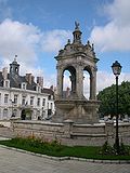 Fountain and façade of the town hall of Châteaudun
 -


Climate
[edit]| Climate data for Châteaudun (1991–2020 normals, extremes 1952–present) | |||||||||||||
|---|---|---|---|---|---|---|---|---|---|---|---|---|---|
| Month | Jan | Feb | Mar | Apr | May | Jun | Jul | Aug | Sep | Oct | Nov | Dec | Year |
| Record high °C (°F) | 15.7 (60.3) |
21.0 (69.8) |
25.4 (77.7) |
28.0 (82.4) |
32.1 (89.8) |
37.8 (100.0) |
41.7 (107.1) |
39.3 (102.7) |
35.2 (95.4) |
29.9 (85.8) |
21.7 (71.1) |
17.1 (62.8) |
41.7 (107.1) |
| Mean daily maximum °C (°F) | 7.1 (44.8) |
8.6 (47.5) |
12.6 (54.7) |
15.9 (60.6) |
19.4 (66.9) |
23.0 (73.4) |
25.8 (78.4) |
25.8 (78.4) |
21.8 (71.2) |
16.6 (61.9) |
10.9 (51.6) |
7.6 (45.7) |
16.3 (61.3) |
| Daily mean °C (°F) | 4.3 (39.7) |
4.8 (40.6) |
7.8 (46.0) |
10.4 (50.7) |
13.9 (57.0) |
17.3 (63.1) |
19.6 (67.3) |
19.6 (67.3) |
16.0 (60.8) |
12.1 (53.8) |
7.5 (45.5) |
4.7 (40.5) |
11.5 (52.7) |
| Mean daily minimum °C (°F) | 1.4 (34.5) |
1.0 (33.8) |
3.0 (37.4) |
4.8 (40.6) |
8.4 (47.1) |
11.6 (52.9) |
13.4 (56.1) |
13.3 (55.9) |
10.2 (50.4) |
7.6 (45.7) |
4.1 (39.4) |
1.8 (35.2) |
6.7 (44.1) |
| Record low °C (°F) | −18.8 (−1.8) |
−17.2 (1.0) |
−11.8 (10.8) |
−6.3 (20.7) |
−2.3 (27.9) |
1.2 (34.2) |
4.2 (39.6) |
3.6 (38.5) |
0.7 (33.3) |
−4.6 (23.7) |
−13.4 (7.9) |
−16.3 (2.7) |
−18.8 (−1.8) |
| Average precipitation mm (inches) | 51.5 (2.03) |
41.3 (1.63) |
44.2 (1.74) |
46.9 (1.85) |
56.1 (2.21) |
48.2 (1.90) |
51.9 (2.04) |
42.9 (1.69) |
42.7 (1.68) |
61.0 (2.40) |
55.1 (2.17) |
61.5 (2.42) |
603.3 (23.75) |
| Average precipitation days (≥ 1.0 mm) | 10.5 | 9.3 | 8.9 | 9.0 | 9.1 | 8.1 | 7.2 | 7.0 | 7.2 | 10.2 | 10.4 | 11.3 | 108.2 |
| Mean monthly sunshine hours | 64.8 | 91.9 | 144.2 | 188.7 | 215.6 | 226.4 | 237.7 | 233.0 | 186.6 | 121.1 | 72.7 | 63.0 | 1,845.7 |
| Source: Meteociel[8] | |||||||||||||
See also
[edit]References
[edit]- ^ "Répertoire national des élus: les maires". data.gouv.fr, Plateforme ouverte des données publiques françaises (in French). 2 December 2020.
- ^ "Populations de référence 2022" (in French). The National Institute of Statistics and Economic Studies. 19 December 2024.
- ^ a b c One or more of the preceding sentences incorporates text from a publication now in the public domain: Chisholm, Hugh, ed. (1911). "Châteaudun". Encyclopædia Britannica. Vol. 5 (11th ed.). Cambridge University Press. pp. 962–963.
- ^ Des villages de Cassini aux communes d'aujourd'hui: Commune data sheet Châteaudun, EHESS (in French).
- ^ Population en historique depuis 1968, INSEE
- ^ Museum website
- ^ "Villes en coopération". chambery.fr (in French). Châteaudun. Retrieved 20 November 2019.
- ^ "Normales et records pour Châteaudun (28)". Meteociel. Retrieved 20 November 2024.
External links
[edit]- Official website[usurped] (in French)
- Tourist office website Archived 26 September 2007 at the Wayback Machine (in English and French)
| International | |
|---|---|
| National | |
| Geographic | |
| Other | |