Cordeiro, Rio de Janeiro
Municipality in Southeast, Brazil

Flag
Seal
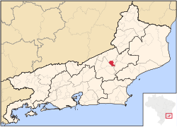
Location of Cordeiro in the state of Rio de Janeiro
 Brazil
 Rio de Janeiro
 (2020 [1])
Cordeiro (Portuguese pronunciation: [koʁˈdejɾu]) is a municipality located in the Brazilian state of Rio de Janeiro. Its population was 22,041 (2020) and its area is 116 km2.[2]
Cordeiro (lamb in Portuguese) is a municipality located in the Brazilian state of Rio de Janeiro. Its population was 19,764 (2005) and its area is 116 km2.[1] This city has many beautiful monuments, prominence for the Methodist church, the park of exhibitions and the Cordeiro Social Club.[3]
Climate
| Climate data for Cordeiro (1991–2020) | |||||||||||||
|---|---|---|---|---|---|---|---|---|---|---|---|---|---|
| Month | Jan | Feb | Mar | Apr | May | Jun | Jul | Aug | Sep | Oct | Nov | Dec | Year |
| Mean daily maximum °C (°F) | 29.8 (85.6) | 30.5 (86.9) | 29.4 (84.9) | 27.8 (82.0) | 25.4 (77.7) | 24.8 (76.6) | 24.6 (76.3) | 25.8 (78.4) | 26.8 (80.2) | 27.9 (82.2) | 27.7 (81.9) | 29.0 (84.2) | 27.5 (81.5) |
| Mean daily minimum °C (°F) | 19.6 (67.3) | 19.6 (67.3) | 19.1 (66.4) | 17.4 (63.3) | 14.7 (58.5) | 13.5 (56.3) | 12.9 (55.2) | 13.3 (55.9) | 15.3 (59.5) | 17.2 (63.0) | 18.2 (64.8) | 19.4 (66.9) | 16.7 (62.1) |
| Average precipitation mm (inches) | 255.9 (10.07) | 128.0 (5.04) | 153.0 (6.02) | 64.9 (2.56) | 41.8 (1.65) | 19.2 (0.76) | 17.4 (0.69) | 20.8 (0.82) | 53.5 (2.11) | 90.0 (3.54) | 214.6 (8.45) | 244.8 (9.64) | 1,303.9 (51.33) |
| Average precipitation days (≥ 1.0 mm) | 12.9 | 9.2 | 11.5 | 7.1 | 5.2 | 3.2 | 2.9 | 3.0 | 5.5 | 8.5 | 13.9 | 15.2 | 98.1 |
| Source: NOAA[4] | |||||||||||||
References
- ^ IBGE 2020
- ^ IBGE - "Archived copy". Archived from the original on 2008-06-11. Retrieved 2008-06-11.
{{cite web}}: CS1 maint: archived copy as title (link) - ^ "IBGE | Brasil em SĂntese". Cidades.ibge.gov.br. Retrieved 2022-08-26.
- ^ "World Meteorological Organization Climate Normals for 1991-2020 — Cordeiro". National Oceanic and Atmospheric Administration. Retrieved January 30, 2024.
- v
- t
- e

Capital: Rio de Janeiro
Baixadas
| Bacia de São João |
|
|---|---|
| Lagos |

Centro Fluminense
| Cantagalo-Cordeiro | |
|---|---|
| Nova Friburgo | |
| Santa Maria Madalena | |
| Três Rios |
Metropolitana do
Rio de Janeiro
| Itaguaí | |
|---|---|
| Macacu-Caceribu | |
| Microregion Rio de Janeiro | |
| Serrana | |
| Vassouras |
Noroeste Fluminense
| Itaperuna | |
|---|---|
| Santo Antônio de Pádua |
Norte Fluminense
| Campos dos Goytacazes | |
|---|---|
| Macaé |
Sul Fluminense
| Baía da Ilha Grande | |
|---|---|
| Barra do Piraí | |
| Vale do Paraíba Fluminense |
Authority control databases | |
|---|---|
| International |
|
| National |
|
 | This Rio de Janeiro state, Brazil location article is a stub. You can help Wikipedia by expanding it. |
- v
- t
- e


