Corn Creek, Nevada
Unincorporated community in the state of Nevada, United States
Unincorporated community in Nevada, United States
36°25′15″N 115°22′54″W / 36.42083°N 115.38167°W / 36.42083; -115.3816789124
Corn Creek is an unincorporated community in Clark County, Nevada, United States.[1] The community is located along the former Las Vegas and Tonopah Railroad where it had a station. It is approximately 7.5 miles from the Las Vegas city limits by road and is situated south of the Desert National Wildlife Refuge border and bordered to the west, south, and east with the Tule Springs Fossil Beds National Monument.
Corn Creek is an off-the-grid community, relying on power from propane tanks and solar panels.[2]
Geography

Corn Creek lies on the Las Vegas Wash at an elevation of 2,854 ft (870 m).[1] Visible in the east are the Sheep Range and Fossil Ridge, Castle Rock, and Gass Peak of the Las Vegas Range. To the west are the Spring Mountains.
Climate
Corn Creek has a cool desert climate (Köppen BWk).
| Climate data for Desert National Wildlife Refuge, Nevada, 1991–2020 normals, extremes 1940–present | |||||||||||||
|---|---|---|---|---|---|---|---|---|---|---|---|---|---|
| Month | Jan | Feb | Mar | Apr | May | Jun | Jul | Aug | Sep | Oct | Nov | Dec | Year |
| Record high °F (°C) | 83 (28) | 87 (31) | 96 (36) | 98 (37) | 108 (42) | 113 (45) | 117 (47) | 114 (46) | 109 (43) | 100 (38) | 94 (34) | 81 (27) | 117 (47) |
| Mean maximum °F (°C) | 68.9 (20.5) | 72.2 (22.3) | 81.7 (27.6) | 90.9 (32.7) | 99.0 (37.2) | 107.0 (41.7) | 110.8 (43.8) | 108.2 (42.3) | 102.4 (39.1) | 92.9 (33.8) | 79.9 (26.6) | 68.1 (20.1) | 111.4 (44.1) |
| Mean daily maximum °F (°C) | 56.8 (13.8) | 60.5 (15.8) | 68.0 (20.0) | 75.5 (24.2) | 85.3 (29.6) | 96.1 (35.6) | 101.2 (38.4) | 99.5 (37.5) | 92.0 (33.3) | 79.0 (26.1) | 65.5 (18.6) | 55.6 (13.1) | 77.9 (25.5) |
| Daily mean °F (°C) | 43.8 (6.6) | 47.0 (8.3) | 53.6 (12.0) | 60.0 (15.6) | 69.1 (20.6) | 78.5 (25.8) | 84.4 (29.1) | 82.8 (28.2) | 75.0 (23.9) | 62.6 (17.0) | 50.8 (10.4) | 42.8 (6.0) | 62.5 (16.9) |
| Mean daily minimum °F (°C) | 30.8 (−0.7) | 33.6 (0.9) | 39.1 (3.9) | 44.6 (7.0) | 52.9 (11.6) | 60.9 (16.1) | 67.6 (19.8) | 66.0 (18.9) | 58.1 (14.5) | 46.2 (7.9) | 36.0 (2.2) | 30.0 (−1.1) | 47.2 (8.4) |
| Mean minimum °F (°C) | 20.9 (−6.2) | 24.0 (−4.4) | 29.3 (−1.5) | 34.8 (1.6) | 42.3 (5.7) | 50.7 (10.4) | 58.5 (14.7) | 57.2 (14.0) | 48.1 (8.9) | 35.8 (2.1) | 25.4 (−3.7) | 20.5 (−6.4) | 18.0 (−7.8) |
| Record low °F (°C) | 0 (−18) | 10 (−12) | 17 (−8) | 23 (−5) | 30 (−1) | 36 (2) | 43 (6) | 43 (6) | 38 (3) | 19 (−7) | 16 (−9) | 3 (−16) | 0 (−18) |
| Average precipitation inches (mm) | 0.58 (15) | 0.80 (20) | 0.62 (16) | 0.25 (6.4) | 0.17 (4.3) | 0.08 (2.0) | 0.46 (12) | 0.28 (7.1) | 0.26 (6.6) | 0.40 (10) | 0.27 (6.9) | 0.44 (11) | 4.61 (117) |
| Average snowfall inches (cm) | trace | 0.1 (0.25) | 0.0 (0.0) | 0.0 (0.0) | 0.0 (0.0) | 0.0 (0.0) | 0.0 (0.0) | 0.0 (0.0) | 0.0 (0.0) | 0.0 (0.0) | 0.0 (0.0) | 0.2 (0.51) | 0.3 (0.76) |
| Average precipitation days (≥ 0.01 in) | 3.0 | 3.7 | 2.7 | 1.8 | 1.2 | 0.5 | 2.6 | 2.0 | 1.3 | 1.7 | 1.4 | 2.4 | 24.3 |
| Average snowy days (≥ 0.1 in) | 0.1 | 0.1 | 0.0 | 0.0 | 0.0 | 0.0 | 0.0 | 0.0 | 0.0 | 0.0 | 0.0 | 0.1 | 0.3 |
| Source: NOAA[3][4] | |||||||||||||
Recreation
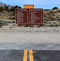
To the northeast up Corn Creek Road is Corn Creek Campsite and the Desert National Wildlife Refuge visitor center and parking lot.[5] Trails and dirt roads from the visitor center provide access to the Sheep Range and Las Vegas Range and Tule Springs Fossil Beds National Monument located further south closer to Las Vegas.
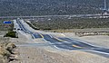
Corn Creek Road
Corn Creek Road is a roughly 4-mile paved road that provides access to the community via Landy Street and the DNWR visitor center and Corn Creek Campsite from U.S. Route 95. The road has a 45 mph speed limit. The western half is located in the Tule Springs Fossil Beds National Monument and the eastern half in the Desert National Wildlife Refuge.[6]
At the end of the road, Alamo Road and Mormon Well Road are accessible as well as Gass Peak Road which spurs off Mormon Well Road further into the wildlife refuge.
-
 Corn Creek Road looking east near U.S. Route 95
 -
 Corn Creek Road looking west near Landy Street
 -
 Corn Creek Road looking west near the visitor center
 -
 Eastern end of Corn Creek Road at its junction with Alamo Road


References
- ^ a b c "Corn Creek". Geographic Names Information System. United States Geological Survey, United States Department of the Interior.
- ^ Segall, Eli (2 July 2021). "Las Vegas homes are selling fast, even as sales totals fall". Las Vegas Review-Journal. Retrieved 21 November 2021.
- ^ "NOWData – NOAA Online Weather Data". National Oceanic and Atmospheric Administration. Retrieved December 1, 2022.
- ^ "Summary of Monthly Normals 1991–2020". National Oceanic and Atmospheric Administration. Retrieved December 1, 2022.
- ^ "Corn Creek". U.S. Fish & Wildlife Service. Retrieved 29 January 2021.
- ^ Boone, Jim (21 July 2014). "Corn Creek Road". Bird and Hike. Retrieved 29 January 2021.
Further reading
- Corn Creek and the History of Las Vegas Valley
- v
- t
- e
Municipalities and communities of Clark County, Nevada, United States
County seat: Las Vegas
communities
- Bard
- Bonelli's Ferry
- Borax
- Buster Falls
- Byron
- Callville
- Colorado City
- Crystal
- Dike
- Dry Lake
- El Dorado City
- Erie
- Gold Butte
- Louisville
- Lovell
- Lucky Jim Camp
- Nelson's Landing
- Owens
- Potosi
- Quartette
- Rioville
- Roach
- Saint Joseph
- Solar
- St. Thomas
- San Juan
- Simonsville
- Stone's Ferry
- Valley
- Wann
‡This populated place also has portions in an adjacent county or counties
- Nevada portal
- United States portal
| |
|---|---|
Carson City (capital) | |
| Topics |
|
| Society | |
| Regions | |
| Metro areas | |
| Counties | |
| Cities and communities |
|
| Former counties | |
 Nevada portal Nevada portal | |


