Eurydice Peninsula
Eurydice Peninsula (Bulgarian: полуостров Евридика, romanized: poluostrov Evridika, IPA: [poɫuˈɔstrof ɛvriˈdikɐ]) is the predominantly ice-covered 8 km wide peninsula projecting from Danco Coast, Antarctic Peninsula 7.4 km northwestwards into Charlotte Bay south of Recess Cove. It ends in Sepúlveda Point to the north and Meusnier Point to the west.
The feature is named after Eurydice, the mythical wife of the Thracian singer Orpheus.
Location
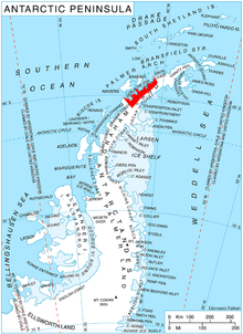
Eurydice Peninsula is centred at 64°33′50″S 61°31′40″W / 64.56389°S 61.52778°W / -64.56389; -61.52778. British mapping in 1978.
Maps
- British Antarctic Territory. Scale 1:200000 topographic map. DOS 610 Series, Sheet W 64 60. Directorate of Overseas Surveys, UK, 1978.
- Antarctic Digital Database (ADD). Scale 1:250000 topographic map of Antarctica. Scientific Committee on Antarctic Research (SCAR), 1993–2016.
References
- Eurydice Peninsula. SCAR Composite Antarctic Gazetteer.
- Bulgarian Antarctic Gazetteer. Antarctic Place-names Commission. (details in Bulgarian, basic data in English)
External links
- Eurydice Peninsula. Copernix satellite image
This article includes information from the Antarctic Place-names Commission of Bulgaria which is used with permission.
- v
- t
- e


