Financial District, Los Angeles
Neighborhood of Los Angeles in County of Los Angeles, California, United States
34°03′03″N 118°15′18″W / 34.05083°N 118.25500°W / 34.05083; -118.25500 United States
 California
 Los Angeles
The Financial District (Financial Core) is the central business district of Los Angeles along Olive, Grand, Hope, Flower and Figueroa streets from 4th Street to 8th Street. It is south of the Bunker Hill district, west of the Historic Core, north of South Park and east of the Harbor Freeway and Central City West.[1] Like Bunker Hill, the Financial District is home to corporate office skyscrapers, hotels and related services as well as banks, law firms, and real estate companies. However, unlike Bunker Hill which was razed and now consists of buildings constructed since the 1960s, it contains large buildings from the early 20th century, particularly along Seventh Street, once the city's upscale shopping street; the area also attracts visitors as the 7th and Flower area is at the center of the regional Metro rail system and is replete with restaurants, bars, and shopping at two urban malls.
History
What is now the Financial District was originally agricultural land, then a residential area of single family homes, then around 1900 started attracting businesses as Victorian-era Downtown L.A. expanded south along Broadway past 3rd Street and "around the corner", west along Seventh Street. Around 1915, 7th Street between Broadway (on which corner stood Bullock's) and Figueroa Street, became downtown's upscale shopping district. This began with J. W. Robinson's deciding to build their flagship store in 1915 on Seventh far to the west of the existing Broadway shopping district, between Hope and Grand streets. The Ville de Paris and Coulter's as well as numerous specialty shops came and rounded out the district. The area lost its exclusivity when the upscale downtown stores opened branches in Hollywood, Mid-Wilshire, Westwood and Pasadena in the late 1920s through the 1940s, notably the establishment of Bullock's upscale landmark branch Bullocks Wilshire in Mid-Wilshire in 1929.[2]
Thirteen large office buildings opened between 1920 and 1928. By 1929, every plot on 7th between Figueroa and Los Angeles Streets had been developed.[2]
The area remained an important, if not the most exclusive, center of retail and office space throughout the 1950s, but started a slow decline throughout the 1980s due to suburbanization. It was also the concentration of Downtown financial activity on Bunker Hill, a few blocks north. The flagship department stores like Bullock's (1983), Barker Brothers (1984) and Robinson's (1993) had closed and only the Broadway/Macy's at The Bloc, previously named Broadway Plaza remained. However, in 1986, the Seventh Market Place mall, now FIGat7th, opened, bringing a smaller retail cluster back to Seventh such as the 7th Street/Metro Center station opening in 1991.
The Financial District was created by the Los Angeles Community Redevelopment Agency to provide an alternative to the old Spring Street Financial District, which fell into decline in the second half of the 20th century.
Demand for apartments in downtown Los Angeles surged in 2010 and the years following. In 2015, thousands of apartments were under construction or proposed for the area around 8th Street.[3]
Historic photos
-
 1916 view towards the east on 6th St. from near the Southland Hotel at SW corner of 6th and Flower. Baker-Detweiler Building is on south side of Pershing Square between Olive and Hill.
 -
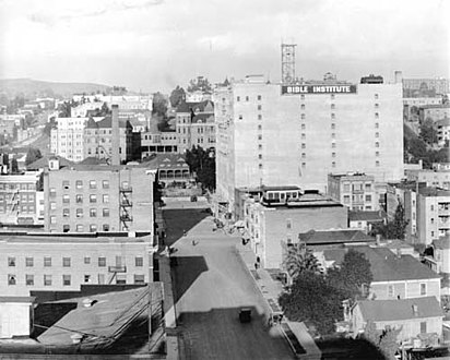 Looking north on Hope Street past Bible Institute of Los Angeles (now Biola University), 1912
 -
 7th Street looking west from Main Street, 1907, not yet a commercial district
 -
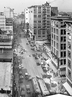 7th Street looking west from Broadway, 1917. Bullocks far right; B. H. Dyas sporting goods store, right; Ville de Paris, at left.
 -
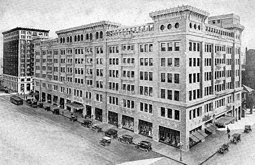 J. W. Robinson's flagship store on Seventh Street at launch, 1915. Robinson's locating on 7th marked the beginning of the street as the upmarket downtown shopping district
 -
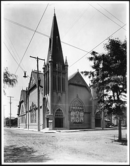
 Simpson Methodist Episcopal Church, Hope between 7th/8th, c.1890-1905 (CHS-1314).jpg
 -
 First Congregational Church on Hope Street between 8th/9th, c.1905
 -
 First Christian Church, Hope and 11th, c.1910


Transportation
The Los Angeles County Metropolitan Transportation Authority (Metro Rail & Metro Busway), and LADOT (DASH & Commuter Express) provide heavy rail (subway), light rail, and local bus services throughout the Financial Core and to the Greater Los Angeles Area.
7th St/Metro Center station provides primary access to Metro B Line, D Line, A Line, and E Line.
Landmarks
-
 Westin Bonaventure Hotel & Suites, SE corner 4th/Figueroa
 -
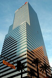
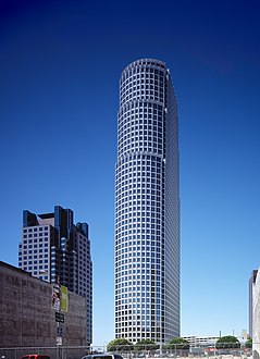
 City National Plaza, 5th to 6th, Flower to Figueroa
 -
 FourFortyFour South Flower, NE corner of 5th/Flower
 -
-
 Millennium Biltmore Hotel, west side of Pershing Square (S side of 5th from Olive to Grand)
 -
 Figueroa at Wilshire building, SW corner 6th/Figueroa
 -
 View east along 6th incl. Southland Hotel at SW corner 6th/Flower c.1916. Demolished 1971. now site of Pacific Financial Center.
 -
 Superior Oil Company Building, NE corner 6th/Flower
 -
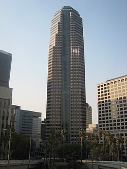
 Aon Center, W side of Hope from 6th to Wilshire
 -
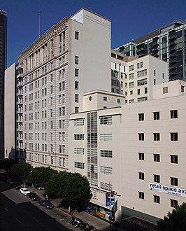
 PacMutual building, north side of 6th from Grand to Olive
 -
 Ernst & Young Plaza, SW corner 7th/Figueroa
 -
 777 Tower at NW corner 8th/Figueroa
 -
 Fine Arts Building, N side of 7th, W of Flower
 -
 MCI Center (orig. Broadway Plaza), SE corner 7th/Flower
 -
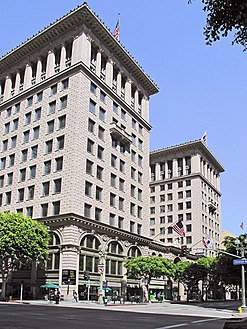
 Brockman Building, SE corner 7th and Grand
 -
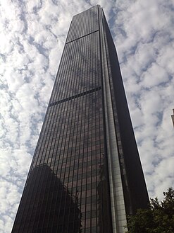
 Wilshire Grand Center a.k.a. Korean Air Tower, SW corner Wilshire/Figueroa
 -
 Southern California Gas Company Complex, SE corner 8th/Flower


Landmarks in the district include, from west to east and north to south:
Fifth Street:
- Westin Bonaventure Hotel & Suites, block bounded by 4th, 5th, Figueroa, Flower; 404 S. Figueroa, opened 1976, John C. Portman Jr., architect.
- FourFortyFour South Flower, formerly Citigroup Center, 48 floors, 191 m (627 ft.), NE corner of 5th and Flower, 444 S. Flower, opened 1981, Albert C. Martin & Associates, architects
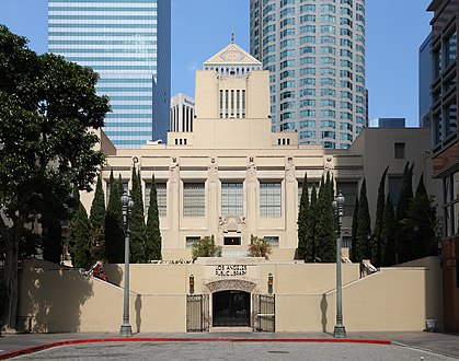
- Richard J. Riordan Central Library (Los Angeles Public Library), south side of 5th at Hope, 630 W. 5th St., opened 1926, Bertram Grosvenor Goodhue, architect.
- Millennium Biltmore Hotel, on south side of 5th from Olive to Grand, facing Pershing Square, opened 1923
- Pershing Square, between 5th, 6th, Hill and Olive
Sixth Street:
- Figueroa at Wilshire, originally Sanwa Bank Plaza, 53 stories, 218.5m, 717 ft., SW corner 6th and Figueroa, 601 S. Figueroa, opened 1990, Albert C. Martin & Associates, architects.
- SW corner of 6th/Flower: Pacific Financial Center, 18 stories, 1973, architect William Pereira and Assoc.[4] Site of Southland Hotel, opened 1910, demolished 1971.[5]
- Superior Oil Company Building (The Standard Hotel, Downtown Los Angeles), NE corner 6th and Flower, 550 S. Flower, opened 1956, Claud Beelman and William Simpson, architects.
- 611 Place, NW corner 6th and Grand.
- PacMutual Building, (originally the Pacific Mutual Building), northwest corner of 6th and Olive, completed in stages in 1908, 1921, 1926, 1936; architects Dodd & Richards and Parkinson & Bergstrom, Beaux-Arts and Moderne architecture.
- Aon Center, 67 floors, height 261.52 m (858.0 ft), W side of Hope between 6th and Wilshire, 707 Wilshire Bl., opened 1974, Charles Luckman, architect.
- James Oviatt Building, former home of Alexander & Oviatt men's clothing store, 6th and Olive
Seventh Street:
- Wilshire Grand Center a.k.a. Korean Air Tower, 73 floors, 335 m (1,100 ft.), occupying the block from Wilshire to 7th and from Figueroa to Francisco, 900 Wilshire Bl., opened 2017, AC Martin Partners, architects. Site of the 1952 Hotel Statler, later the Los Angeles Hilton.
- Ernst & Young Plaza, 41 floors, 163m, 534 ft., SW corner of 7th and Figueroa, 725 S. Figueroa, opened 1985
- Fine Arts Building, near NW corner 7th and Flower, 811 W. 7th, opened 1927, Albert Raymond Walker and Percy Augustus Eisen, architects.
- MCI Center (originally Broadway Plaza), 33 floors, 126 m (414 ft.), SE corner of 7th and Flower, 700 S. Flower, opened 1973, Luckman Partership, architects. The Bloc shopping center is located in the complex.
- Brockman Building, SE corner 7th and Grand, 520–530 W. 7th, opened 1912, Barnett, Haynes & Barnett, architects.
- City National Plaza, originally ARCO Plaza, twin towers, occupying the entire block from 5th to 6th and from Flower to Figueroa, 505–555 S. Flower, opened 1971, Albert C. Martin & Associates, architects
- Los Angeles Athletic Club, NE corner 7th and Olive, 431 W 7th, opened 1912, by John Parkinson and George Bergstrom, architects.
Eighth Street:
- 777 Tower (originally Citicorp Plaza), 52 stories, NW corner 8th and Figueroa, 777 S. Figueroa, opened 1991; and the adjacent FIGat7th (originally Seventh Market Place) shopping center, opened in 1986.
- Southern California Gas Company Complex, SE corner 8th and Flower, 800–830 S. Flower, first part opened 1925, Parkinson & Parkinson et al., architects. Six-story extension at 820 S. Flower: opened 1942, Robert V. Derrah architect.
Other:
Map of buildings and historic sites
Landmarks are shown on the following street grid of the Financial District of Downtown Los Angeles.
Abbreviations and notes
- Abbreviations: DS=Department Store. res.=residential building
- Architectural styles: AD=Art Deco, BA=Beaux-Arts, BR=Baroque Revival, CR=Classical Revival, IRR=Italian Renaissance Revival, It=Italianate, Rom=Romanesque, RR=Renaissance Revival
- Architects: C&B=Curlett & Beelman, JP=John Parkison, P&B=Parkinson & Bergstrom, RBY=Robert Brown Young
- Italics indicate the building's current name or main tenant.
- Non-italics indicate a historic name or tenant of an existing building.
- *An asterisk indicates a demolished building.
For the area to the east, see Historic Core
| F I G U E R O A | Westin Bonaventure Hotel & Suites | F L O W E R | FourFortyFour South Flower | U.S. Bank Tower OUE Skyspace | CalEdison DTLA (a.k.a. One Bunker Hill, 1931) | G R A N D | Gas Company Tower | O L I V E | Park Fifth Towers (2019, res.) Site of Hazard's Pavilion, Temple/Clune's/Philharmonic Auditorium | |||||
| FIFTH STREET | ||||||||||||||
| City National Plaza (ex-ARCO Center) | Central Library | Millennium Biltmore Hotel | Pershing Square | |||||||||||
| Superior Oil Company Building | H O P E | AT&T Center (Site of Savoy Hotel NW 6th/Grand) | PacMutual | |||||||||||
| SIXTH STREET | ||||||||||||||
| Figueroa at Wilshire | Aon Center | Lincoln Savings Bldg. (1955) now Library Court (res) | Milano Lofts (1925) | Douglas Oil Bldg. #3 | Heron Bldg. (1921, Dodd) | |||||||||
| WILSHIRE BL. | ||||||||||||||
| Wilshire Grand Center a.k.a. Korean Air Tower | Figueroa (Home Savingss) Tower | Fine Arts Building | Roosevelt Building, 7th Street/Metro Center subway | Union Oil Bldg. (1923) | Quinby Bldg. (1926), Bronson Bldg. (The Collection) (1913) | Bank of Italy (1922), Brock and Co. Bldg. (1922) | Los Angeles Athletic Club (1912) | |||||||
| SEVENTH STREET | ||||||||||||||
| Ernst & Young Plaza, FIGat7th | Barker Bros. DS Bldg. | MCI Center (orig. Broadway Plaza), 7th Street/Metro Center subway | J.W. Robinson's DS Bldg. | Brockman Building (1912, once home to Haggarty's DS) | Coulter's DS (later Myer Siegel, Dohrmann's, now The Mandel) | Ville de Paris DS, now L.A. Jewelry Mart (1917) | ||||||||
| 777 Tower | ||||||||||||||
| EIGHTH STREET | ||||||||||||||
| Southern California Gas Company Complex | 8th+Hope | |||||||||||||
References
- ^ Map, Downtown Center Business Improvement District
- ^ a b Strolling along Seventh Street (PDF). Los Angeles Conservancy. 2010.
- ^ Vincent, Roger (February 19, 2015) "Whole Foods to anchor posh apartment complex in downtown L.A." Los Angeles Times
- ^ "Pacific Financial Center", Emporis[dead link]
- ^ "$12 Million Building to Replace Dowdy Hotel on 6th Street". The Los Angeles Times. 1971-03-02. p. 25. Retrieved 2020-11-11.
External links
 Los Angeles portal

 Media related to Financial District, Los Angeles at Wikimedia Commons
- v
- t
- e
neighborhoods
- Arts District
- Bunker Hill
- Chinatown
- Civic Center
- Fashion District
- Financial District
- Flower District
- Gallery Row
- Historic Core
- Broadway Theater District
- Old Bank District
- Spring Street Financial District
- Victorian Downtown
- Jewelry District
- Los Angeles Plaza
- Little Tokyo
- Skid Row
- South Park
- Toy District
- Wholesale District

Points of
Interest
| Museums | |
|---|---|
| Parks |
|
| Plazas |
|
| Restaurants |
|
| Schools | |
| Shopping | |
| Other |
| Freeways | |||||||
|---|---|---|---|---|---|---|---|
| Metro |
| ||||||
| Streets |
| ||||||
| Union Station | |||||||
| Other |


