Gama | |
|---|---|
| Região Administrativa de Gama Administrative Region of Gama | |
Clockwise from top: Skyline; Bezerrão; Capela São Francisco; Forum; and Balão do Periquito | |
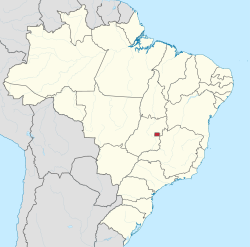
 Localization of Gama in Federal District | |
| Coordinates: 16°01′10″S 48°04′01″W / 16.01944°S 48.06694°W | |
| Country | |
| Region | Central-West |
| State | |
| Founded | October 12, 1960 |
| Government | |
| • Regional administrator | Maria Antônia Rodrigues Magalhães[1] |
| Area | |
• Total | 27.634 km2 (10.670 sq mi) |
| Elevation | 1,000 m (3,000 ft) |
| Population (2010)[2] | |
• Total | 127,121 |
| • Density | 4,600/km2 (12,000/sq mi) |
| Demonym | Gamense |
| Time zone | UTC−3 (BRT) |
| Postal Code (CEP) | 72400-000 |
| Area code | +55 61 |
| Website | www.gama.df.gov.br |
Gama (Portuguese pronunciation: [ˈɡɐ.ma]) is an administrative region in the Federal District in Brazil. It is bordered by Recanto das Emas to the north, Riacho Fundo II and Park Way to the northeast, and Santa Maria to the east.
History
[edit]In late 1746, Bandeirante Antônio Bueno de Avezedo left Paracatu, Minas Gerais, leading a group of friends and numerous slaves.[3] The group traveled northwestward, reaching the banks of a river that Bueno named São Bartolomeu, in honor of the saint of the day.[4] There he built farms and some ranches. In December of that year, Bueno continued westward, settling in the place he named Santa Luzia. Santa Luzia village eventually grew into today's Luziânia, Goiás and was officially renamed such in 1943.[3]
The settlement's founding was linked to gold mining. Mining was so intense that the newly founded settlement soon had a population of 10,000, including slaves.[3] The first Mass in Santa Luzia was officiated by Father da Gama Mendonça on March 25, 1747, with over 6,000 people in attendance.[3] Due to the settlement's rapid growth, it was designated a Judiciary in 1749 and became a collective parish by decree in 1756.[3] Two years later, in 1758, Santa Luzia was elevated to an Ecclesiastical District, with Father Domingos Ramos appointed as its Vicar.[3]
That same year, in April 1758, a major engineering project began to better exploit the "Cruzeiro" mines.[3] Thousands of slaves worked uninterrupted for two years to construct the Rêgo Saia Velha, a 42-kilometer canal.[3] However, its inauguration sparked a large riot in the village, leading the local judge to order the arrest of several prominent figures, including the project's foreman.[3]
When the capital of Brazil was transferred upcountry, the farmlands were dispossessed by the government of Goiás, between 1956 and 1958, under the responsibility of a Commission organized to transfer the capital of Brazil, presided over by Altamiro de Moura Pacheco.
The headquarters of a farm called "Gama" was close to the Catetinho (first official residence of President Juscelino Kubitschek); nevertheless the city was settled 8 kilometers (5.0 mi) away from this reference point. President Juscelino Kubitschek visited Gama on October 2, 1956, on his first visit to the region where the new capital would be built. The city was initially created to shelter people resident in invasions or provisional shelters, or those that would work on Brasília’s construction.
Architect Paulo Hungria had, by May 1960, developed the blueprint of the city, which would have the form of a beehive, dividing it into five sectors: North, South, East, West and Centre. The Centre Sector (for trade activities) was not so detailed due to future needs. Notwithstanding this, engineer José Maciel de Paiva, by order of mayor Israel Pinheiro (former president of Novacap), was charged with setting up a pioneer center and promoting the first transferences from September 1960 on. He was assisted by an engineer, José Carlos Godoy, by an inspector, Agnelo Dias Correia, and by a master-builder, Joaquim Santana and others. The initial settlement was carried out by removing 30 families resident in the "Barragem do Paranoá". Gama was founded on October 12, 1960, receiving the status of administrative region, according to Law 4545, of December 10, 1964.
Later the city received many of the former residents of "Vila Amaury" and "Vila Planalto". In 1970, the inhabitants settled in the Industry Sector of Taguatinga were transferred.
Name Origin
[edit]While the definitive origin of the name "Gama" is unconfirmed, its geographical source is certain: it traces back to the Gama Plateau, the location of the Gama stream's headwaters. The most plausible theory suggests that these landmarks were named in honor of Father Luiz da Gama Mendonça.[5]
Notable people
[edit]- Kaká, footballer
Sport
[edit]Gama is home to the Bezerrão stadium, and the local professional association football team is SE Gama.
See also
[edit]References
[edit]- ^ "Perfil da administradora" (in Portuguese). Administração Regional de Gama, DF. Retrieved January 1, 2015.
- ^ "Pesquisa Distrital por Amostra de Domicílios – 2010/2011" (PDF) (in Portuguese). Codeplan. Retrieved August 20, 2012.[permanent dead link]
- ^ a b c d e f g h i "História de Luziânia". Prefeitura Municipal de Luziânia (in Portuguese). Retrieved August 21, 2025. "Luziânia: Histórico" (in Portuguese). Instituto Brasileiro de Geografia e Estatística (IBGE). Archived from the original on September 20, 2021. Retrieved August 21, 2025.
- ^ "Luziânia". Associação Goiana de Municípios (in Portuguese). Retrieved August 21, 2025.
- ^ "Apresentação". Administração Regional do Gama (in Portuguese). Archived from the original on March 26, 2025. Retrieved August 21, 2025.


