Giraud Peak
Mountain in the American state of California


Giraud Peak
Location in California
Show map of California
Giraud Peak
Giraud Peak (the United States)
Show map of the United StatesPalisades[1]
Giraud Peak is a 12,608-foot-elevation (3,843-meter) mountain summit located west of the crest of the Sierra Nevada mountain range, in Fresno County of northern California, United States.[3] It is situated in the Palisades area of northern Kings Canyon National Park, 3.0 miles (4.8 km) southwest of North Palisade, and 1.5 miles (2.4 km) southwest of Columbine Peak, the nearest higher neighbor.[1] Giraud Peak ranks as the 258th-highest summit in California.[2] Topographic relief is significant as the west aspect rises 4,400 feet (1,300 meters) above LeConte Canyon in less than two miles. On the direct opposite side of the canyon The Citadel stands guard. The first ascent of the summit was made September 1, 1925, by Norman Clyde via the east arête.[4]
Etymology
This mountain's name has been officially adopted by the United States Board on Geographic Names.[3] It was probably named for Pierre "Little Pete" Giraud (1874–1907), a shepherd of Inyo County who was made famous in Mary Austin's 1906 book, The Flock.[5][6] Pierre and his younger brother, Alfred, were French immigrants who arrived in the Owens Valley, where they grazed sheep for many years at the head of the South and Middle Forks of Kings River.[7]
Climate
Giraud Peak is located in an alpine climate zone.[8] Most weather fronts originating in the Pacific Ocean travel east toward the Sierra Nevada mountains. As fronts approach, they are forced upward by the peaks, causing them to drop their moisture in the form of rain or snowfall onto the range (orographic lift). Precipitation runoff from this mountain drains into tributaries of the Middle Fork Kings River.
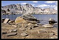
Gallery
-
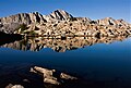 from Dusy Basin
 -
 from Dusy Basin
 -
 from Bishop Pass. (The top of Devils Crags visible to the right)


See also
 Mountains portal

References
- ^ a b c d "Giraud Peak, California". Peakbagger.com. Retrieved 2021-06-06.
- ^ a b c d "Giraud Peak - 12,608' CA". listsofjohn.com. Retrieved 2021-06-06.
- ^ a b c "Giraud Peak". Geographic Names Information System. United States Geological Survey, United States Department of the Interior. Retrieved 2021-06-06.
- ^ Hervey Voge and David R. Brower, A Climber's Guide to the High Sierra (1954)
- ^ Francis P. Farquhar, Place Names of the High Sierra (1926)
- ^ Peter Browning, Place Names of the Sierra Nevada: From Abbot to Zumwalt, Wilderness Press, 1986, ISBN 9780899970479, page 128.
- ^ Gena Philibert-Ortega , 2007, Cemeteries of the Eastern Sierra, Arcadia Publishing, ISBN 9780738547862, page 43.
- ^ "Climate of the Sierra Nevada". Encyclopædia Britannica.
External links
- Weather forecast: Giraud Peak
- Pierre Joseph Giraud photo (Page 26, with bear)
Places adjacent to Giraud Peak | ||||||||||||||||
|---|---|---|---|---|---|---|---|---|---|---|---|---|---|---|---|---|
| ||||||||||||||||


