Golani Interchange
Highway interchange in Israel
You can help expand this article with text translated from the corresponding article in Hebrew. Click [show] for important translation instructions.
- Machine translation, like DeepL or Google Translate, is a useful starting point for translations, but translators must revise errors as necessary and confirm that the translation is accurate, rather than simply copy-pasting machine-translated text into the English Wikipedia.
- Do not translate text that appears unreliable or low-quality. If possible, verify the text with references provided in the foreign-language article.
- You must provide copyright attribution in the edit summary accompanying your translation by providing an interlanguage link to the source of your translation. A model attribution edit summary is
Content in this edit is translated from the existing Hebrew Wikipedia article at [[:he:מחלף גולני]]; see its history for attribution. - You may also add the template
{{Translated|he|מחלף גולני}}to the talk page. - For more guidance, see Wikipedia:Translation.
junction
 Highway 65
 Highway 77
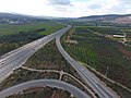
Golani Interchange (Hebrew: מחלף גולני), known as Maskana Junction in Arabic,[1] is a key road interchange in the Lower Galilee region of northern Israel, located east of Haifa and west of Tiberias, at the intersection of highways 65 and 77.[2] The Golani Brigade Museum commemorating the Golani Brigade is situated there.[3]
History
The previous at-grade intersection at Golani Junction experienced frequent traffic congestion on weekends and holidays when many Israelis travelled to the north of the country on vacation. Construction began in 2012 on an interchange to replace the former junction at a cost of NIS 300 million.[4][5] The interchange opened for traffic in August 2013.[4]
Gallery
-
 Golani interchange and the memorial site of the Golani brigade, January 2019
 -
 Golani interchange, January 2019
 -
 Golani interchange heading north, January 2019
 -
 Golani interchange heading west, January 2019
 -
 Golani interchange, January 2019
 -
 Golani Interchange, view from north Route 65
 -
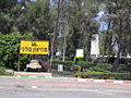 Memorial and Golani Museum, Golani Interchange


References
- ^ Cohen, Hillel (2010). Good Arabs: the Israeli security agencies and the Israeli Arabs, 1948-1967. University of California Press. p. 46. ISBN 978-0-520-25767-2.
- ^ Jacobs, Daniel; Shirley Eber; Francesca Silvani (1998). Israel and the Palestinian territories: the rough guide. Rough Guides. p. 86. ISBN 978-1-85828-248-0.
- ^ Mansvelt, Juliana (2005). Geographies of consumption. SAGE. p. 136. ISBN 978-0-7619-7430-7.
- ^ a b Berner, Danny (August 20, 2013). "Golani Interchange Opened for Traffic". Israel HaYom (in Hebrew). Retrieved August 27, 2013.
- ^ "Golani Junction Becoming Interchange". Jerusalem Post. 5 April 2012.
- v
- t
- e
 | This article about transport in Israel is a stub. You can help Wikipedia by expanding it. |
- v
- t
- e


