Haihaiyavanshi Kingdom
Kalachuris of Rayapura | |||||||||
|---|---|---|---|---|---|---|---|---|---|
| 14th century–1758 | |||||||||
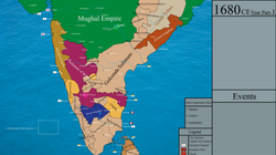 The Haihaiyavanshi Kingdom shown at the end of the 17th century, split into two branches at Ratanpur and Raipur | |||||||||
| Capital | Raipur (Rayapura) | ||||||||
| Religion | Hinduism | ||||||||
| Government | monarchy | ||||||||
| History | |||||||||
• Separation from the Kalachuris of Ratnapura | 14th century | ||||||||
• Maratha inavsion of 1740 and annexation by Bimbaji Bhonsle in 1758 | 1758 | ||||||||
| |||||||||
| Today part of | India | ||||||||
The Haihaiyavansi Kingdom, ruled by the Kalachuris of Raipur was a kingdom which consisted of the central part of the present-day state of Chhattisgarh located in India.
In 1740, the Maratha general of Nagpur, Bhaskar Pant conquered the kingdom for Raghoji I Bhonsle.[1] The Raipur branch of the kingdom survived until 1753, also being annexed by the Marathas of Nagpur.[2]
The last ruler was Mohan Singh, who ruled under the suzerainty of Raghoji Bhonsle of Nagpur and died in 1758.[3]
History
The Kalachuris of Raipur branched off from the Kalachuris of Ratnapura in the 14th century; the Ratnapura branch was, in turn, an offshoot of the Kalachuris of Tripuri.[4]
The Raipur kingdom originated as the eastern province of the tenth-century Tripuri Kalachuri or Chedi kingdom, which was centered in the upper Narmada River valley.[5] The kingdom was located east of the main routes between northern and southern India, and thus was unaffected by the Muslim invasions of the 13th-16th centuries.[5][6][page needed] The kingdom enjoyed 700 years of peaceful existence due to its borders being protected by precipitous mountain ranges on almost all sides.[5][better source needed][7]
In the second half of the 14th century, on the accession of Suradeva, the 20th king, the Ratnapura kingdom was divided between him at Ratanpur (Ratnapura) and his younger brother Brahmadeva founded a younger branch at Raipur to the south.[8][unreliable source?][9][5] At the end of the 16th century, the Haihaiyavanshi kings recognized the suzerainty of the Mughal Empire.
It has been conjectured that the name Mahakosal, the greater Kosala, was made common for Dakshin Kosal or Chhattisgarh by the Chedi - Haihaiyavanshi rulers of this region to make their kingdom sound more dignified and their sovereignty seem more pronounced.[10][unreliable source?][11] The town of Amarkantak is said to have been built by the Haihayavanshis.[6]: 263 [unreliable source?]
Maratha invasion
The Bhonsle Maratha armies passed through Chhattisgarh on their way to invade the Odia kingdoms in eastern India. Bhaskar Pant invaded the Haihaiyavanshi Kingdom at the close of 1740. The branch Haihaiyavanshi ruler of Raipur, Amar Singh, did not oppose him. However, the main Haihaiyavanshi ruler of Ratanpur, Raghunath Singh offered resistance by shutting himself in his fort.[12][unreliable source?]
A fine of one lakh rupees was imposed on Ratanpur, all the wealth that remained in the treasury was confiscated and the country was pillaged thoroughly. However, Raghunath Singh was not harmed and was allowed to rule at Ratanpur under the suzerainty of the Marathas. Having crushed the Haihaiyavanshi king, the nominal overlord of the many petty chieftains and surrounding states, The Marathas demanded that the petty rulers formerly under Haihaiyavanshi rule submit to them, with which they complied.[12]
Raigarh fell to the Bhonsles in 1741, and by 1742 Maratha control over the kingdom was firmly established.[9]
Maratha suzerainty
After the death of Raghunath Singh in 1745, Mohan Singh a member of the Haihaiyavanshi Raipur branch, was placed on the throne by Raghoji I Bhonsle. He was loyal to the Bhonsle Nagpur Kingdom and paid regular tribute to the Bhonsle treasury. However, in 1758, Bimbaji Bhonsle was sent against him to assume direct control of Chhattisgarh. Mohan Singh started amassing his forces near Raipur, but died shortly after and thus, Bimbaji Bhonsle assumed rule of the region with ease.[13][14][unreliable source?][15][unreliable source?]
Administration
According to a tradition, popularized by Cecil Upton Wills (1919), the principalities Raipur and Ratanpur were "sub-kingdoms", and each had 18 forts; the name "Chhattisgarh" derives from these 36 (Chhattis) forts (garh). However, experts disagree with this theory for several reasons: the name Chhattisgarh does not appear in early records, no historical records identify the 36 forts, and early records list 48 forts in the area.[16]
According to Willis, the term garh referred to a district, which was under the charge of the feudal lords (thakurs or diwans), who owed allegiance to the king. The garh was also known as chaurasi (eighty-four) because it was meant to be made up of 84 villages. The garhs were in turn made up of smaller units called taluks. The taluk, which was supposed to contain 12 villages and was also known as bahron (twelve) was held by a dao or barhainya whose authority in the unit closely resembled that of the diwan within the taluk. The village was held by a gaonthia or headman.[17]
Several parts of Chhattisgarh country were held by feudatory chiefs who ruled under the suzerainty of the Haihaiyavanshis. Some were Kanker State, Sarangarh State and Sakti State.[18][non-primary source needed][19][unreliable source?][20][unreliable source?]
See also
References
- ^ Mellor, John Williams; Weaver, Thomas F.; Lele, Uma J. (1968). Developing Rural India: Plan and Practice. Cornell University Press. ISBN 978-0-8014-0296-8.
- ^ India, Archaeological Survey of (1884). Reports. Office of the Superintendent of Government Printing.
- ^ Mishra, P. L. (1969). "Mohansingh (The Last Kalachuri King)". Proceedings of the Indian History Congress. 31: 207–213. JSTOR 44138363.
- ^ Om Prakash Misra (2003). Archaeological Excavations in Central India: Madhya Pradesh and Chhattisgarh. Mittal. pp. 13–14. ISBN 978-81-7099-874-7.
- ^ a b c d McEldowney, Philip Fredric (August 1980). "Administrative and Social Regions of Middle India, 1500-1920". Colonial Administration and Social Developments in Middle India: The Central Provinces, 1861-1921. University of Virginia. pp. 22–24.
- ^ a b Mehta, Behram H. (1984). Gonds of the Central Indian Highlands. Concept Publishing Company.
- ^ The Deccan Geographer. Deccan Geographical Society. 1984.
- ^ Hunter, William Wilson (1881). The Imperial Gazzetter of India: Vol 7: Naaf to Rangmagiri. Trübner. p. 485-487.
- ^ a b Dube, Saurabh (19 March 1998). Untouchable Pasts: Religion, Identity, and Power Among a Central Indian Community, 1780-1950. SUNY Press. ISBN 978-0-7914-3688-2.
- ^ Pradesh (India), Madhya (1973). Madhya Pradesh District Gazetteers: Dewas. Government Central Press.
- ^ Pradesh (India), Madhya (1965). Madhya Pradesh: Durg. Government Central Press.
- ^ a b Grant, Charles (1870). The Gazetteer of the Central Provinces of India. Education Society's Press.
- ^ Mishra, P. L. (1969). "Mohansingh (The Last Kalachuri King)". Proceedings of the Indian History Congress. 31: 207–213. JSTOR 44138363.
- ^ Pradesh (India), Madhya (1978). Madhya Pradesh District Gazetteers: West Nimar. Government Central Press.
- ^ Nelson, Sir Arthur Edward (1909). Raipur District: Volume A, Descriptive. Printed at the British India Press, Byculla.
- ^ Helen Macdonald (2020). Witchcraft Accusations from Central India: The Fragmented Urn. Taylor & Francis. p. 44. ISBN 9781000225716.
- ^ Dube, Saurabh (1998). Untouchable Pasts: Religion, Identity, and Power Among a Central Indian Community, 1780-1950. SUNY Press. p. 27. ISBN 978-0-7914-3688-2.
- ^ Ratanpur Akhyan by Pandit Shiv Dutt Shastri
- ^ Central Provinces district gazetteers, Vol 10. Allahabad: Pioneer Press. 1906. p. 8-9.
- ^ Hunter, William Wilson (2016). Imperial Gazetteer of India, Volume 14. Creative Media Partners. ISBN 9781313266239.


