Hameln-Pyrmont
District in Lower Saxony, Germany
You can help expand this article with text translated from the corresponding article in German. (July 2015) Click [show] for important translation instructions.
- View a machine-translated version of the German article.
- Machine translation, like DeepL or Google Translate, is a useful starting point for translations, but translators must revise errors as necessary and confirm that the translation is accurate, rather than simply copy-pasting machine-translated text into the English Wikipedia.
- Consider adding a topic to this template: there are already 9,120 articles in the main category, and specifying
|topic=will aid in categorization. - Do not translate text that appears unreliable or low-quality. If possible, verify the text with references provided in the foreign-language article.
- You must provide copyright attribution in the edit summary accompanying your translation by providing an interlanguage link to the source of your translation. A model attribution edit summary is
Content in this edit is translated from the existing German Wikipedia article at [[:de:Landkreis Hameln-Pyrmont]]; see its history for attribution. - You may also add the template
{{Translated|de|Landkreis Hameln-Pyrmont}}to the talk page. - For more guidance, see Wikipedia:Translation.
District in Lower Saxony, Germany

Flag
Coat of arms

(31 December 2022)[1]
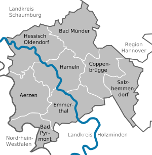
Hameln-Pyrmont is a district (Landkreis) in Lower Saxony, Germany. It is bounded by (from the north and clockwise) the districts of Schaumburg, Hanover, Hildesheim and Holzminden, and by the state of North Rhine-Westphalia (district of Lippe).
History
A district called Hameln was established in 1885 within the Prussian Province of Hanover. At that time the city of Pyrmont was part of the Principality of Waldeck-Pyrmont. In 1921 Pyrmont decided in a plebiscite to leave Waldeck-Pyrmont and to join Prussia. The Prussian administration assigned the city to the district of Hameln, which was renamed to Hameln-Pyrmont.
In 1923 Hameln became a district-free city and was not part of the district until 1973, when it was reincorporated. Further enlargements of the district's territory took place in 1974 and 1977, when the cities of Bad Münder and Hessisch Oldendorf joined the district.
Geography
The district is located in the northern part of the Weserbergland mountains. The Weser River enters the district in the south, runs through Hameln and leaves in the northwest towards Rinteln.
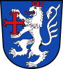
Coat of arms
The lion is the heraldic animal of the County of Everstein, which ruled over the territory until 1429. The red cross in the lion's hands was the symbol of Pyrmont.
Towns and municipalities
| Cities | Municipalities |
|---|---|
See also
References
- ^ "LSN-Online Regionaldatenbank, Tabelle A100001G: Fortschreibung des Bevölkerungsstandes, Stand 31. Dezember 2022" (in German). Landesamt für Statistik Niedersachsen.
External links
![]() Media related to Landkreis Hameln-Pyrmont at Wikimedia Commons
Media related to Landkreis Hameln-Pyrmont at Wikimedia Commons
- Official website of Hameln-Pyrmont (German)
- Official website of Salzhemmendorf (German)
- bed and rich breakfast at Salzhemmendorf, district Lauenstein (English)
- v
- t
- e
 Urban and rural districts in the state of Lower Saxony in Germany
- Ammerland
- Aurich
- Bentheim
- Celle
- Cloppenburg
- Cuxhaven
- Diepholz
- Emsland
- Friesland
- Gifhorn
- Goslar
- Göttingen
- Hameln-Pyrmont
- Harburg
- Heidekreis
- Helmstedt
- Hildesheim
- Holzminden
- Leer
- Lüchow-Dannenberg
- Lüneburg
- Nienburg
- Northeim
- Oldenburg
- Osnabrück
- Osterholz
- Peine
- Rotenburg
- Schaumburg
- Stade
- Uelzen
- Vechta
- Verden
- Wesermarsch
- Wittmund
- Wolfenbüttel
Districts of German states (Full list)
- Baden-Württemberg
- Bavaria
- Brandenburg
- Bremen
- Hesse
- Lower Saxony
- Mecklenburg-Vorpommern
- North Rhine-Westphalia
- Rhineland-Palatinate
- Saarland
- Saxony
- Saxony-Anhalt
- Schleswig-Holstein
- Thuringia
52°05′N 9°20′E / 52.08°N 9.33°E / 52.08; 9.33
Authority control databases | |
|---|---|
| International |
|
| National |
|


