Heider Umland
Amt in Germany

Flag
Coat of arms
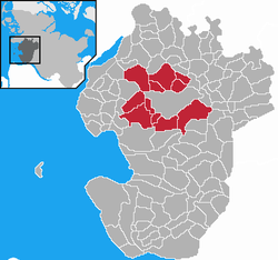
Map of Dithmarschen highlighting Heider Umland
Kirchspielslandgemeinde Heider Umland is an Amt ("collective municipality") in the district of Dithmarschen, in Schleswig-Holstein, Germany. It is situated around Heide, which is the seat of the Amt, but not part of it. It was formed on 1 January 2008 from the former Ämter Kirchspielslandgemeinde Heide-Land and Kirchspielslandgemeinde Weddingstedt and the municipality Norderwöhrden.
The Amt Kirchspielslandgemeinde Heider Umland consists of the following municipalities (with population in 2005):
- Hemmingstedt (2.989)
- Lieth (396)
- Lohe-Rickelshof (1.942)
- Neuenkirchen (1.044)
- Norderwöhrden (287)
- Nordhastedt (2.753)
- Ostrohe (963)
- Stelle-Wittenwurth (486)
- Weddingstedt (2.321)
- Wesseln (1.352)
- Wöhrden (1.334)
References
- v
- t
- e


The Ämter are listed per district (Kreis)
- Burg-Sankt Michaelisdonn
- Büsum-Wesselburen
- Eider
- Heider Umland
- Marne-Nordsee
- Mitteldithmarschen
- Berkenthin
- Breitenfelde
- Büchen
- Hohe Elbgeest
- Lauenburgische Seen
- Lütau
- Sandesneben-Nusse
- Schwarzenbek-Land
- Eiderstedt
- Föhr-Amrum
- Landschaft Sylt
- Mittleres Nordfriesland
- Nordsee-Treene
- Pellworm
- Südtondern
- Viöl
- Großer Plöner See
- Lensahn
- Oldenburg-Land
- Ostholstein-Mitte
- Bokhorst-Wankendorf
- Großer Plöner See
- Lütjenburg
- Preetz-Land
- Probstei
- Schrevenborn
- Selent/Schlesen
- Achterwehr
- Bordesholm
- Dänischenhagen
- Dänischer Wohld
- Eiderkanal
- Eidertal
- Fockbek
- Hohner Harde
- Hüttener Berge
- Jevenstedt
- Mittelholstein
- Nortorfer Land
- Schlei-Ostsee
- Arensharde
- Eggebek
- Geltinger Bucht
- Haddeby
- Hürup
- Kappeln-Land
- Kropp-Stapelholm
- Langballig
- Mittelangeln
- Oeversee
- Schafflund
- Südangeln
- Süderbrarup
- Auenland Südholstein
- Bad Bramstedt-Land
- Boostedt-Rickling
- Bornhöved
- Itzstedt
- Kisdorf
- Leezen
- Trave-Land
- Breitenburg
- Horst-Herzhorn
- Itzehoe-Land
- Kellinghusen
- Krempermarsch
- Schenefeld
- Wilstermarsch
- Bad Oldesloe-Land
- Bargteheide-Land
- Itzstedt
- Nordstormarn
- Siek
- Trittau
| Authority control databases |
|
|---|
54°09′00″N 9°04′01″E / 54.150°N 9.067°E / 54.150; 9.067
 | This Dithmarschen location article is a stub. You can help Wikipedia by expanding it. |
- v
- t
- e


