Holosiivskyi District
Holosiivskyi District Голосіївський район | |
|---|---|
Urban district in Kyiv | |
 Flag  Coat of arms | |
 Show Holosiivskyi District Show Holosiivskyi District Show Kyiv Show Kyiv Show Ukraine Show Ukraine | |
 | |
| Country |  Ukraine Ukraine |
| Oblast | Kyiv City Municipality |
| Government | |
| • Mayor | Serhiy Sadovoi |
| Area | |
| • Total | 156.35 km2 (60.37 sq mi) |
| Population | |
| • Total | 205,300 |
| • Density | 1,311/km2 (3,400/sq mi) |
| Time zone | UTC+2 (EET) |
| • Summer (DST) | UTC+3 (EEST) |
| Landmarks | National Expocenter of Ukraine, Museum of Folk Architecture and Life, Baikove Cemetery |
| Metro stations | Lybidska, Palats "Ukrayina", Olimpiiska |
| Website | golos.kyivcity.gov.ua |
Holosiivskyi District (Ukrainian: Голосіївський район, romanized: Holosiivskyi raion) is an urban district of the city of Kyiv, the capital of Ukraine.
Holosiivskyi District was created during changing of administrative divisions of the capital of Ukraine, which was conducted in September 2001, as per the decision of the Kyiv City Council on January 1, 2001.
Holosiivskyi District is located in the southwestern part of Kyiv, bordering Shevchenkivskyi, Solomianskyi, Pecherskyi, and Darnytskyi districts of Kyiv, and Bucha, Obukhiv, and Boryspil raions of Kyiv Oblast.
The territory of the raion begins from the famous Khreshchatyk street and stretches toward the southwest of Kyiv. Considering this, the raion is somewhat like the southwest entrance into the city. The raion consists of the following historical neighborhoods of Kyiv: Pankivshchyna, Predslavyno, Yamky, Saperna Slobidka, Baikovo, Zabaikove, Demiivka, Shyrma, Tsymbalov Yar, Dobryi Put, Holosiiv, Feofaniya, Lysa Hora, Bahrynova Hora, Myshelovka, Samburky, Kytaevo, Pyrohiv, Tserkovshchyna, Nyzhnia Telychka, Korchevate, Vyta, Teremky, and Vodnykiv Island.
Population
Language
Distribution of the population by native language according to the 2001 census:[1]
| Language | Number | Percentage |
|---|---|---|
| Ukrainian | 151 475 | 75.93% |
| Russian | 44 232 | 22.17% |
| Other[a] | 3 787 | 1.90% |
| Total | 199 494 | 100.00% |
| a Those who did not indicate their native language or indicated a language that was native to less than 1% of the local population. |
Gallery
-
 Velyka Vasylkivska Street in Holosiivsky District
 -
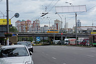 Traffic junction on Lybidska Square
 -
 Entrance to Lybidska metro station
 -
 The Pyrohiv museum is located within the raion


References
- ^ "Рідні мови в об'єднаних територіальних громадах України" (in Ukrainian).
External links
- Holosiivskyi District Administration website (in Ukrainian)
- Голосіїв in Wiki-Encyclopedia Kyiv (in Ukrainian)
- v
- t
- e
| Right-bank |
|
|---|---|
| Islands | |
| Left-bank |
|
- 1Unofficial designation
- Category:Urban districts of Kyiv
- Category:Neighborhoods in Kyiv
50°20′20″N 30°33′15″E / 50.33889°N 30.55417°E / 50.33889; 30.55417
Authority control databases | |
|---|---|
| International |
|
| National |
|
 | This article about a location in the city of Kyiv is a stub. You can help Wikipedia by expanding it. |
- v
- t
- e


