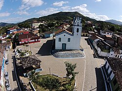
Iporanga | |
|---|---|
 | |
 Location in São Paulo state | |
| Coordinates: 24°35′08″S 48°35′35″W / 24.58556°S 48.59306°W | |
| Country | Brazil |
| Region | Southeast |
| State | São Paulo |
| Area | |
• Total | 1,152 km2 (445 sq mi) |
| Elevation | 81 m (266 ft) |
| Population (2020 [1]) | |
• Total | 4,199 |
| • Density | 3.6/km2 (9.4/sq mi) |
| Time zone | UTC−3 (BRT) |
Iporanga is a municipality in the state of São Paulo in Brazil. The population is 4,199 (2020 est.) in an area of 1152 km2.[2] The elevation is 81 m.
Iporanga contains parts of the Alto Ribeira and Baixo Ribeira sub-basins of the Ribeira de Iguape River basin.[3] The municipality contains part of the 488,865 hectares (1,208,010 acres) Serra do Mar Environmental Protection Area, created in 1984.[4] It contains part of the 41,704 hectares (103,050 acres) Intervales State Park, created in 1995.[5] It contains part of the 40,175 hectares (99,270 acres) Caverna do Diabo State Park, created in 2008.[6] It contains 55% of the 64,625 hectares (159,690 acres) Quilombos do Médio Ribeira Environmental Protection Area, established in 2008.[7]
Media
[edit]In telecommunications, the city was served by Companhia de Telecomunicações do Estado de São Paulo until 1975, when it began to be served by Telecomunicações de São Paulo.[8] In July 1998, this company was acquired by Telefónica, which adopted the Vivo brand in 2012.[9]
The company is currently an operator of cell phones, fixed lines, internet (fiber optics/4G) and television (satellite and cable).[9]
See also
[edit]References
[edit]- ^ IBGE 2020
- ^ Instituto Brasileiro de Geografia e Estatística
- ^ Almeida, Camilo Aparecido (26 January 2012), "Bacia Hidrográfica do Rio Ribeira de Iguape", O Vale do Ribeira, retrieved 2016-11-21
- ^ APA da Serra do Mar (APA) (in Portuguese), ISA: Instituto Socioambiental, retrieved 2016-12-08
{{citation}}: CS1 maint: publisher location (link) - ^ Furlan, Sueli Ângelo; Leite, Sandra Aparecida (2008), "Resumo Executivo", Parque Estadual Intervales: Plano de Manejo (PDF) (in Portuguese), Fundação Florestal, p. 33, retrieved 2016-12-06[permanent dead link]
- ^ Parque Estadual Caverna do Diabo (in Portuguese), MMA: Ministério do Meio Ambiente, retrieved 2016-11-21
{{citation}}: CS1 maint: publisher location (link) - ^ APA dos Quilombos do Médio Ribeira, ISA: Instituto Socioambiental, retrieved 2016-11-21
{{citation}}: CS1 maint: publisher location (link) - ^ "Creation of Telesp - April 12, 1973". www.imprensaoficial.com.br (in Portuguese). Retrieved 2024-05-26.
- ^ a b "Our History - Telefônica RI". Telefônica. Retrieved 2024-05-26.


