Jelovarnik
Waterfall in Serbia
| Jelovarnik waterfall | |
|---|---|
 | |
 | |
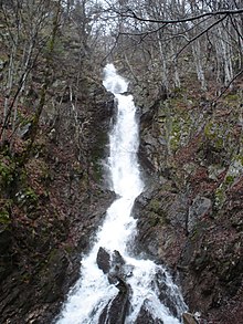
| Location | Kopaonik, Serbia |
| Total height | 71 m (233 ft) |
| Number of drops | 3 |
Jelovarnik is the second waterfall in Serbia by height, with total of 71 meters.[1] It is located in the area of Kopaonik national park Jelovarnik, after which it is named. Jelovarnik has elevation of 1,116 meters, and it is approximately 2,5 km east of Pančićev vrh. It was discovered by a group of geologists in 1998, while it was previously known only to the local community. The waterfall is located in a thick forest full of Balkan maple, beech and spruce. Jelovarnik is a natural park, together with accompasing flora and fauna, with total of 57 hectares.[2]
See more
- Geography of Serbia
References
Wikimedia Commons has media related to Jelovarnik Waterfalls.
- v
- t
- e
- Đerdap
- Fruška Gora
- Kopaonik
- Šar Mountains
- Tara
- Bagremara
- Brzansko Moravište
- Bukovo
- Stari Begej – Carska Bara
- Danilova kosa
- Deliblato Sand
- Goč
- Gornje Podunavlje
- Jelašnička river Gorge
- Jerma
- Karađorđevo
- Koviljsko-petrovaradinski rit
- Kraljevac
- Lake Ludaš
- Obedska bara
- Okanj
- Osredak
- Pastures of the Great Bustard
- Prebreza
- Prokop
- Selevenjske pustare
- Slano Kopovo
- Suva Planina
- Titelski Breg
- Trešnjica river Gorge
- Uvac
- Venerina padina
- Vinatovača
- Zasavica
- Begečka jama
- Golija
- Grmija
- Jegrička
- Kamaraš
- Šargan - Mokra Gora
- Lake Palić
- Ponjavica
- Sićevo Gorge
- Stara Planina
- Tikvara
- Stara Tisa
- Zlatibor
outstanding features
- Avala
- Đetinja Gorge
- Gradac Gorge
- Kamena Gora
- Kosmaj
- Ćelije hydroacumulation
- Mali Rzav Springs
- Miruša Waterfalls
- Ovčar-Kablar Gorge
- River Pčinja Valley
- Radan
- Lepterija - Soko Grad
- Ras - *Sopoćani
- Subotička Peščara
- Veliko Ratno Ostrvo
- Vlasina
- Vršac Mountains
- Zaovine
(selection)
 | This Serbia location article is a stub. You can help Wikipedia by expanding it. |
- v
- t
- e


