Kamensky District, Altai Krai
District in Altai Krai, Russia
Kamensky District Каменский район | |
|---|---|
District | |
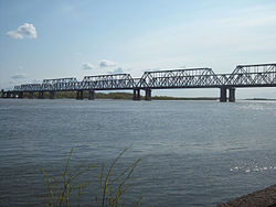 Bridge over the Ob River in Kamen-na-Obi, the administrative center of the district | |
 Coat of arms | |
 Location of Kamensky District in Altai Krai | |
| Coordinates: 53°48′N 81°21′E / 53.800°N 81.350°E / 53.800; 81.350 | |
| Country | Russia |
| Federal subject | Altai Krai[1] |
| Established | 9 December 1925 |
| Administrative center | Kamen-na-Obi[1] |
| Area | |
| • Total | 3,666 km2 (1,415 sq mi) |
| Population (2010 Census)[3] | |
| • Total | 12,025 |
| • Estimate (2018)[4] | 51,405 (+327.5%) |
| • Density | 3.3/km2 (8.5/sq mi) |
| • Urban | 0% |
| • Rural | 100% |
| Administrative structure | |
| • Administrative divisions | 1 Towns of district significance, 13 Selsoviets |
| • Inhabited localities[1] | 33 rural localities |
| Municipal structure | |
| • Municipally incorporated as | Kamensky Municipal District[5] |
| • Municipal divisions[5] | 1 urban settlements, 13 rural settlements |
| Time zone | UTC+7 (MSK+4 |
| OKTMO ID | 01616000 |
| Website | http://kamenrai.ru |
| 2010 Census | 12,025[3] |
|---|---|
| 2002 Census | 16,600[7] |
| 1989 Census | 16,977[8] |
| 1979 Census | 18,801[9] |
Kamensky District (Russian: Ка́менский райо́н) is an administrative[1] and municipal[5] district (raion), one of the fifty-nine in Altai Krai, Russia. It is located in the north of the krai and borders Krutikhinsky and Suzunsky Districts of Novosibirsk Oblast in the north, Shelabolikhinsky District in the east, Bayevsky and Tyumentsevsky Districts in the south, and Pankrushikhinsky District in the west. The area of the district is 3,666 square kilometers (1,415 sq mi).[2] Its administrative center is the town of Kamen-na-Obi.[1] As of the 2010 Census, the total population of the district was 12,025.[3]
Geography
The district is located on the northern border of Altai Krai, straddling the Ob River, which runs through the district from east to west as it makes its turn to the north. The terrain is hilly steppe on the Priobsky Plateau. Besides the Ob, the district is also watered by the Kulundinsky Canal, which has its head pumping station in Kamen-no-Obi. While much of the area is agricultural land, there are forests in the east on the meandering Ob floodplain, as well as numerous fresh and saltwater lakes. The soils are medium chernozem (black),sandy soils. The regional city of Barnaul is 125 km to the east.[2]
Climate
Average temperature in January is −19.7 °C (−3.5 °F), and average July temperature is 18.9 °C (66.0 °F). Annual precipitation is 330 millimeters (13 in).[2] The climate is Humid continental climate, cool summer, (Dfb). This climate is characterized by large swings in temperature, both diurnally and seasonally, with mild summers and cold, snowy winters.
Economy
Employment in the district is focused on food processing and agriculture.[2]
References
Notes
- ^ a b c d e Law #28-ZS
- ^ a b c d e "About the District" (in Russian). Kamensky District. Retrieved May 19, 2017.
- ^ a b c Russian Federal State Statistics Service (2011). Всероссийская перепись населения 2010 года. Том 1 [2010 All-Russian Population Census, vol. 1]. Всероссийская перепись населения 2010 года [2010 All-Russia Population Census] (in Russian). Federal State Statistics Service.
- ^ "26. Численность постоянного населения Российской Федерации по муниципальным образованиям на 1 января 2018 года". Federal State Statistics Service. Retrieved January 23, 2019.
- ^ a b c Law #41-ZS
- ^ "Об исчислении времени". Официальный интернет-портал правовой информации (in Russian). June 3, 2011. Retrieved January 19, 2019.
- ^ Russian Federal State Statistics Service (May 21, 2004). Численность населения России, субъектов Российской Федерации в составе федеральных округов, районов, городских поселений, сельских населённых пунктов – районных центров и сельских населённых пунктов с населением 3 тысячи и более человек [Population of Russia, Its Federal Districts, Federal Subjects, Districts, Urban Localities, Rural Localities—Administrative Centers, and Rural Localities with Population of Over 3,000] (XLS). Всероссийская перепись населения 2002 года [All-Russia Population Census of 2002] (in Russian).
- ^ Всесоюзная перепись населения 1989 г. Численность наличного населения союзных и автономных республик, автономных областей и округов, краёв, областей, районов, городских поселений и сёл-райцентров [All Union Population Census of 1989: Present Population of Union and Autonomous Republics, Autonomous Oblasts and Okrugs, Krais, Oblasts, Districts, Urban Settlements, and Villages Serving as District Administrative Centers]. Всесоюзная перепись населения 1989 года [All-Union Population Census of 1989] (in Russian). Институт демографии Национального исследовательского университета: Высшая школа экономики [Institute of Demography at the National Research University: Higher School of Economics]. 1989 – via Demoscope Weekly.
- ^ Всесоюзная перепись населения 1979 г. Национальный состав населения по регионам России [All Union Population Census of 1979. Ethnic composition of the population by regions of Russia] (XLS). Всесоюзная перепись населения 1979 года [All-Union Population Census of 1979] (in Russian). 1979 – via Demoscope Weekly (website of the Institute of Demographics of the State University—Higher School of Economics.
Sources
- Алтайский краевой Совет народных депутатов. Закон №28-ЗС от 1 марта 2008 г. «Об административно-территориальном устройстве Алтайского края», в ред. Закона №16-ЗС от 4 апреля 2017 г. «О присоединении станции Железнодорожная Казарма 572 км к посёлку Октябрьскому Октябрьского сельсовета Кулундинского района Алтайского края и внесении изменений в отдельные законы Алтайского края». Вступил в силу 8 марта 2008 г. Опубликован: "Алтайская правда", №67, 8 марта 2008 г. (Altai Krai Council of People's Deputies. Law #28-ZS of March 1, 2008 On the Administrative-Territorial Structure of Altai Krai, as amended by the Law #16-ZS of April 4, 2017 On Merging the Station of Zheleznodorozhnaya Kazarma 572 km into the Settlement of Oktyabrsky in Oktyabrsky Selsoviet of Kulundinsky District of Altai Krai and on Amending Various Laws of Altai Krai. Effective as of March 8, 2008.).
- Алтайский краевой Совет народных депутатов. Закон №41-ЗС от 8 мая 2007 г. «О статусе и границах муниципальных и административно-территориальных образований Каменского района Алтайского края», в ред. Закона №71-ЗС от 2 сентября 2015 г. «О внесении изменений в Закон Алтайского края "О статусе и границах муниципальных и административно-территориальных образований Каменского района Алтайского края"». Вступил в силу через 10 дней после дня официального опубликования. Опубликован: "Алтайская правда", №150 (без приложений), 24 мая 2007 г. (Altai Krai Council of People's Deputies. Law #41-ZS of May 8, 2007 On the Status and the Borders of the Municipal and the Administrative-Territorial Formations of Kamensky District of Altai Krai, as amended by the Law #71-ZS of September 2, 2015 On Amending the Law of Altai Krai "On the Status and the Borders of the Municipal and the Administrative-Territorial Formations of Kamensky District of Altai Krai". Effective as of after 10 days from after the day of the official publication.).
- v
- t
- e

- Aleysky
- Altaysky
- Bayevsky
- Biysky
- Blagoveshchensky
- Burlinsky
- Bystroistoksky
- Charyshsky
- Kalmansky
- Kamensky
- Khabarsky
- Klyuchevsky
- Kosikhinsky
- Krasnogorsky
- Krasnoshchyokovsky
- Krutikhinsky
- Kulundinsky
- Kuryinsky
- Kytmanovsky
- Loktevsky
- Mamontovsky
- Mikhaylovsky
- Nemetsky (German) National
- Novichikhinsky
- Pankrushikhinsky
- Pavlovsky
- Pervomaysky
- Petropavlovsky
- Pospelikhinsky
- Rebrikhinsky
- Rodinsky
- Romanovsky
- Rubtsovsky
- Shelabolikhinsky
- Shipunovsky
- Smolensky
- Soloneshensky
- Soltonsky
- Sovetsky
- Suyetsky
- Tabunsky
- Talmensky
- Togulsky
- Topchikhinsky
- Tretyakovsky
- Troitsky
- Tselinny
- Tyumentsevsky
- Uglovsky
- Ust-Kalmansky
- Ust-Pristansky
- Volchikhinsky
- Yegoryevsky
- Yeltsovsky
- Zalesovsky
- Zarinsky
- Zavyalovsky
- Zmeinogorsky
- Zonalny


