Karadag Nature Reserve
Nature reserve in Crimea
44°56′09″N 35°13′59″E / 44.93583°N 35.23306°E / 44.93583; 35.23306 Ramsar Wetland

Karadag Nature Reserve (Ukrainian: Карада́зький приро́дний запові́дник) (Russian: Карадагский природный заповедник) is a protected nature reserve that covers a portion of the southeast coast of the Crimean peninsula. Encompassing mountains, forest-steppe, shoreline and marine areas, Karadag is an area of high biodiversity and the subject of much scientific study throughout the past 100 years. It supports a high number of Crimea's endemic species, and important bird colonies. The reserve is 36 km southwest of the city of Feodosia, and is currently administered by the Russian Academy of Sciences.[2]
Topography
The Karadag Reserve is located in on the southeast coast of the Crimean Peninsula, in the Black Sea, on the eastern tip of the Crimean Mountains. The site is on the Kara Dag Mountain, a volcanic massif that formed in the Jurassic. The southern shores of the mountains slope down to the sea, creating an 8 km shoreline of bays, beaches, and grottoes. 809 hectares of the site covers off-shore marine areas. The marine sector plus the pebble-boulder beach and the coastal cliffs up to 120 meters, are a Ramsar wetland of international importance. The reserve is bracketed by the coastal towns of Koktebel on the north, and Kurortne to the south.[3]

Climate and ecoregion
The climate of Karadag is humid continental climate - hot summer sub-type (Köppen climate classification Dfa), with large seasonal temperature differentials and a hot summer (at least one month averaging over 22 °C (72 °F)) and mild winters.[4][5] The average temperature in the reserve in February is 1.5 °C (34.7 °F), and 23.8 °C (74.8 °F) in July. The water temperature varies from 5 °C (41 °F) to 22 °C (72 °F). Annual sunshine averages 2,200-2,300 hours per year, and annual precipitation averages 300 mm.[3]
The reserve is in the western extreme of the Crimean Submediterranean forest complex ecoregion, a small band of territory that stretches from the southern Crimean peninsula to the northern Caucasus Mountains.[6]
Flora and fauna
Because of its variety of habitat and position on both mountain and coast, the area is one of great biodiversity. Over half of the plant and animal species of Crimea are found in the Karadag Reserve, and one third of Crimea's endemic species. 40% of the reserve is forested, mostly with hornbeam, ash, pine and oak. Eight types of feather-grass steppe make up most of the rest. Scientists have recorded 1,154 species of vascular plants, 115 species of fish, 35 of mammals, and 236 species of birds. The area is particularly important for fish-eating birds, including a significant colony of European shag (a type of cormorant) on the cliffs.[3]
Public use
As a strict nature reserve, Kara-Dag's primary purpose is protection of nature and scientific study. Public access is limited: mass recreation and construction of facilities is prohibited as are hunting and fishing. There is an ecological trail (hiking) through the mountainous part of the reserve, recording over 15,000 users per year.[3] In the nearby village of Kurortne the reserve administers an ecological visitors center with wildlife and plant exhibits, and a dolphinarium (aquarium and center for dolphin study).[7] Reserve scientists and staff sponsor educational programs and publications. .[2]
Gallery
-
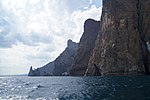 Karadag cliffs
 -
 Karadag coastline
 -
 Karadag cliffs by the sea
 -
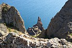
 View from the top
 -
 Jurassic cliffs, View from the top


See also
- Lists of Nature Preserves of Ukraine (class Ia protected areas)
- National Parks of Ukraine (class II protected areas)
References
- ^ "Aquatic-cliff complex of Karadag". Ramsar Sites Information Service. Retrieved 10 September 2019.
- ^ a b "Karadag Nature Reserve" (in Ukrainian). Official Reserve Website. Retrieved June 18, 2019.
- ^ a b c d "Aquatic-cliff complex of Karadag" (PDF). Ramsar Convention. Retrieved June 28, 2019.
- ^ Kottek, M.; Grieser, J.; Beck, C.; Rudolf, B.; Rubel, F. (2006). "World Map of Koppen-Geiger Climate Classification Updated" (PDF). Gebrüder Borntraeger 2006. Retrieved September 14, 2019.
- ^ "Dataset - Koppen climate classifications". World Bank. Retrieved September 14, 2019.
- ^ "Map of Ecoregions 2017". Resolve, using WWF data. Retrieved September 14, 2019.
- ^ "Reserve Karadag, Koktebel" (in Ukrainian). Koktebel. Retrieved June 29, 2019.
External links
- Boundaries of Kara-Dag Nature Reserve on OpenStreetMap.org
- Topographical site map of Kara-Dag Nature Reserve at Ramsar Convention website
Wikimedia Commons has media related to Kara-Dag Nature Reserve.
- v
- t
- e

- Azov-Syvash
- Bile Ozero
- Boikivshchyna
- Bug Gard
- Carpathian
- Charming Harbor
- Cheremosh
- Derman-Ostroh
- Desna-Stara Huta
- Dniester Canyon
- Dvorichna
- Dzharylhach
- Grand Meadow
- Halych
- Hetman
- Holosiiv
- Holy Mountains
- Homilsha Woods
- Hutsulshchyna
- Ichnia
- Ivory Coast of Sviatoslav
- Kamianska Sich
- Karmeliukove Podillia
- Kholodnyi Yar
- Khotyn
- Kremenets Mountains
- Kreminna Woods
- Kuialnyk
- Lower Dnieper
- Lower Dniester
- Lower Polissia
- Lower Sula
- Meotyda
- Mezyn
- Nobel
- Northern Podillia
- Oleshky Sands
- Podilian Tovtry
- Pryazovskyi
- Prypiat-Stokhid
- Pushcha Radzivila
- Pyriatyn
- Royal Beskids
- Shatsk
- Skole Beskids
- Sloboda
- Synevyr
- Syniohora
- Tsumanska Pushcha
- Tuzly Lagoons
- Upper Pobuzhzhia (proposed)
- Uzh
- Verkhovyna
- Vyzhnytsia
- Yavoriv
- Zacharovanyi Krai
- Zalissia
| Authority control databases |
|
|---|


