
Karl Johans gate is the main street of the city of Oslo, Norway. The street was named in honor of King Charles III John, who was also King of Sweden as Charles XIV John.[1]
Karl Johans gate is a composite of several older streets that used to be separate thoroughfares. The eastern section was part of Christian IV's original city near the ramparts surrounding the city. When the ramparts were removed to make way for Oslo Cathedral, three separate sections eventually became Østre Gade.
The wider western section was built during the 1840s as an avenue connecting the newly erected Norwegian Royal Palace with the rest of the city. In 1852, it was named Karl Johans gate in honor of the recently deceased king. His equestrian statue, by sculptor Brynjulf Bergslien, was later erected during 1875 in front of the Royal Palace. When the Norwegian parliament building was completed in 1866 at the junction of the two formerly separate streets, the two streets were joined and the whole length was named Karl Johans gate.[2]
-
 Karl Johans gate in the 1890s
 -
 Eidsvolls plass
 -
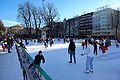 Spikersuppa
 -
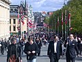 Karl Johans gate
in spring (Norwegian Constitution Day, 17 May) -
 Karl Johans gate
in winter -
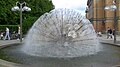 A fountain next to Karl Johans Gate in early summer
 -
 Elsa Laulan gæjnoe


See also
[edit]References
[edit]| International | |
|---|---|
| National | |
| Geographic | |
| Other | |