Kingsmead, Bath
Electoral ward in Bath, United Kingdom
Human settlement in England
- Somerset
- South West
- Bath

Kingsmead is an electoral ward within Bath, England, which encompasses most of Bath city centre and stretches west along the A4 to meet Newbridge and Weston wards. The ward elects two councillors to the Bath and North East Somerset unitary authority.[2]
Kingsmead is rarely used as the name of an area of Bath, and is primarily used for electoral purposes.[3] The ward stretches about 1 mile (1.6 km) westward from Bath city centre, straddling the A4 road north of the River Avon. The ward is separated by the large Royal Victoria Park into a city centre eastern end, and a western residential end known as Lower Weston.[4]
A boundary review in 2018, which came into force at the May 2019 local elections, abolished Abbey ward and extended Kingsmead eastwards as far as the Avon to include most of the city centre. At the same time the ward's western extent was slightly reduced, in order to move the Chelsea Road shopping street wholly into Newbridge ward.[2][5]
Residents in the western end of the ward often use the facilities, such as schools, of the neighbouring Newbridge and Weston wards, and associate themselves with these localities.[4]
The closed Mangotsfield and Bath Branch Line formerly ran from Green Park station, now a shopping area, in the ward. The Bristol & Bath Railway Path runs through the ward, but on the River Avon path rather than the former railway track which has been developed upon just south of the ward.
The electoral wards surrounding the ward are: Newbridge to the west, Weston and Lansdown to the north, Walcot and Bathwick to the east, and Widcombe & Lyncombe, Oldfield Park and Westmoreland to the south over the River Avon.[4]
Notable places
Notable places within the ward, from east to west, include:
- SouthGate shopping centre
- Guildhall
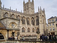
- Bath Abbey
- Roman Baths
- Theatre Royal
- Kingsmead Square
- Queen Square
- Bath Royal Literary and Scientific Institution
- Circus
- Herschel Museum of Astronomy
- Royal Crescent
- Norfolk Crescent
- Royal Victoria Park and Botanical Gardens
References
- ^ "Ward population 2011". Retrieved 7 April 2015.
- ^ a b "Bath & North East Somerset". Local Government Boundary Commission for England. Retrieved 26 April 2019.
- ^ "The Avon (Structural Change) Order 1995". legislation.gov.uk. The National Archives. Retrieved 19 March 2011.
- ^ a b c "Final recommendations published for new ward boundaries across B&NES". Bath Echo. 7 August 2018. Retrieved 26 April 2019.
- ^ "Bath & North East Somerset Council Elections, Thursday 2 May 2019". Bath & North East Somerset Council. March 2019. Retrieved 10 April 2019.
External links
- Ward Profile - Kingsmead, Bath and North East Somerset
- v
- t
- e
- Bath Abbey
- Bath Assembly Rooms
- Camden Crescent
- The Circus
- Cleveland Bridge
- Cleveland Pools
- The Corridor
- Cross Bath
- Empire Hotel
- The Forum
- Grand Pump Room
- Guildhall
- Lansdown Crescent
- Octagon Chapel
- The Paragon
- Prior Park
- Pulteney Bridge
- Queen Square
- Roman Baths
- Royal Crescent
- Somerset Place
- Victoria Bridge
- Widcombe Crescent
- Bath College
- Bath School of Art and Design
- Bath Spa University
- Beechen Cliff School
- Hayesfield Girls' School
- King Edward's School
- Kingswood School
- Prior Park College
- Monkton Combe School
- Norland College
- Oldfield School
- Royal High School
- Royal National Hospital for Rheumatic Diseases
- Royal United Hospital
- Ralph Allen School
- Saint Gregory's Catholic College
- St Mark's School
- University of Bath
- See also
- List of people from Bath


