| Kurekchay | |
|---|---|
 | |
 | |
| Native name | Kürəkçay (Azerbaijani) |
| Location | |
| Country | Azerbaijan |
| Region | Caucasus |
| District | Goranboy, Goygol, Yevlakh |
| Physical characteristics | |
| Source | Lesser Caucasus |
| • location | Azerbaijan |
| • coordinates | 40°18′35″N 46°14′4″E / 40.30972°N 46.23444°E |
| Mouth | Kura |
• location | Azerbaijan |
• coordinates | 40°43′30″N 47°02′29″E / 40.7251°N 47.0414°E |
| Length | 186 km (116 mi)[1] |
| Discharge | |
| • location | directly downstream into Kura |
| Basin features | |
| Progression | Kura→ Caspian Sea |
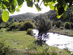
The Kurekchay (Azerbaijani: Kürəkçay) is one of the tributaries of the Kura River located in northwestern Azerbaijan.
History
[edit]On 14 May 1805, on the bank of the river (not far from Ganja), the signing of the Treaty of Kurakchay took place, which transferred the Karabakh Khanate to Russian control.[2]
See also
[edit]References
[edit]- ^ "Azərbaycanın çayları - Azərbaycan Coğrafiya Cəmiyyəti". gsaz.az. Retrieved 2017-10-31.
- ^ "Kurekchay Treaty" (PDF). Ministry of Justice of The Republic of Azerbaijan. 1805.
Wikimedia Commons has media related to Kürəkçay.