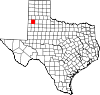
Lamb County, Texas
County in Texas, United States
County in Texas
34°04′N 102°21′W / 34.07°N 102.35°W / 34.07; -102.35 United States
 Texas
Texas (2020)
Lamb County is a county located in the U.S. state of Texas. As of the 2020 census, its population was 13,045.[1] Its county seat is Littlefield.[2] The county was created in 1876, but not organized until 1908.[3] It is named for George A. Lamb, who died in the Battle of San Jacinto.
Lamb County was the home of the Texas House Speaker Bill W. Clayton, who served from 1975 until 1983. It is also the birthplace of country music singer Waylon Jennings.
History
Lamb County was formed in 1876 from portions of Bexar County. It was named after George A. Lamb, a soldier in the Battle of San Jacinto.
In the 1960s, the water table began to decline. From the 1980s until 2023, the population declined by about 33%. Between circa 2013 and 2023, the population declined by about 8%.[4]
During the COVID-19 pandemic, Lamb County had an almost 1/100 death rate as of March 2023. As of that month, Lamb County, among American counties with 2,500 or more residents, had the eighth highest COVID-19 death rate.[4]
By 2023, there was water scarcity among farms, and many younger people moved to other counties for jobs.[4]
Geography
According to the U.S. Census Bureau, the county has a total area of 1,018 square miles (2,640 km2), of which 1.5 square miles (3.9 km2) (0.2%) are covered by water.[5]
Adjacent counties
- Castro County (north)
- Hale County (east)
- Hockley County (south)
- Bailey County (west)
- Parmer County (northwest)
- Lubbock County (southeast)
- Cochran County (southwest)
Demographics
| Census | Pop. | Note | %± |
|---|---|---|---|
| 1890 | 4 | — | |
| 1900 | 31 | 675.0% | |
| 1910 | 540 | 1,641.9% | |
| 1920 | 1,175 | 117.6% | |
| 1930 | 17,452 | 1,385.3% | |
| 1940 | 17,606 | 0.9% | |
| 1950 | 20,015 | 13.7% | |
| 1960 | 21,896 | 9.4% | |
| 1970 | 17,770 | −18.8% | |
| 1980 | 18,669 | 5.1% | |
| 1990 | 15,072 | −19.3% | |
| 2000 | 14,709 | −2.4% | |
| 2010 | 13,977 | −5.0% | |
| 2020 | 13,045 | −6.7% | |
| U.S. Decennial Census[6] 1850–2010[7] 2010[8] 2020[9] | |||
| Race / Ethnicity | Pop 2010[8] | Pop 2020[9] | % 2010 | % 2020 |
|---|---|---|---|---|
| White alone (NH) | 6,020 | 4,981 | 43.07% | 38.18% |
| Black or African American alone (NH) | 555 | 392 | 3.97% | 3.00% |
| Native American or Alaska Native alone (NH) | 39 | 15 | 0.28% | 0.11% |
| Asian alone (NH) | 17 | 4 | 0.12% | 0.03% |
| Pacific Islander alone (NH) | 4 | 5 | 0.03% | 0.04% |
| Some other race alone (NH) | 16 | 24 | 0.11% | 0.18% |
| Mixed race/multiracial (NH) | 95 | 175 | 0.68% | 1.34% |
| Hispanic or Latino (any race) | 7,231 | 7,449 | 51.73% | 57.10% |
| Total | 13,977 | 13,045 | 100.00% | 100.00% |
Note: the US Census treats Hispanic/Latino as an ethnic category. This table excludes Latinos from the racial categories and assigns them to a separate category. Hispanics/Latinos can be of any race.
As of the census[10] of 2000, 14,709 people, 5,360 households, and 3,991 families resided in the county. The population density was 14 people per square mile (5.4 people/km2). The 6,294 housing units averaged 6 units per square mile (2.3/km2). The racial makeup of the county was 76.1% White, 4.3% Black or African American, 0.7% Native American, 0.1% Asian, less than 0.05% Pacific Islander, 16.9% from other races, and 1.9% from two or more races. About 43.5% of the population was Hispanic or Latino of any race.
Of the 5,360 households, 35.4% had children under 18 living with them, 59.5% were married couples living together, 10.2% had a female householder with no husband present, and 25.5% were not families. About 23.7% of all households were made up of individuals, and 12.8% had someone living alone who was 65 years of age or older. The average household size was 2.69 and the average family size was 3.19.
In the county, the population was distributed as 29.6% under 18, 8.1% from 18 to 24, 24.2% from 25 to 44, 20.8% from 45 to 64, and 17.3% who were 65 age or older. The median age was 36 years. For every 100 females, there were 94.2 males. For every 100 females age 18 and over, there were 89.9 males.
The median income for a household in the county was $36,898, and for a family was $31,833. Males had a median income of $36,434 versus $30,342 for females. The per capita income for the county was $30,169. About 18.0% of families and 10.9% of the population were below the poverty line, including 27.3% of those under age 18 and 15.3% of those age 65 or over.
Transportation
Major highways
 U.S. Highway 70
 U.S. Highway 84
 U.S. Highway 385


Airports
Littlefield Municipal Airport is located in Lamb County, 3 nautical miles (5.6 km) west of the central business district of Littlefield, Texas.
Communities
Cities
- Amherst
- Earth
- Littlefield (county seat)
- Olton
- Sudan
Town
Census-designated place
Unincorporated community
Education
School districts serving the county include:[11]
- Amherst Independent School District
- Anton Independent School District
- Littlefield Independent School District
- Muleshoe Independent School District
- Olton Independent School District
- Springlake-Earth Independent School District
- Sudan Independent School District
- Whiteface Consolidated Independent School District
The county is in the service area of South Plains College.[12]
Media
As of 2023[update], there is one newspaper, Lamb County Leader-News, with three employees. An additional employee had died of COVID-19 in 2022, and the newspaper did not hire another individual.[4]
The Olton Enterprise, another newspaper, stopped publication in 2021.[13]
In 2023, Alejandro de la Garza wrote, in regards to the media landscape during the COVID-19 pandemic as the pandemic had caused damage to local media outlets, "for many residents, their Facebook feeds took the place of local media."[4]
Gallery
-
 Littlefield claims the world's tallest windmill.
 -
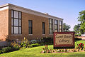 Lamb County Library in downtown Littlefield across from the First Baptist Church
 -
 Lamb County Leader-News in Littlefield
 -
 Lamb County Veterans Memorial
 -
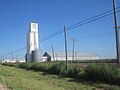 Littlefield Farmers Co-op grain elevator


Politics
| Year | Republican | Democratic | Third party | |||
|---|---|---|---|---|---|---|
| No. | % | No. | % | No. | % | |
| 2020 | 3,521 | 79.84% | 840 | 19.05% | 49 | 1.11% |
| 2016 | 3,111 | 77.87% | 771 | 19.30% | 113 | 2.83% |
| 2012 | 3,058 | 74.75% | 998 | 24.40% | 35 | 0.86% |
| 2008 | 3,344 | 73.90% | 1,156 | 25.55% | 25 | 0.55% |
| 2004 | 3,410 | 79.84% | 857 | 20.07% | 4 | 0.09% |
| 2000 | 3,451 | 75.05% | 1,114 | 24.23% | 33 | 0.72% |
| 1996 | 2,593 | 56.69% | 1,683 | 36.79% | 298 | 6.52% |
| 1992 | 2,998 | 55.01% | 1,737 | 31.87% | 715 | 13.12% |
| 1988 | 3,064 | 57.64% | 2,230 | 41.95% | 22 | 0.41% |
| 1984 | 3,892 | 66.78% | 1,919 | 32.93% | 17 | 0.29% |
| 1980 | 3,723 | 62.75% | 2,132 | 35.93% | 78 | 1.31% |
| 1976 | 2,413 | 41.50% | 3,374 | 58.02% | 28 | 0.48% |
| 1972 | 3,981 | 74.19% | 1,350 | 25.16% | 35 | 0.65% |
| 1968 | 2,595 | 41.05% | 2,267 | 35.86% | 1,460 | 23.09% |
| 1964 | 2,022 | 31.85% | 4,318 | 68.01% | 9 | 0.14% |
| 1960 | 2,764 | 46.01% | 3,089 | 51.42% | 154 | 2.56% |
| 1956 | 1,840 | 35.54% | 3,325 | 64.23% | 12 | 0.23% |
| 1952 | 2,913 | 51.36% | 2,748 | 48.45% | 11 | 0.19% |
| 1948 | 475 | 12.03% | 3,286 | 83.25% | 186 | 4.71% |
| 1944 | 616 | 17.89% | 2,407 | 69.89% | 421 | 12.22% |
| 1940 | 513 | 13.56% | 3,259 | 86.15% | 11 | 0.29% |
| 1936 | 300 | 11.41% | 2,320 | 88.21% | 10 | 0.38% |
| 1932 | 271 | 8.24% | 2,978 | 90.57% | 39 | 1.19% |
| 1928 | 1,266 | 74.21% | 440 | 25.79% | 0 | 0.00% |
| 1924 | 121 | 23.87% | 356 | 70.22% | 30 | 5.92% |
| 1920 | 136 | 32.46% | 264 | 63.01% | 19 | 4.53% |
| 1916 | 14 | 8.14% | 150 | 87.21% | 8 | 4.65% |
| 1912 | 6 | 7.14% | 53 | 63.10% | 25 | 29.76% |
In the 2020 U.S. presidential election, about 80% of the county's residents selected Donald Trump.[4]
Healthcare
In August 22, 43% of the county's residents had completed at least one COVID-19 vaccination series.[4]
See also
 Texas portal
- Recorded Texas Historic Landmarks in Lamb County
- Dry counties
- Plant X
- Llano Estacado
- West Texas
References
- ^ "Lamb County, Texas". United States Census Bureau. Retrieved February 23, 2021.
- ^ "Find a County". National Association of Counties. Retrieved June 7, 2011.
- ^ "Texas: Individual County Chronologies". Texas Atlas of Historical County Boundaries. The Newberry Library. 2008. Retrieved May 25, 2015.
- ^ a b c d e f g Garza, Alejandro de la (March 15, 2023). "In This Texas County, There's No Such Thing as Moving on From COVID-19". Time. Retrieved March 15, 2023.
[...] it's the 8th highest in the nation as of March 2023, excluding counties with fewer than 2,500 people.
- Alternate link at Yahoo! News - ^ "2010 Census Gazetteer Files". United States Census Bureau. August 22, 2012. Retrieved May 3, 2015.
- ^ "Decennial Census of Population and Housing by Decade". US Census Bureau.
- ^ "Texas Almanac: Population History of Counties from 1850–2010" (PDF). Texas Almanac. Archived (PDF) from the original on October 9, 2022. Retrieved May 3, 2015.
- ^ a b "P2 HISPANIC OR LATINO, AND NOT HISPANIC OR LATINO BY RACE - 2010: DEC Redistricting Data (PL 94-171) - Lamb County, Texas". United States Census Bureau.
- ^ a b "P2 HISPANIC OR LATINO, AND NOT HISPANIC OR LATINO BY RACE - 2020: DEC Redistricting Data (PL 94-171) - Lamb County, Texas". United States Census Bureau.
- ^ "U.S. Census website". United States Census Bureau. Retrieved May 14, 2011.
- ^ "2020 CENSUS - SCHOOL DISTRICT REFERENCE MAP: Lamb County, TX" (PDF). U.S. Census Bureau. Archived (PDF) from the original on October 9, 2022. Retrieved June 29, 2022. - Text list
- ^ Texas Education Code, Sec. 130.198. SOUTH PLAINS COLLEGE DISTRICT SERVICE AREA.
- ^ "Olton Enterprise ceased publication with June 25 edition". Texas Press Association. July 30, 2021. Retrieved March 15, 2023.
- ^ Leip, David. "Dave Leip's Atlas of U.S. Presidential Elections". uselectionatlas.org. Retrieved July 26, 2018.
External links
- Lamb County from the Handbook of Texas Online
- Lamb County Profile from the Texas Association of Counties
Places adjacent to Lamb County, Texas | ||||||||||||||||
|---|---|---|---|---|---|---|---|---|---|---|---|---|---|---|---|---|
| ||||||||||||||||


- v
- t
- e
Municipalities and communities of Lamb County, Texas, United States
County seat: Littlefield
community
- Texas portal
- United States portal
| |
|---|---|
Austin (capital) | |
| Topics | |
| Society | |
| Regions |
|
| Metropolitan areas |
|
| Counties | |
 Texas portal Texas portal | |
Authority control databases | |
|---|---|
| International |
|
| National |
|
| Other |
|
34°04′N 102°21′W / 34.07°N 102.35°W / 34.07; -102.35


