Lamoille, Nevada
Census-designated place in Nevada, United States
40°43′41″N 115°28′41″W / 40.72806°N 115.47806°W / 40.72806; -115.47806 (2020)
89828
Lamoille is a rural census-designated place in Elko County in the northeastern section of the state of Nevada in the western United States. As of the 2020 census it had a population of 276.[2] It is located 19 miles (31 km) southeast of Elko at the base of the Ruby Mountains at an elevation of 5,889 feet (1,795 m) and is part of the Elko Micropolitan Statistical Area.[3][4]
Demographics
| Census | Pop. | Note | %± |
|---|---|---|---|
| 2020 | 130 | — | |
| U.S. Decennial Census[5] | |||
History
The early history of the community and surrounding area is summarized in a nearby highway marker:[6]
LAMOILLE VALLEY - Because heavy use denuded the grass from the main Fort Hall route of the California Emigrant Trail along the Humboldt River, many emigrants left the river near Starr Valley. They skirted the East Humboldt Range and the Ruby Mountains along a Shoshone Indian path, rested their livestock in Lamoille Valley, and returned to the Humboldt River.
John Walker and Thomas Waterman first settled the area in 1865. Waterman named the valley after his native Vermont. In 1868, Walker erected the Cottonwood Hotel, store and blacksmith shop in the valley, and the settlement became known as "The Crossroads." Here wagons were repaired and food and supplies could be obtained. The original buildings and the more recent 20-bedroom Lamoille hotel, creamery, flour mill and dance hall are gone.
Lamoille is nestled off the western flanks of the Ruby Mountains at the end of Nevada State Route 227, and is the principal gateway to this range via the National Forest Scenic Byway up Lamoille Canyon. In 1907 a small church was constructed on the east side of the community, and is still in use today.
Former Disney president and good friend of Clint Eastwood, Frank Wells, died in a helicopter crash here in the Nevada Ruby Mountains.[7]
Climate
| Climate data for Lamoille 2N, Nevada, 1991–2020 normals: 5750ft (1753m) | |||||||||||||
|---|---|---|---|---|---|---|---|---|---|---|---|---|---|
| Month | Jan | Feb | Mar | Apr | May | Jun | Jul | Aug | Sep | Oct | Nov | Dec | Year |
| Record high °F (°C) | 59 (15) | 64 (18) | 76 (24) | 81 (27) | 88 (31) | 93 (34) | 95 (35) | 96 (36) | 93 (34) | 85 (29) | 70 (21) | 62 (17) | 96 (36) |
| Mean maximum °F (°C) | 48 (9) | 53 (12) | 64 (18) | 73 (23) | 79 (26) | 87 (31) | 92 (33) | 90 (32) | 86 (30) | 77 (25) | 65 (18) | 54 (12) | 92 (33) |
| Mean daily maximum °F (°C) | 35.3 (1.8) | 39.4 (4.1) | 47.8 (8.8) | 54.5 (12.5) | 63.3 (17.4) | 73.9 (23.3) | 83.8 (28.8) | 83.0 (28.3) | 74.3 (23.5) | 62.0 (16.7) | 46.8 (8.2) | 36.7 (2.6) | 58.4 (14.7) |
| Daily mean °F (°C) | 22.7 (−5.2) | 25.4 (−3.7) | 33.6 (0.9) | 39.5 (4.2) | 47.9 (8.8) | 56.3 (13.5) | 63.7 (17.6) | 61.7 (16.5) | 53.4 (11.9) | 42.6 (5.9) | 31.4 (−0.3) | 23.6 (−4.7) | 41.8 (5.5) |
| Mean daily minimum °F (°C) | 10.0 (−12.2) | 11.4 (−11.4) | 19.4 (−7.0) | 24.6 (−4.1) | 32.6 (0.3) | 38.7 (3.7) | 43.6 (6.4) | 40.5 (4.7) | 32.5 (0.3) | 23.2 (−4.9) | 15.9 (−8.9) | 10.4 (−12.0) | 25.2 (−3.8) |
| Mean minimum °F (°C) | −12 (−24) | −10 (−23) | 2 (−17) | 10 (−12) | 20 (−7) | 29 (−2) | 36 (2) | 30 (−1) | 19 (−7) | 9 (−13) | −3 (−19) | −11 (−24) | −19 (−28) |
| Record low °F (°C) | −30 (−34) | −20 (−29) | −18 (−28) | −3 (−19) | 10 (−12) | 23 (−5) | 29 (−2) | 24 (−4) | 13 (−11) | −6 (−21) | −22 (−30) | −24 (−31) | −30 (−34) |
| Average precipitation inches (mm) | 1.36 (35) | 1.30 (33) | 1.85 (47) | 2.29 (58) | 1.97 (50) | 1.01 (26) | 0.30 (7.6) | 0.48 (12) | 0.87 (22) | 1.14 (29) | 1.12 (28) | 1.19 (30) | 14.88 (377.6) |
| Average snowfall inches (cm) | 15.70 (39.9) | 14.10 (35.8) | 17.70 (45.0) | 10.40 (26.4) | 3.00 (7.6) | 0.20 (0.51) | 0.00 (0.00) | 0.00 (0.00) | 0.20 (0.51) | 1.80 (4.6) | 6.40 (16.3) | 14.90 (37.8) | 84.4 (214.42) |
| Source 1: NOAA[8] | |||||||||||||
| Source 2: XMACIS2 (records)[9] | |||||||||||||
Gallery
-
 Snow at the Hotel Lamoille
 -
 Cattle near Lamoille Canyon Road
 -
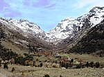 Lamoille Canyon


See also
References
- ^ "ArcGIS REST Services Directory". United States Census Bureau. Retrieved September 19, 2022.
- ^ "Explore Census Data". data.census.gov. Retrieved August 10, 2021.
- ^ "The Complete Traveler Guide to Lamoille". Retrieved December 7, 2009.
- ^ "Lamoille, NV Community Profile". HTL, Inc. Retrieved December 7, 2009.
- ^ "Census of Population and Housing". Census.gov. Retrieved June 4, 2016.
- ^ Sebesta, Paul. "HM 109 - Lamoille Valley." Nevada-Landmarks. 23 Sept. 2007. Web. 09 June 2012. <http://www.nevada-landmarks.com/el/shl109.htm Archived 2011-10-18 at the Wayback Machine>.
- ^ McGilligan, Patrick (1999). Clint: The Life and Legend. HarperCollins. ISBN 0-00-638354-8.
- ^ "Lamoille 2N, Nevada 1991-2020 Monthly Normals". Retrieved November 9, 2023.
- ^ "xmACIS". National Oceanic and Atmospheric Administration. Retrieved November 9, 2023.
External links
- Lamoille history
- Lamoille's Little Church of the Crossroads
Wikimedia Commons has media related to Lamoille, Nevada.
- v
- t
- e
Municipalities and communities of Elko County, Nevada, United States
County seat: Elko
- Jackpot
- Lamoille
- Mountain City
- Montello
- Oasis
- Osino
- Owyhee
- Spring Creek
unincorporated
communities
- Afton
- Alazon
- Black Forest
- Bullion
- Charleston
- Cobre
- Contact
- Cornucopia
- Cottonwood
- Delano
- Dinner Station
- Dutton
- Excelsior
- Fairlawn
- Fenelon
- Gold Creek
- Halleck
- Hunter
- Huntington
- Loray
- Metropolis
- Moleen
- Moor
- Ola
- Patsville
- Pequop
- Rio Tinto
- Ruby City
- San Jacinto
- Shafter
- Silver Zone
- Sprucemont
- Tobar
- Tulasco
- White Rock
‡This populated place also has portions in an adjacent county or counties
- Nevada portal
- United States portal
Authority control databases | |
|---|---|
| International |
|
| National |
|


