Lepuix
Commune in Bourgogne-Franche-Comté, France

Coat of arms
Location of Lepuix

(2020–2026) Daniel Roth[1]
1
(2021)[2]
90065 /90200
Lepuix (French pronunciation: [ləpɥi]) is a commune in the Territoire de Belfort department in Bourgogne-Franche-Comté in northeastern France.
Geography
Climate
Lepuix has a humid continental climate (Köppen climate classification Dfb). The average annual temperature in Lepuix is 6.3 °C (43.3 °F). The average annual rainfall is 2,387.7 mm (94.00 in) with December as the wettest month. The temperatures are highest on average in July, at around 14.5 °C (58.1 °F), and lowest in January, at around −1.2 °C (29.8 °F). The highest temperature ever recorded in Lepuix was 32.3 °C (90.1 °F) on 24 July 2019; the coldest temperature ever recorded was −19.1 °C (−2.4 °F) on 20 December 2009.
| Climate data for Ballon d'Alsace, Lepuix (1981–2010 averages, extremes 1987−present) | |||||||||||||
|---|---|---|---|---|---|---|---|---|---|---|---|---|---|
| Month | Jan | Feb | Mar | Apr | May | Jun | Jul | Aug | Sep | Oct | Nov | Dec | Year |
| Record high °C (°F) | 14.3 (57.7) | 17.0 (62.6) | 18.4 (65.1) | 22.5 (72.5) | 26.4 (79.5) | 29.7 (85.5) | 32.3 (90.1) | 31.3 (88.3) | 26.3 (79.3) | 22.4 (72.3) | 18.5 (65.3) | 13.8 (56.8) | 32.3 (90.1) |
| Mean daily maximum °C (°F) | 1.1 (34.0) | 1.5 (34.7) | 4.1 (39.4) | 8.7 (47.7) | 13.4 (56.1) | 16.8 (62.2) | 18.2 (64.8) | 17.9 (64.2) | 13.8 (56.8) | 10.2 (50.4) | 4.4 (39.9) | 1.4 (34.5) | 9.3 (48.7) |
| Daily mean °C (°F) | −1.2 (29.8) | −1.0 (30.2) | 1.3 (34.3) | 5.3 (41.5) | 9.7 (49.5) | 13.0 (55.4) | 14.5 (58.1) | 14.4 (57.9) | 10.6 (51.1) | 7.5 (45.5) | 2.2 (36.0) | −0.9 (30.4) | 6.3 (43.3) |
| Mean daily minimum °C (°F) | −3.6 (25.5) | −3.5 (25.7) | −1.5 (29.3) | 1.9 (35.4) | 6.1 (43.0) | 9.1 (48.4) | 10.7 (51.3) | 11.0 (51.8) | 7.4 (45.3) | 4.7 (40.5) | −0.1 (31.8) | −3.1 (26.4) | 3.3 (37.9) |
| Record low °C (°F) | −15.9 (3.4) | −18.8 (−1.8) | −15.7 (3.7) | −9.3 (15.3) | −3.6 (25.5) | −0.9 (30.4) | 3.9 (39.0) | 2.5 (36.5) | −0.2 (31.6) | −7.7 (18.1) | −13.8 (7.2) | −19.1 (−2.4) | −19.1 (−2.4) |
| Average precipitation mm (inches) | 243.3 (9.58) | 234.6 (9.24) | 221.1 (8.70) | 130.8 (5.15) | 186.4 (7.34) | 126.6 (4.98) | 163.8 (6.45) | 183.0 (7.20) | 164.6 (6.48) | 225.7 (8.89) | 226.5 (8.92) | 281.3 (11.07) | 2,387.7 (94.00) |
| Average precipitation days (≥ 1.0 mm) | 14.3 | 15.0 | 15.1 | 13.3 | 14.8 | 12.1 | 13.6 | 14.3 | 11.2 | 13.9 | 15.5 | 16.4 | 169.3 |
| Source: Meteociel[3] | |||||||||||||
Gallery
-
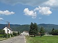 Lepuix, view to a village
 -
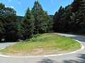 between Lepuix and Ballon d'Alsace, hairpin turn


See also
Wikimedia Commons has media related to Lepuix.
References
- ^ "Répertoire national des élus: les maires" (in French). data.gouv.fr, Plateforme ouverte des données publiques françaises. 13 September 2022.
- ^ "Populations légales 2021". The National Institute of Statistics and Economic Studies. 28 December 2023.
- ^ "Normales et records pour Ballon SAPC (90)". Meteociel. Retrieved 15 June 2022.
- v
- t
- e
Communes of the Territoire de Belfort department 

- Andelnans
- Angeot
- Anjoutey
- Argiésans
- Autrechêne
- Auxelles-Bas
- Auxelles-Haut
- Banvillars
- Bavilliers
- Beaucourt
- Belfortpref
- Bermont
- Bessoncourt
- Bethonvilliers
- Boron
- Botans
- Bourg-sous-Châtelet
- Bourogne
- Brebotte
- Bretagne
- Buc
- Charmois
- Châtenois-les-Forges
- Chaux
- Chavanatte
- Chavannes-les-Grands
- Chèvremont
- Courcelles
- Courtelevant
- Cravanche
- Croix
- Cunelières
- Danjoutin
- Delle
- Denney
- Dorans
- Eguenigue
- Éloie
- Essert
- Étueffont
- Évette-Salbert
- Faverois
- Fêche-l'Église
- Felon
- Florimont
- Fontaine
- Fontenelle
- Foussemagne
- Frais
- Froidefontaine
- Giromagny
- Grandvillars
- Grosmagny
- Grosne
- Joncherey
- Lachapelle-sous-Chaux
- Lachapelle-sous-Rougemont
- Lacollonge
- Lagrange
- Lamadeleine-Val-des-Anges
- Larivière
- Lebetain
- Lepuix
- Lepuix-Neuf
- Leval
- Menoncourt
- Meroux-Moval
- Méziré
- Montbouton
- Montreux-Château
- Morvillars
- Novillard
- Offemont
- Pérouse
- Petit-Croix
- Petitefontaine
- Petitmagny
- Phaffans
- Réchésy
- Recouvrance
- Reppe
- Riervescemont
- Romagny-sous-Rougemont
- Roppe
- Rougegoutte
- Rougemont-le-Château
- Saint-Dizier-l'Évêque
- Saint-Germain-le-Châtelet
- Sermamagny
- Sevenans
- Suarce
- Thiancourt
- Trévenans
- Urcerey
- Valdoie
- Vauthiermont
- Vellescot
- Vescemont
- Vétrigne
- Vézelois
- Villars-le-Sec
- pref: prefecture
- subpr: subprefecture
Authority control databases | |
|---|---|
| International |
|
| National |
|
 | This Territoire de Belfort geographical article is a stub. You can help Wikipedia by expanding it. |
- v
- t
- e


