List of Category A listed buildings in Glasgow

This is a list of Category A listed buildings in Glasgow, Scotland.
In Scotland, the term listed building refers to a building or other structure officially designated as being of "special architectural or historic interest".[1] Category A structures are those considered to be "buildings of national or international importance, either architectural or historic, or fine little-altered examples of some particular period, style or building type."[2] Listing was begun by a provision in the Town and Country Planning (Scotland) Act 1947, and the current legislative basis for listing is the Planning (Listed Buildings and Conservation Areas) (Scotland) Act 1997.[3] The authority for listing rests with Historic Scotland, an executive agency of the Scottish Government, which inherited this role from the Scottish Development Department in 1991. Once listed, severe restrictions are imposed on the modifications allowed to a building's structure or its fittings. Listed building consent must be obtained from local authorities prior to any alteration to such a structure.[3] There are approximately 47,400 listed buildings in Scotland, of which around 8% (some 3,800) are Category A.[4]
The medieval city of Glasgow formed around two axes, that of the High Street and the Saltmarket which was bisected by Trongate and Gallowgate at Glasgow Cross. Despite its ancient origins very little of the medieval fabric of the city survives. Only two buildings from the earliest period are extant in Glasgow; the Cathedral and the former canon’s house. Nor do the riggs and wynds of the old city remain, though a great deal of the original street pattern has persisted down the centuries. Additionally, a mere handful of buildings from the period between the Reformation and the end of the eighteenth century have come down to us.[5] The majority of the city’s building stock, then, is nineteenth century when the population of Glasgow rose from c. 78,000 in 1801 to 770,000 in 1901. The pattern of expansion can be traced from the commercial centre of the High Street and Merchant City westwards to the Blythswood Hill New Town laid out in the 1820s and 30s, and south of the river in Laurieston and Tradeston.[6] The feus of both these developments were, unusually for the British Isles, laid out on a gridiron pattern. Further development came with the construction of the Woodlands and Park District areas, the latter of which was the work of Charles Wilson, in the 1830s and 40s. With the relocation of the University from the High street to Gilmorehill in the 1860s came the expansion of the city to the west where suburbs at Dowanhill and Partickhill were laid out on the garden principal with villas and cottages in a number of styles.[7] Similarly, the coming of the railways and trams permitted the development of the suburbs of Pollokshields and Langside to the south. In 1866 the city corporation established the City Improvement Trust to control planning and clear slums. The outlying burghs were amalgamated into the City Corporation in 1891 and in the following decades the city witnessed its peak population of circa 1.1 million. With the post-war period came the proposals of the Bruce Plan in 1945 and the Clyde Valley Report in 1946. The former recommended the phased replacement of the entire city centre and its encirclement with a ring-road, of which scheme only the M8 at Charing Cross and Anderston was completed. The latter advised the displacement of the population of the City centre to New Towns and peripheral estates which led to the contraction of the city’s population and the wholesale redevelopment of areas such as the Gorbals and Townhead.[8]
The architectural character of Glasgow has been described as follows: “[t]he architecture of the City Centre exhibits a distinctive confidence from the late 18th century into the 21st century that makes it unique in Scotland. Although a variety of architectural styles exist, there are certain Glasgow characteristics: depth of modelling; wealth of ornamentation and sculpture; animated roofline; and consistent building lines and predominantly flat (not stepped or curved) linear elevations along the backs of the pavements. Glasgow architects and engineers were, and remain, frequent pioneers of new building technology and materials.”[9] Perhaps the most striking quality of Glasgow’s urban form is the eclectic mix of styles which it exhibits. Of those belonging to the early nineteenth century include: the neoclassicism of William Stark and David Hamilton; a vigorous tradition of Greek Revival, possibly the longest lasting in Britain, which persisted down to the 1890s;[10] Italianate evidenced in the Western Club and Rochead’s 2 St Vincent St.; and Gothic Revival notably practised by Leiper and G. Gilbert Scott. By the mid-century Glasgow had produced its first native architect of national and later international importance in Alexander Thomson, whose eclectic historicism produced its own school. Later nineteenth-century work includes the art nouveau inspired buildings of James Salmon, particularly the “Hatrack” on St Vincent St.; the Beaux arts style common to many public buildings of the period especially the City Chambers; Mackintosh’s art and crafts inflected work; Edwardian Baroque revival; and the distinctive free Glasgow Style of Millar and the later Salmon. The inter-war period sees the use of Art Deco and some reference to the Chicago Style in the elevator buildings demanded by commerce of the time, specifically in James Miller’s St Vincent St. Bank of Scotland and 98 West George Street. Post-war there is the creative application of Functionalism in the work of Jack Coia and Brutalism elsewhere in the city’s redevelopment. The best of Glasgow's historic architecture was metropolitan in its ambition, as the Buildings of Scotland remarks: “A visitor with time to spare will find that the city centre is rich with remarkable buildings from the height of its industrial prosperity and that its grandest suburbs are planned on a scale comparable with many European capitals.”[11]
Listed buildings
Map all coordinates using OpenStreetMap
Download coordinates as:
- KML
- GPX (all coordinates)
- GPX (primary coordinates)
- GPX (secondary coordinates)
| Name | Location | Date Listed | Grid Ref. [note 1] | Geo-coordinates | Notes | LB Number [note 2] | Image |
|---|---|---|---|---|---|---|---|
| Trinity College | 31, 33, 35 Lynedoch Street and 92, 96 Woodside Terrace Lane | 15 December 1970 | NS5766766228 | 55°52′05″N 4°16′34″W / 55.86814°N 4.276144°W / 55.86814; -4.276144 (Trinity College) | 1856 architect Charles Wilson. | 32171 |  Upload another image |
| Arlington Baths Club | 61 Arlington Street | 20 May 1986 | NS5785566510 | 55°52′15″N 4°16′24″W / 55.870727°N 4.27329°W / 55.870727; -4.27329 (Arlington Baths Club) | 1871 by John Burnet Senior. Additions by A Myles of 1893 and B Conner of 1902. | 32173 |  Upload another image |
| 1–12 Claremont Terrace [de] | Claremont Terrace | 15 December 1970 | NS5757166178 | 55°52′04″N 4°16′40″W / 55.867663°N 4.27765°W / 55.867663; -4.27765 (1–12 Claremont Terrace [de]) | John Baird I, architect; 1842-1847. No 6 built first as freestanding mansion in 1842. Remainder of Terrace added in 1847.Includes 1 Claremont Place, and gatepiers to Claremont Terrace Lane | 32185 | ![1–12 Claremont Terrace [de]](http://upload.wikimedia.org/wikipedia/commons/thumb/b/b4/Claremont_Terrace%2C_Glasgow.jpg/150px-Claremont_Terrace%2C_Glasgow.jpg) Upload another image |
| Great Western Road Bridge over River Kelvin | West End | 20 May 1986 | NS5746466972 | 55°52′29″N 4°16′47″W / 55.87476°N 4.279776°W / 55.87476; -4.279776 (Great Western Road Bridge over River Kelvin) | Bell and Miller, engineers; Morrison and Mason, contractors; Sir W Arrol, iron and steel work. Begun April 1890, opened September 1891. | 32197 |  Upload another image |
| St Mary's Episcopal Cathedral | 300 Great Western Road/Holyrood Crescent | 15 December 1970 | NS5776066827 | 55°52′25″N 4°16′30″W / 55.873545°N 4.274973°W / 55.873545; -4.274973 (St Mary's Episcopal Cathedral) | George Gilbert Scott, architect, 1871-8. Spire by John Oldrid Scott, completed 1893. | 32198 |  Upload another image |
| 445-459 (Odd Nos) Great Western Road [de] and 6 Caledonian Crescent, 1-8 (Inclusive Nos) Caledonian Mansions | 15 December 1970 | NS5738067001 | 55°52′30″N 4°16′52″W / 55.874995°N 4.281133°W / 55.874995; -4.281133 (445-459 (Odd Nos) Great Western Road [de] and 6 Caledonian Crescent, 1-8 (Inclusive Nos) Caledonian Mansions) | 1897-8 by James Millar. Free Arts and Crafts/ Glasgow Style terrace of tenements. | 32200 | ![445-459 (Odd Nos) Great Western Road [de] and 6 Caledonian Crescent, 1-8 (Inclusive Nos) Caledonian Mansions](http://upload.wikimedia.org/wikipedia/commons/thumb/1/19/445-459_%28Odd_Nos%29_Great_Western_Road_and_6_Caledonian_Crescent%2C_1-8_%28Inclusive_Nos%29_Caledonian_Mansions.jpg/150px-445-459_%28Odd_Nos%29_Great_Western_Road_and_6_Caledonian_Crescent%2C_1-8_%28Inclusive_Nos%29_Caledonian_Mansions.jpg) Upload another image | |
| Lansdowne Parish Church [de] (Church of Scotland) | 416 and 420 Great Western Road/433 North Woodside Road | 15 December 1970 | NS5756466941 | 55°52′28″N 4°16′41″W / 55.874511°N 4.278163°W / 55.874511; -4.278163 (Lansdowne Parish Church [de] (Church of Scotland)) | 1863, John Honeyman. Sculptor; John Mossman. | 32205 | ![Lansdowne Parish Church [de] (Church of Scotland)](http://upload.wikimedia.org/wikipedia/commons/thumb/f/f1/Lansdowne_Parish_Church_Glasgow.jpg/112px-Lansdowne_Parish_Church_Glasgow.jpg) Upload another image |
| Roberts Memorial [de] | Kelvingrove Park | 15 December 1970 | NS5731766480 | 55°52′13″N 4°16′55″W / 55.870299°N 4.281865°W / 55.870299; -4.281865 (Roberts Memorial [de]) | Unveiled in 1916; replica of monument by Harry Bates ARA in Calcutta to Field Marshal Earl Roberts, erected in 1915. | 32211 | ![Roberts Memorial [de]](http://upload.wikimedia.org/wikipedia/commons/thumb/e/e0/Glasgow_-_Lord_Roberts_memorial.jpg/150px-Glasgow_-_Lord_Roberts_memorial.jpg) Upload another image |
| Stewart Memorial Fountain [de] | Kelvingrove Park | 15 December 1970 | NS5718466234 | 55°52′05″N 4°17′02″W / 55.868051°N 4.283858°W / 55.868051; -4.283858 (Stewart Memorial Fountain [de]) | 1872 James Sellars, architect; John Mossman, sculptor; H Pringle & Co bronze founders. | 32213 | ![Stewart Memorial Fountain [de]](http://upload.wikimedia.org/wikipedia/commons/thumb/0/03/Stewart_Memorial_Fountain.jpg/112px-Stewart_Memorial_Fountain.jpg) Upload another image |
| 41-53 (Odd Nos) Oakfield Avenue [de] and 18 Great George Street | 15 December 1970 | NS5716566914 | 55°52′27″N 4°17′04″W / 55.87415°N 4.28452°W / 55.87415; -4.28452 (41-53 (Odd Nos) Oakfield Avenue [de] and 18 Great George Street) | 1865 by Alexander Thomson. | 32235 | ![41-53 (Odd Nos) Oakfield Avenue [de] and 18 Great George Street](http://upload.wikimedia.org/wikipedia/commons/thumb/7/70/41-53_%28Odd_Nos%29_Oakfield_Avenue_and_18_Great_George_Street.jpg/150px-41-53_%28Odd_Nos%29_Oakfield_Avenue_and_18_Great_George_Street.jpg) Upload another image | |
| 1-29 (Inclusive Nos) Park Circus and 9 Park Street South | Park District | 15 December 1970 | NS5754666408 | 55°52′11″N 4°16′41″W / 55.86972°N 4.27817°W / 55.86972; -4.27817 (1-29 (Inclusive Nos) Park Circus and 9 Park Street South) | 1855-6 by Charles Wilson. Nos 1-16 built 1857-9; Nos 18-22 built 1861-3 (No 22 by J Boucher 1872); Nos 23-29 built 1872-3. Includes 22 Park Circus, Glasgow | 32238 | 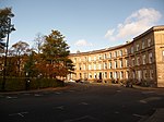 Upload another image |
| 1-17 (Odd Nos) and 2-8 (Even Nos) Park Circus Place [de] | Park District | 15 December 1970 | NS5756466296 | 55°52′07″N 4°16′40″W / 55.86872°N 4.277824°W / 55.86872; -4.277824 (1-17 (Odd Nos) and 2-8 (Even Nos) Park Circus Place [de]) | Charles Wilson, architect: designed 1855-6 built 1872-3. | 32239 | ![1-17 (Odd Nos) and 2-8 (Even Nos) Park Circus Place [de]](http://upload.wikimedia.org/wikipedia/commons/thumb/f/fb/Glasgow_-_Park_Circus_Place.jpg/100px-Glasgow_-_Park_Circus_Place.jpg) Upload another image |
| 1-6 (Inclusive Nos) Park Gardens and Park Gardens Lane [de] | Park District | 15 December 1970 | NS5741666220 | 55°52′05″N 4°16′49″W / 55.867994°N 4.280147°W / 55.867994; -4.280147 (1-6 (Inclusive Nos) Park Gardens and Park Gardens Lane [de]) | Charles Wilson, architect; circa 1855. | 32240 | ![1-6 (Inclusive Nos) Park Gardens and Park Gardens Lane [de]](http://upload.wikimedia.org/wikipedia/commons/thumb/7/7b/1-6_%28Inclusive_Nos%29_Park_Gardens_and_Park_Gardens_Lane%2C_Glasgow%2C_2018-06-27.jpg/150px-1-6_%28Inclusive_Nos%29_Park_Gardens_and_Park_Gardens_Lane%2C_Glasgow%2C_2018-06-27.jpg) Upload another image |
| Park Gardens, Stairway to Park Street South [de] | Park District | 15 December 1970 | NS5740766239 | 55°52′05″N 4°16′49″W / 55.868162°N 4.280301°W / 55.868162; -4.280301 (Park Gardens, Stairway to Park Street South [de]) | 1853-4, Charles Wilson. | 32241 | ![Park Gardens, Stairway to Park Street South [de]](http://upload.wikimedia.org/wikipedia/commons/thumb/5/56/Park_Gardens%2C_Stairway_to_Park_Street_South%2C_2018-06-27.jpg/150px-Park_Gardens%2C_Stairway_to_Park_Street_South%2C_2018-06-27.jpg) Upload another image |
| 1-5 (Odd Nos Inclusive) and 4 Park Gate [de] | Park District | 15 December 1970 | NS5741566393 | 55°52′10″N 4°16′49″W / 55.869547°N 4.280254°W / 55.869547; -4.280254 (1-5 (Odd Nos Inclusive) and 4 Park Gate [de]) | 1857-9, Charles Wilson. | 32242 | ![1-5 (Odd Nos Inclusive) and 4 Park Gate [de]](http://upload.wikimedia.org/wikipedia/commons/thumb/3/33/Park_Gate_-_geograph.org.uk_-_768921.jpg/150px-Park_Gate_-_geograph.org.uk_-_768921.jpg) Upload another image |
| 1-10 (Inclusive Nos) Park Quadrant [de] | Park District | 15 December 1970 | NS5746466489 | 55°52′14″N 4°16′46″W / 55.870423°N 4.279522°W / 55.870423; -4.279522 (1-10 (Inclusive Nos) Park Quadrant [de]) | Charles Wilson, architect; circa 1855-8. | 32243 | ![1-10 (Inclusive Nos) Park Quadrant [de]](http://upload.wikimedia.org/wikipedia/commons/thumb/0/0b/Glasgow_-_Park_Quadrant.jpg/100px-Glasgow_-_Park_Quadrant.jpg) Upload another image |
| 1-21 (Inclusive Nos) Park Terrace [de] and 18-24 (Inclusive Nos) Woodlands Terrace and 2-4 (Even Nos) Park Terrace East Lane and 3 Park Street South | Park District | 15 December 1970 | NS5746066293 | 55°52′07″N 4°16′46″W / 55.868663°N 4.279483°W / 55.868663; -4.279483 (1-21 (Inclusive Nos) Park Terrace [de] and 18-24 (Inclusive Nos) Woodlands Terrace and 2-4 (Even Nos) Park Terrace East Lane and 3 Park Street South) | Charles Wilson, 1855. | 32245 | ![1-21 (Inclusive Nos) Park Terrace [de] and 18-24 (Inclusive Nos) Woodlands Terrace and 2-4 (Even Nos) Park Terrace East Lane and 3 Park Street South](http://upload.wikimedia.org/wikipedia/commons/thumb/9/9c/Park_Terrace_-_geograph.org.uk_-_768917.jpg/150px-Park_Terrace_-_geograph.org.uk_-_768917.jpg) Upload another image |
| Park Terrace Balustrade Railings and Gateway [de] | Kelvingrove Park | 15 December 1970 | NS5735566447 | 55°52′12″N 4°16′52″W / 55.870014°N 4.28124°W / 55.870014; -4.28124 (Park Terrace Balustrade Railings and Gateway [de]) | Charles Wilson, architect, circa 1855. | 32246 | ![Park Terrace Balustrade Railings and Gateway [de]](http://upload.wikimedia.org/wikipedia/commons/thumb/9/92/Park_Terrace_Balustrade_Railings_and_Gateway.jpg/150px-Park_Terrace_Balustrade_Railings_and_Gateway.jpg) Upload another image |
| Stairway to Clifton Street [de] | Woodlands Terrace | 15 December 1970 | NS5748166227 | 55°52′05″N 4°16′45″W / 55.868076°N 4.279113°W / 55.868076; -4.279113 (Stairway to Clifton Street [de]) | Circa 1855. | 32267 | ![Stairway to Clifton Street [de]](http://upload.wikimedia.org/wikipedia/commons/thumb/c/c1/Glasgow_-_Stairway_to_Clifton_Street.jpg/150px-Glasgow_-_Stairway_to_Clifton_Street.jpg) Upload another image |
| 6-19 (Inclusive No) Woodside Crescent [de] | 15 December 1970 | NS5792766149 | 55°52′03″N 4°16′19″W / 55.867508°N 4.271951°W / 55.867508; -4.271951 (6-19 (Inclusive No) Woodside Crescent [de]) | 1831, George Smith. | 32268 | ![6-19 (Inclusive No) Woodside Crescent [de]](http://upload.wikimedia.org/wikipedia/commons/thumb/8/89/6-19_%28Inclusive_No%29_Woodside_Crescent.jpg/150px-6-19_%28Inclusive_No%29_Woodside_Crescent.jpg) Upload another image | |
| 1-28 (Inclusive Nos) Woodside Place [de] and 138, 140 Elderslie Street | 15 December 1970 | NS5786166098 | 55°52′01″N 4°16′23″W / 55.86703°N 4.272978°W / 55.86703; -4.272978 (1-28 (Inclusive Nos) Woodside Place [de] and 138, 140 Elderslie Street) | 1838, George Smith. | 32270 | ![1-28 (Inclusive Nos) Woodside Place [de] and 138, 140 Elderslie Street](http://upload.wikimedia.org/wikipedia/commons/thumb/3/3a/1-28_%28Inclusive_Nos%29_Woodside_Place_and_138%2C_140_Elderslie_Street.jpg/150px-1-28_%28Inclusive_Nos%29_Woodside_Place_and_138%2C_140_Elderslie_Street.jpg) Upload another image | |
| 1-22 (Inclusive Nos) Woodside Terrace [de], 11-63 Woodside Terrace Lane, 4 Claremount Place | 15 December 1970 | NS5774066180 | 55°52′04″N 4°16′30″W / 55.867731°N 4.274953°W / 55.867731; -4.274953 (1-22 (Inclusive Nos) Woodside Terrace [de], 11-63 Woodside Terrace Lane, 4 Claremount Place) | George Smith, architect. Nos 1-11, 1835; Nos 12-21, 1842. | 32271 | ![1-22 (Inclusive Nos) Woodside Terrace [de], 11-63 Woodside Terrace Lane, 4 Claremount Place](http://upload.wikimedia.org/wikipedia/commons/thumb/f/f5/Glasgow%2C_Woodside_Terrace_-_geograph.org.uk_-_1539316.jpg/150px-Glasgow%2C_Woodside_Terrace_-_geograph.org.uk_-_1539316.jpg) Upload another image | |
| North British Engine Works | 739 South Street | 22 August 1984 | NS5341566914 | 55°52′23″N 4°20′40″W / 55.873024°N 4.344401°W / 55.873024; -4.344401 (North British Engine Works) | J Galt architect, 1913-14. Steel framed, brick and glass building modelled on Peter Behren's A E G Turbine Factory in Berlin (1909). | 32280 | 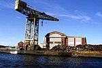 Upload another image |
| Former North British Diesel Engine Engine Works, Quayside Titan Crane | 739 South Street | 14 April 1989 | NS5334166844 | 55°52′21″N 4°20′44″W / 55.872373°N 4.345545°W / 55.872373; -4.345545 (Former North British Diesel Engine Engine Works, Quayside Titan Crane) | Ordered 1913, completed 1920; by Sir William Arrol and Co Ltd. | 32281 | Upload another image |
| 48 Cleveden Drive, Stoneleigh [de], and Gatepiers | 15 December 1970 | NS5597668019 | 55°53′01″N 4°18′15″W / 55.883717°N 4.304095°W / 55.883717; -4.304095 (48 Cleveden Drive, Stoneleigh [de], and Gatepiers) | H E Clifford, built circa 1900-10. | 32306 | ![48 Cleveden Drive, Stoneleigh [de], and Gatepiers](http://upload.wikimedia.org/wikipedia/commons/thumb/8/80/48_Cleveden_Drive%2C_Stoneleigh%2C_and_Gatepiers-2.jpg/150px-48_Cleveden_Drive%2C_Stoneleigh%2C_and_Gatepiers-2.jpg) Upload another image | |
| Forth and Clyde Canal Aqueduct | Adjoining Skaethorn Road Bridge | 10 July 1989 | NS5615268980 | 55°53′33″N 4°18′06″W / 55.892397°N 4.301795°W / 55.892397; -4.301795 (Forth and Clyde Canal Aqueduct) | Robert Whitworth, engineer, 1787-90. | 32316 | 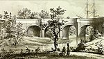 Upload another image |
| Gartnavel Royal Hospital | 1055 Great Western Road | 15 December 1970 | NS5503068034 | 55°53′01″N 4°19′09″W / 55.883567°N 4.319213°W / 55.883567; -4.319213 (Gartnavel Royal Hospital) | 1841-3, Charles Wilson. | 32318 |  Upload another image |
| St Mungo’s Academy Centenary Club [de] | 998 Great Western Road | 15 December 1970 | NS5593868004 | 55°53′01″N 4°18′17″W / 55.883571°N 4.304694°W / 55.883571; -4.304694 (St Mungo’s Academy Centenary Club [de]) | 1877, James Boucher. | 32334 | ![St Mungo’s Academy Centenary Club [de]](http://upload.wikimedia.org/wikipedia/commons/thumb/b/bf/St_Mungos_Academy_Centenary_Club.jpg/150px-St_Mungos_Academy_Centenary_Club.jpg) Upload another image |
| 11 Whittinghame Drive [de] | 5 September 1979 | NS5529068166 | 55°53′05″N 4°18′54″W / 55.884831°N 4.315131°W / 55.884831; -4.315131 (11 Whittinghame Drive [de]) | John Ednie, 1907. | 32342 | ![11 Whittinghame Drive [de]](http://upload.wikimedia.org/wikipedia/commons/thumb/4/4b/11_Whittinghame_Drive.jpg/150px-11_Whittinghame_Drive.jpg) Upload another image | |
| Ruchill Church Hall | 17 Shakespeare Street | 15 December 1970 | NS5725668308 | 55°53′12″N 4°17′02″W / 55.886692°N 4.283802°W / 55.886692; -4.283802 (Ruchill Church Hall) | Charles Rennie Mackintosh, 1899. | 32356 | 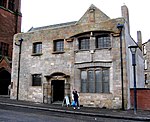 Upload another image |
| Queen's Park Church and Hall [de] | 20 Balvicar Drive, Balvicar Street, Camphill | 15 December 1970 | NS5786562432 | 55°50′03″N 4°16′16″W / 55.834119°N 4.270993°W / 55.834119; -4.270993 (Queen's Park Church and Hall [de]) | William Leiper, 1875-8. | 32359 | ![Queen's Park Church and Hall [de]](http://upload.wikimedia.org/wikipedia/commons/thumb/f/ff/Queen%27s_Park_Baptist_Church%2C_Glasgow%2C_Scotland.jpg/71px-Queen%27s_Park_Baptist_Church%2C_Glasgow%2C_Scotland.jpg) Upload another image |
| Langside Hall [de] | 1 Langside Avenue | 15 December 1970 | NS5744562150 | 55°49′53″N 4°16′39″W / 55.831463°N 4.277545°W / 55.831463; -4.277545 (Langside Hall [de]) | John Gibson (of Gibson and MacDougall) 1847-9 as National Bank of Scotland, Queen Street; re-erected without significant change on this site 1901; A B MacDonald City Engineer, assistant in charge named Horne. | 32369 | ![Langside Hall [de]](http://upload.wikimedia.org/wikipedia/commons/thumb/0/0c/Langside_Hall%2C_Glasgow_-_geograph.org.uk_-_92256.jpg/150px-Langside_Hall%2C_Glasgow_-_geograph.org.uk_-_92256.jpg) Upload another image |
| 25, 25A Mansionhouse Road [de] | 15 December 1970 | NS5759161495 | 55°49′32″N 4°16′30″W / 55.825626°N 4.274872°W / 55.825626; -4.274872 (25, 25A Mansionhouse Road [de]) | Alexander Thomson, 1856-7. | 32373 | ![25, 25A Mansionhouse Road [de]](http://upload.wikimedia.org/wikipedia/commons/thumb/b/b9/25_Mansionhouse_Road%2C_Glasgow%2C_Scotland.jpg/150px-25_Mansionhouse_Road%2C_Glasgow%2C_Scotland.jpg) Upload another image | |
| 2, 2A-38 (Even Nos) Millbrae Crescent | 15 December 1970 | NS5752161115 | 55°49′20″N 4°16′33″W / 55.822194°N 4.27579°W / 55.822194; -4.27579 (2, 2A-38 (Even Nos) Millbrae Crescent) | 1876-7 in style of Robert Turnbull. | 32384 |  Upload another image | |
| 1-10 (Inclusive Nos) Moray Place [de] Including 81 Nithsdale Road | 6 July 1966 | NS5771962789 | 55°50′14″N 4°16′25″W / 55.837281°N 4.273509°W / 55.837281; -4.273509 (1-10 (Inclusive Nos) Moray Place [de] Including 81 Nithsdale Road) | Built 1859-60, design perhaps 1857, by Alexander Thomson. Thomson himself resided at No 1. | 32386 | ![1-10 (Inclusive Nos) Moray Place [de] Including 81 Nithsdale Road](http://upload.wikimedia.org/wikipedia/commons/thumb/1/15/Moray_Place_Glasgow.jpg/150px-Moray_Place_Glasgow.jpg) Upload another image | |
| Camphill House [de] | 799 Pollokshaws Road | 15 December 1970 | NS5759762225 | 55°49′56″N 4°16′31″W / 55.832181°N 4.27516°W / 55.832181; -4.27516 (Camphill House [de]) | Possibly David Hamilton as architect. Built for Robert Thomson, cotton manufacturer, probably circa 1798. | 32401 | ![Camphill House [de]](http://upload.wikimedia.org/wikipedia/commons/thumb/2/22/799_Pollokshaws_Road%2C_Queen%27s_Park%2C_Camphill_House_01.jpg/150px-799_Pollokshaws_Road%2C_Queen%27s_Park%2C_Camphill_House_01.jpg) Upload another image |
| 265-289 (Odd Nos) Allison Street [de], 19, 21, 23 Garturk Street and 34 Daisy Street | 15 December 1970 | NS5863262593 | 55°50′09″N 4°15′32″W / 55.83579°N 4.258841°W / 55.83579; -4.258841 (265-289 (Odd Nos) Allison Street [de], 19, 21, 23 Garturk Street and 34 Daisy Street) | Alexander Thomson (d 1875), 1875-7, and presumably completed by his partner, Robert Turnbull, in Thomson's own style. | 32423 | ![265-289 (Odd Nos) Allison Street [de], 19, 21, 23 Garturk Street and 34 Daisy Street](http://upload.wikimedia.org/wikipedia/commons/thumb/6/65/265-289_Allison_Street%2C_Glasgow%2C_Scotland.jpg/150px-265-289_Allison_Street%2C_Glasgow%2C_Scotland.jpg) Upload another image | |
| Former Crosshill Queen's Park Church | 40 Queen's Drive | 15 December 1970 | NS5846562186 | 55°49′56″N 4°15′41″W / 55.832087°N 4.261293°W / 55.832087; -4.261293 (Former Crosshill Queen's Park Church) | Campbell Douglas and Sellars, 1872-3. | 32451 |  Upload another image |
| Kelvinside Academy | 20 Bellshaugh Road | 6 July 1966 | NS5655667906 | 55°52′58″N 4°17′41″W / 55.882875°N 4.294771°W / 55.882875; -4.294771 (Kelvinside Academy) | James Sellars, architect; 1877-9. | 32476 |  Upload another image |
| 15 Cleveden Gardens [de] | 15 December 1970 | NS5625768120 | 55°53′05″N 4°17′59″W / 55.884707°N 4.29966°W / 55.884707; -4.29966 (15 Cleveden Gardens [de]) | 1904, A N Prentice. | 32486 | ![15 Cleveden Gardens [de]](http://upload.wikimedia.org/wikipedia/commons/thumb/f/f9/15_Cleveden_Gardens.jpg/150px-15_Cleveden_Gardens.jpg) Upload another image | |
| 3-10 (Inclusive Nos) Crown Circus [de] and 1, 1A and 2 Crown Terrace and 15 and 17 Crown Road North | 15 December 1970 | NS5616067157 | 55°52′34″N 4°18′03″W / 55.876033°N 4.300698°W / 55.876033; -4.300698 (3-10 (Inclusive Nos) Crown Circus [de] and 1, 1A and 2 Crown Terrace and 15 and 17 Crown Road North) | James Thompson, 1858. | 32489 | ![3-10 (Inclusive Nos) Crown Circus [de] and 1, 1A and 2 Crown Terrace and 15 and 17 Crown Road North](http://upload.wikimedia.org/wikipedia/commons/thumb/f/fc/Crown_Crescent%2C_Glasgow.jpg/150px-Crown_Crescent%2C_Glasgow.jpg) Upload another image | |
| Kibble Palace | Botanic Gardens, 730 Great Western Road | 15 December 1970 | NS5693867446 | 55°52′44″N 4°17′18″W / 55.878859°N 4.288426°W / 55.878859; -4.288426 (Kibble Palace) | John Kibble, engineer. Originally erected 1863-6 at Coulport, Loch Long; removed here and enlarged 1873. | 32513 | 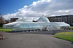 Upload another image |
| 1-11 (Inclusive Nos) Great Western Terrace [de], 2-34 (Even Nos) Great Western Terrace Lane, 1 and 1B Westbourne Gardens and 19 Westbourne Gardens | Great Western Road | 15 December 1970 | NS5621067704 | 55°52′51″N 4°18′01″W / 55.880959°N 4.30019°W / 55.880959; -4.30019 (1-11 (Inclusive Nos) Great Western Terrace [de], 2-34 (Even Nos) Great Western Terrace Lane, 1 and 1B Westbourne Gardens and 19 Westbourne Gardens) | 1869, Alexander Thomson. | 32517 | ![1-11 (Inclusive Nos) Great Western Terrace [de], 2-34 (Even Nos) Great Western Terrace Lane, 1 and 1B Westbourne Gardens and 19 Westbourne Gardens](http://upload.wikimedia.org/wikipedia/commons/thumb/e/e8/2-10_Great_Western_Terrace_-_general_view.jpg/100px-2-10_Great_Western_Terrace_-_general_view.jpg) Upload another image |
| 1-17 (Inclusive Nos) Grosvenor Terrace [de] | Great Western Road | 6 July 1966 | NS5670967376 | 55°52′41″N 4°17′31″W / 55.878163°N 4.292047°W / 55.878163; -4.292047 (1-17 (Inclusive Nos) Grosvenor Terrace [de]) | J T Rochead, 1855. Eastern half of terrace gutted by fire in 1978, rebuilt 1980. | 32520 | ![1-17 (Inclusive Nos) Grosvenor Terrace [de]](http://upload.wikimedia.org/wikipedia/commons/thumb/6/6e/1-17_%28Inclusive_Nos%29_Grosvenor_Terrace.jpg/150px-1-17_%28Inclusive_Nos%29_Grosvenor_Terrace.jpg) Upload another image |
| 21-39 (Odd Nos) Hyndland Road [de] | 6 July 1966 | NS5599367796 | 55°52′54″N 4°18′13″W / 55.88172°N 4.303705°W / 55.88172; -4.303705 (21-39 (Odd Nos) Hyndland Road [de]) | 1871, Alexander Thomson. | 32530 | ![21-39 (Odd Nos) Hyndland Road [de]](http://upload.wikimedia.org/wikipedia/commons/thumb/7/7b/21-39_%28Odd_Nos%29_Hyndland_Road.jpg/150px-21-39_%28Odd_Nos%29_Hyndland_Road.jpg) Upload another image | |
| Hyndland Parish Church, Church of Scotland | 79 Hyndland Road | 15 December 1970 | NS5588167507 | 55°52′45″N 4°18′19″W / 55.879092°N 4.30534°W / 55.879092; -4.30534 (Hyndland Parish Church, Church of Scotland) | William Leiper, 1886. | 32532 |  Upload another image |
| 3 Kirklee Road [de] and 1 Redlands Road | 15 December 1970 | NS5639767727 | 55°52′52″N 4°17′50″W / 55.881221°N 4.297216°W / 55.881221; -4.297216 (3 Kirklee Road [de] and 1 Redlands Road) | John A Campbell, circa 1902. | 32550 | ![3 Kirklee Road [de] and 1 Redlands Road](http://upload.wikimedia.org/wikipedia/commons/thumb/7/74/3_Kirklee_Road_and_1_Redlands_Road.jpg/150px-3_Kirklee_Road_and_1_Redlands_Road.jpg) Upload another image | |
| 7-23 (Odd Nos) Kirklee Road [de] and 2 Redlands Road | 15 December 1970 | NS5644067786 | 55°52′54″N 4°17′48″W / 55.881763°N 4.29656°W / 55.881763; -4.29656 (7-23 (Odd Nos) Kirklee Road [de] and 2 Redlands Road) | John A Campbell, 1900. | 32551 | ![7-23 (Odd Nos) Kirklee Road [de] and 2 Redlands Road](http://upload.wikimedia.org/wikipedia/commons/thumb/4/49/7-23_%28Odd_Nos%29_Kirklee_Road_and_2_Redlands_Road.jpg/150px-7-23_%28Odd_Nos%29_Kirklee_Road_and_2_Redlands_Road.jpg) Upload another image | |
| 1-14 (Inclusive Nos) Kirklee Terrace [de], and 1-14 Kirklee Terrace Lane (Inclusive Numbers) | Great Western Road | 6 July 1966 | NS5657567630 | 55°52′49″N 4°17′40″W / 55.880403°N 4.294321°W / 55.880403; -4.294321 (1-14 (Inclusive Nos) Kirklee Terrace [de], and 1-14 Kirklee Terrace Lane (Inclusive Numbers)) | 1845, Charles Wilson. | 32553 | ![1-14 (Inclusive Nos) Kirklee Terrace [de], and 1-14 Kirklee Terrace Lane (Inclusive Numbers)](http://upload.wikimedia.org/wikipedia/commons/thumb/8/81/1-14_%28Inclusive_Nos%29_Kirklee_Terrace.jpg/150px-1-14_%28Inclusive_Nos%29_Kirklee_Terrace.jpg) Upload another image |
| 9 Lowther Terrace [de] | Great Western Road | 15 December 1970 | NS5630067744 | 55°52′53″N 4°17′56″W / 55.881345°N 4.298774°W / 55.881345; -4.298774 (9 Lowther Terrace [de]) | Sydney Mitchell, 1904-6. | 32563 | ![9 Lowther Terrace [de]](http://upload.wikimedia.org/wikipedia/commons/thumb/4/43/9_Lowther_Terrace-2.jpg/112px-9_Lowther_Terrace-2.jpg) Upload another image |
| 10 Lowther Terrace [de] | Great Western Road | 15 December 1970 | NS5628867750 | 55°52′53″N 4°17′56″W / 55.881395°N 4.298969°W / 55.881395; -4.298969 (10 Lowther Terrace [de]) | James Miller, 1904. | 32564 | ![10 Lowther Terrace [de]](http://upload.wikimedia.org/wikipedia/commons/thumb/f/fa/10_Lowther_Terrace.jpg/112px-10_Lowther_Terrace.jpg) Upload another image |
| Notre Dame High School | 160 Observatory Road | 28 July 1987 | NS5626667407 | 55°52′42″N 4°17′57″W / 55.878309°N 4.299138°W / 55.878309; -4.299138 (Notre Dame High School) | Thomas S Cordiner, designed 1939, resumed 1949 completed 1953. Damaged by fire, 2010 | 32571 |  Upload another image |
| 1 Princes Terrace [de] | Prince Albert Road | 15 December 1970 | NS5616267256 | 55°52′37″N 4°18′03″W / 55.876922°N 4.300719°W / 55.876922; -4.300719 (1 Princes Terrace [de]) | James Thomson, circa 1870. | 32576 | ![1 Princes Terrace [de]](http://upload.wikimedia.org/wikipedia/commons/thumb/7/7f/1_Princes_Terrace%2C_Glasgow.jpg/150px-1_Princes_Terrace%2C_Glasgow.jpg) Upload another image |
| Kelvinside Hillhead Parish Church, Glasgow | 23 Saltoun Street | 15 December 1970 | NS5662967303 | 55°52′39″N 4°17′36″W / 55.877483°N 4.293286°W / 55.877483; -4.293286 (Kelvinside Hillhead Parish Church, Glasgow) | James Sellars, 1875-6.Church of Scotland. Formerly Belmont and Hillhead Parish Church. | 32584 |  Upload another image |
| Belhaven-Westbourne Church [de] and Hall, Church of Scotland | 52 Westbourne Gardens | 15 December 1970 | NS5602167768 | 55°52′53″N 4°18′12″W / 55.881477°N 4.303243°W / 55.881477; -4.303243 (Belhaven-Westbourne Church [de] and Hall, Church of Scotland) | 1881, John Honeyman. | 32605 | ![Belhaven-Westbourne Church [de] and Hall, Church of Scotland](http://upload.wikimedia.org/wikipedia/commons/thumb/4/4a/Belhaven-Westbourne_Church_and_Hall%2C_Church_of_Scotland.jpg/150px-Belhaven-Westbourne_Church_and_Hall%2C_Church_of_Scotland.jpg) Upload another image |
| 145-195 (Odd Nos) Albion Street [de] | 3 September 1974 | NS5965565265 | 55°51′36″N 4°14′38″W / 55.860078°N 4.243903°W / 55.860078; -4.243903 (145-195 (Odd Nos) Albion Street [de]) | Sir Owen Williams, 1936; 1986 alterations and large additions. Roof top addition by Frank Burnet, Bell and Partners, 1986-1988. | 32607 | ![145-195 (Odd Nos) Albion Street [de]](http://upload.wikimedia.org/wikipedia/commons/thumb/5/5d/The_Herald_Building%2C_145-195_%28Odd_Nos%29_Albion_Street%2C_Glasgow%2C_2018-06-28_angle.jpg/150px-The_Herald_Building%2C_145-195_%28Odd_Nos%29_Albion_Street%2C_Glasgow%2C_2018-06-28_angle.jpg) Upload another image | |
| Buck's Head Buildings [de] | 63 Argyle Street | 15 December 1970 | NS5918565002 | 55°51′27″N 4°15′05″W / 55.857579°N 4.251269°W / 55.857579; -4.251269 (Buck's Head Buildings [de]) | Alexander Thomson, 1863. | 32608 | ![Buck's Head Buildings [de]](http://upload.wikimedia.org/wikipedia/commons/thumb/5/50/Bucks_Head_Buildings_%28geograph_2746497%29.jpg/112px-Bucks_Head_Buildings_%28geograph_2746497%29.jpg) Upload another image |
| Argyle Street, Argyll Arcade [de] (Through 98-102 Argyle Street) 3-66 (Inclusive Nos, Leading to Buchanan Street) | Argyle Street | 15 December 1970 | NS5906065089 | 55°51′30″N 4°15′12″W / 55.858324°N 4.25331°W / 55.858324; -4.25331 (Argyle Street, Argyll Arcade [de] (Through 98-102 Argyle Street) 3-66 (Inclusive Nos, Leading to Buchanan Street)) | John Baird I, 1827. | 32613 | ![Argyle Street, Argyll Arcade [de] (Through 98-102 Argyle Street) 3-66 (Inclusive Nos, Leading to Buchanan Street)](http://upload.wikimedia.org/wikipedia/commons/thumb/a/a1/Argyle_Arcade_-_geograph.org.uk_-_110486.jpg/150px-Argyle_Arcade_-_geograph.org.uk_-_110486.jpg) Upload another image |
| David Sloan's Arcade Cafe | 62 Argyll Arcade/108 Argyle Street, Morrison Court | 15 December 1970 | NS5903665113 | 55°51′31″N 4°15′13″W / 55.858532°N 4.253705°W / 55.858532; -4.253705 (David Sloan's Arcade Cafe) | Possibly by John Baird 1827-8; interior remodelled by Charles H Robinson 1900. | 32614 |  Upload another image |
| Martyrs' Public School | 17 Parson Street. | 15 December 1970 | NS6008165839 | 55°51′55″N 4°14′15″W / 55.865355°N 4.237399°W / 55.865355; -4.237399 (Martyrs' Public School) | Charles Rennie Mackintosh (of John Honeyman and Keppie), 1895-1898. | 32619 |  Upload another image |
| 60-62 (Even Nos) Buchanan Street [de] | Buchanan Street | 15 December 1970 | NS5901965226 | 55°51′34″N 4°15′15″W / 55.859542°N 4.254035°W / 55.859542; -4.254035 (60-62 (Even Nos) Buchanan Street [de]) | Robert Thomson (with Andrew Wilson assisting), 1894-96. | 32635 | ![60-62 (Even Nos) Buchanan Street [de]](http://upload.wikimedia.org/wikipedia/commons/thumb/f/f0/60-62_Buchanan_Street%2C_Glasgow.jpg/84px-60-62_Buchanan_Street%2C_Glasgow.jpg) Upload another image |
| 92-100 (Even Nos) Buchanan Street [de], known as 98 Buchanan Street | Buchanan Street | 15 December 1970 | NS5903365310 | 55°51′37″N 4°15′14″W / 55.8603°N 4.253856°W / 55.8603; -4.253856 (92-100 (Even Nos) Buchanan Street [de], known as 98 Buchanan Street) | Charles Wilson, 1850-51. | 32639 | ![92-100 (Even Nos) Buchanan Street [de], known as 98 Buchanan Street](http://upload.wikimedia.org/wikipedia/commons/thumb/9/97/98_Buchanan_Street%2C_Glasgow.jpg/150px-98_Buchanan_Street%2C_Glasgow.jpg) Upload another image |
| Britannia Buildings [de] | 164A-168 (Even Nos) Buchanan Street with 10 Dundas Lane | 15 December 1970 | NS5909765542 | 55°51′45″N 4°15′11″W / 55.862402°N 4.252954°W / 55.862402; -4.252954 (Britannia Buildings [de]) | John A Campbell, 1898. | 32643 | ![Britannia Buildings [de]](http://upload.wikimedia.org/wikipedia/commons/thumb/e/e9/Britannia_Buildings.jpg/112px-Britannia_Buildings.jpg) Upload another image |
| Glasgow City Halls | Candleriggs, Merchant City | 15 December 1970 | NS5957165145 | 55°51′32″N 4°14′43″W / 55.858976°N 4.245182°W / 55.858976; -4.245182 (Glasgow City Halls) | Main hall facade to Candleriggs John Carrick, 1885. Complex site with multiple architects over time.[12] | 32647 |  Upload another image |
| Provand's Lordship | 3 Castle Street | 6 July 1966 | NS6009665506 | 55°51′45″N 4°14′13″W / 55.86237°N 4.236987°W / 55.86237; -4.236987 (Provand's Lordship) | 1471 with extensions to the West of 1670. | 32648 |  Upload another image |
| Bridge of Sighs and Superintendent's House [de] | Cathedral Square | 15 December 1970 | NS6018265506 | 55°51′45″N 4°14′08″W / 55.862395°N 4.235614°W / 55.862395; -4.235614 (Bridge of Sighs and Superintendent's House [de]) | David and James Hamilton architects, 1833-40. Includes gates and gatepiers by David Hamilton, 1838, ironwork of gates by T Edington. | 32651 | ![Bridge of Sighs and Superintendent's House [de]](http://upload.wikimedia.org/wikipedia/commons/thumb/2/2a/Glasgow_Necropolis_003.jpg/150px-Glasgow_Necropolis_003.jpg) Upload another image |
| Glasgow Evangelical Church [de]; (Former Barony North Church), and Church House | 20 Cathedral Square, 14 Cathedral Square | 15 December 1970 | NS6021265399 | 55°51′41″N 4°14′06″W / 55.861443°N 4.23508°W / 55.861443; -4.23508 (Glasgow Evangelical Church [de]; (Former Barony North Church), and Church House) | John Honeyman, 1878. | 32652 | ![Glasgow Evangelical Church [de]; (Former Barony North Church), and Church House](http://upload.wikimedia.org/wikipedia/commons/thumb/8/87/Glasgow%2C_Glasgow_Evangelical_Church_-_geograph.org.uk_-_1535218.jpg/112px-Glasgow%2C_Glasgow_Evangelical_Church_-_geograph.org.uk_-_1535218.jpg) Upload another image |
| Glasgow Cathedral and Cathedral Graveyard | 70 Cathedral Square | 15 December 1970 | NS6025565657 | 55°51′50″N 4°14′04″W / 55.863771°N 4.234527°W / 55.863771; -4.234527 (Glasgow Cathedral and Cathedral Graveyard) | A new cathedral to serve the diocese of Glasgow was begun circa 1118 and consecrated in 1136. Further works in the 1180s prior to its second consecration in 1197. Subsequent campaigns of work include the Blackadder aisle completed between 1483 and 1508.[13] | 32654 |  Upload another image |
| Statue of William III | Cathedral Square | 6 July 1966 | NS6013565441 | 55°51′42″N 4°14′11″W / 55.861797°N 4.236331°W / 55.861797; -4.236331 (Statue of William III) | Presented 1835 by Governor Macrae of Madras. Equestrian bronze of William III (as Emperor Constantine), sculptor unknown. | 32660 |  Upload another image |
| Former Our Lady and St Francis Secondary School [de] | 72 Charlotte Street | 4 September 1989 | NS5979364539 | 55°51′13″N 4°14′29″W / 55.8536°N 4.241324°W / 55.8536; -4.241324 (Former Our Lady and St Francis Secondary School [de]) | Jack Coia of Gillespie, Kidd & Coia, 1963. | 32662 | ![Former Our Lady and St Francis Secondary School [de]](http://upload.wikimedia.org/wikipedia/commons/thumb/0/0a/Former_Our_Lady_%26_St_Francis_Secondary_School_%28geograph_4254514%29.jpg/150px-Former_Our_Lady_%26_St_Francis_Secondary_School_%28geograph_4254514%29.jpg) Upload another image |
| 52 Charlotte Street [de] | 15 December 1970 | NS5983264628 | 55°51′16″N 4°14′27″W / 55.85441°N 4.240748°W / 55.85441; -4.240748 (52 Charlotte Street [de]) | Built circa 1790, school of Robert Adam. | 32663 | ![52 Charlotte Street [de]](http://upload.wikimedia.org/wikipedia/commons/thumb/a/a3/52_Charlotte_Street%2C_Glasgow._2018-06-27.jpg/150px-52_Charlotte_Street%2C_Glasgow._2018-06-27.jpg) Upload another image | |
| Old Fish Market known as the Briggait | 72 Clyde Street and 135 Bridgegate | 15 October 1970 | NS5928264640 | 55°51′16″N 4°14′58″W / 55.854358°N 4.249533°W / 55.854358; -4.249533 (Old Fish Market known as the Briggait) | Clarke and Bell, 1873. | 32664 |  Upload another image |
| Merchants Steeple, now enclosed within The Briggait | 72 Clyde Street, Bridgegate | 6 July 1966 | NS5930564671 | 55°51′17″N 4°14′57″W / 55.854643°N 4.249182°W / 55.854643; -4.249182 (Merchants Steeple, now enclosed within The Briggait) | Completed 1665. | 32665 |  Upload another image |
| St Andrew's Roman Catholic Cathedral | 168 Clyde Street and Fox Lane | 15 December 1970 | NS5908064792 | 55°51′20″N 4°15′10″W / 55.855663°N 4.252836°W / 55.855663; -4.252836 (St Andrew's Roman Catholic Cathedral) | J Gillespie Graham, 1814-17. | 32666 |  Upload another image |
| Albert Bridge | Clyde Street | 22 March 1977 | NS5941264443 | 55°51′09″N 4°14′50″W / 55.852627°N 4.247356°W / 55.852627; -4.247356 (Albert Bridge) | Bell and Miller, architects and engineers, Hanna, Donald and Wilson contractors; 1868-1871. | 32667 |  Upload another image |
| South Portland Street Suspension Bridge | Clyde Street and South Portland Street | 6 July 1966 | NS5890764722 | 55°51′18″N 4°15′20″W / 55.854984°N 4.255561°W / 55.854984; -4.255561 (South Portland Street Suspension Bridge) | Alexander Kirkland, architect. George Martin, engineer. 1851-3. | 32668 | 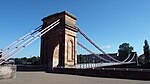 Upload another image |
| Victoria Bridge | Clyde Street | 15 December 1970 | NS5917364578 | 55°51′14″N 4°15′04″W / 55.853769°N 4.25124°W / 55.853769; -4.25124 (Victoria Bridge) | James Walker, engineer; 1851-1854. | 32669 |  Upload another image |
| Formerly the John Street Church [de] | 29 Cochrane Street and 18 John Street | 15 December 1970 | NS5943665275 | 55°51′36″N 4°14′51″W / 55.860104°N 4.247404°W / 55.860104; -4.247404 (Formerly the John Street Church [de]) | J T Rochead, 1859. | 32672 | ![Formerly the John Street Church [de]](http://upload.wikimedia.org/wikipedia/commons/thumb/b/b4/29_Cochrane_Street_and_18_John_Street_formerly_the_John_Street_Church%2C_2018-06-30_60deg.jpg/150px-29_Cochrane_Street_and_18_John_Street_formerly_the_John_Street_Church%2C_2018-06-30_60deg.jpg) Upload another image |
| Extension to the City Chambers | 20-40 (Even Nos) Cochrane Street, 20 John Street and 233-235 (Odd Nos) George Street | 15 December 1970 | NS5943465380 | 55°51′40″N 4°14′51″W / 55.861046°N 4.24749°W / 55.861046; -4.24749 (Extension to the City Chambers) | Watson Salmond and Gray, 1913-1929. | 32675 |  Upload another image |
| Former General Post Office [de] | George Square | 15 December 1970 | NS5928265311 | 55°51′37″N 4°15′00″W / 55.860382°N 4.249881°W / 55.860382; -4.249881 (Former General Post Office [de]) | Original building Robert Mathieson, architect H M Office of Public Works for Scotland, 1875-8. Rear elevation to Ingram Street remodelled by W W Robertson in 1892-4. Side elevations enclosing Robertson's work, by W T Oldrieve and C J W Simpson, 1914-16. | 32685 | ![Former General Post Office [de]](http://upload.wikimedia.org/wikipedia/commons/thumb/f/fb/Former_General_Post_Office.jpg/150px-Former_General_Post_Office.jpg) Upload another image |
| 24 George Square [de] and 12-16 (Even Nos) Anchor Lane | George Square | 15 December 1970 | NS5916465420 | 55°51′41″N 4°15′07″W / 55.861326°N 4.251821°W / 55.861326; -4.251821 (24 George Square [de] and 12-16 (Even Nos) Anchor Lane) | James Sellars, 1874. | 32688 | ![24 George Square [de] and 12-16 (Even Nos) Anchor Lane](http://upload.wikimedia.org/wikipedia/commons/thumb/c/c9/24_George_Square%2C_Glasgow%2C_2018-06-27.jpg/110px-24_George_Square%2C_Glasgow%2C_2018-06-27.jpg) Upload another image |
| The Merchants' House [de] | 30 George Square and 7 West George Street | 15 December 1970 | NS5916965440 | 55°51′41″N 4°15′06″W / 55.861507°N 4.251752°W / 55.861507; -4.251752 (The Merchants' House [de]) | John Burnet, 1874-8, 3-storey and basement office building, raised by J J Burnet 1907-8, by 2 storeys and an attic. Sculpture by Young. | 32689 | ![The Merchants' House [de]](http://upload.wikimedia.org/wikipedia/commons/thumb/b/b7/The_Merchants_House_%28geograph_4685698%29.jpg/122px-The_Merchants_House_%28geograph_4685698%29.jpg) Upload another image |
| Glasgow City Chambers | 80 George Square | 15 December 1970 | NS5936065375 | 55°51′40″N 4°14′55″W / 55.860979°N 4.248669°W / 55.860979; -4.248669 (Glasgow City Chambers) | William Young, architect, 1882-1888, interior 1887-1890. Contractors, Morrison and Mason. Sculpture by John Mossman and George Lawson. | 32691 |  Upload another image |
| Walter Scott Memorial Column [de] | George Square | 6 July 1966 | NS5926665396 | 55°51′40″N 4°15′01″W / 55.86114°N 4.250181°W / 55.86114; -4.250181 (Walter Scott Memorial Column [de]) | Column and base by David Rhind, 1837. Statue designed by John Greenshields, executed by A Handyside Ritchie. | 32696 | ![Walter Scott Memorial Column [de]](http://upload.wikimedia.org/wikipedia/commons/thumb/9/9a/Walter_Scott_statue%2C_Glasgow.JPG/101px-Walter_Scott_statue%2C_Glasgow.JPG) Upload another image |
| James Watt Statue [de] | George Square | 6 July 1966 | NS5920065384 | 55°51′40″N 4°15′04″W / 55.861013°N 4.251228°W / 55.861013; -4.251228 (James Watt Statue [de]) | Francis Chantrey, 1832. | 32697 | ![James Watt Statue [de]](http://upload.wikimedia.org/wikipedia/commons/thumb/c/c7/James_Watt_George_Square_-_geograph.org.uk_-_1267210.jpg/112px-James_Watt_George_Square_-_geograph.org.uk_-_1267210.jpg) Upload another image |
| Sir John Moore Statue [de] | George Square | 6 July 1966 | NS5931565357 | 55°51′39″N 4°14′58″W / 55.860804°N 4.249378°W / 55.860804; -4.249378 (Sir John Moore Statue [de]) | John Flaxman, 1819. | 32698 | ![Sir John Moore Statue [de]](http://upload.wikimedia.org/wikipedia/commons/thumb/9/99/JohnMooreGlasgow.jpg/75px-JohnMooreGlasgow.jpg) Upload another image |
| Equestrian statue of Albert, Prince Consort (Glasgow) [de] | George Square | 15 December 1970 | NS5920065384 | 55°51′40″N 4°15′04″W / 55.861013°N 4.251228°W / 55.861013; -4.251228 (Equestrian statue of Albert, Prince Consort (Glasgow) [de]) | Baron Carlo Marochetti, pre-1854. | 32701 | ![Equestrian statue of Albert, Prince Consort (Glasgow) [de]](http://upload.wikimedia.org/wikipedia/commons/thumb/e/ed/Glasgow_%2815741422759%29.jpg/150px-Glasgow_%2815741422759%29.jpg) Upload another image |
| Equestrian statue of Victoria (Glasgow) [de] | George Square | 15 December 1970 | NS5921465439 | 55°51′41″N 4°15′04″W / 55.861511°N 4.251033°W / 55.861511; -4.251033 (Equestrian statue of Victoria (Glasgow) [de]) | Baron Carlo Marochetti, pre-1854. | 32702 | ![Equestrian statue of Victoria (Glasgow) [de]](http://upload.wikimedia.org/wikipedia/commons/thumb/d/d6/VictoriaStatue.jpg/150px-VictoriaStatue.jpg) Upload another image |
| 266 George Street [de] | 9 March 1989 | NS5940565443 | 55°51′42″N 4°14′53″W / 55.861603°N 4.247986°W / 55.861603; -4.247986 (266 George Street [de]) | Thomson and Sandilands, 1900. | 32709 | ![266 George Street [de]](http://upload.wikimedia.org/wikipedia/commons/thumb/4/47/266_George_Street%2C_Glasgow%2C_2018-06-27.jpg/106px-266_George_Street%2C_Glasgow%2C_2018-06-27.jpg) Upload another image | |
| The Trades Hall of Glasgow [de] | 85 Glassford Street | 6 July 1966 | NS5932965183 | 55°51′33″N 4°14′57″W / 55.859246°N 4.249064°W / 55.859246; -4.249064 (The Trades Hall of Glasgow [de]) | Robert Adam, 1791-9, completed posthumously. David Hamilton extensions at rear 1838, interior recast by James Sellars in 1887-8 partially or totally refaced by John Keppie 1927; 1916 John Keppie redecorated the saloon. | 32713 | ![The Trades Hall of Glasgow [de]](http://upload.wikimedia.org/wikipedia/commons/thumb/a/a4/The_Trades_Hall_of_Glasgow.jpg/150px-The_Trades_Hall_of_Glasgow.jpg) Upload another image |
| Tolbooth Steeple | Glasgow Cross | 6 July 1966 | NS5965964900 | 55°51′24″N 4°14′37″W / 55.856802°N 4.24365°W / 55.856802; -4.24365 (Tolbooth Steeple) | Built 1626-1634 by John Boyd, architect and Master of Works. The Tolbooth was demolished in 1921. | 32717 | 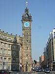 Upload another image |
| 177 Ingram Street with 99 Glassford Street [de] | 15 December 1970 | NS5933365224 | 55°51′35″N 4°14′56″W / 55.859616°N 4.249022°W / 55.859616; -4.249022 (177 Ingram Street with 99 Glassford Street [de]) | John Burnet, 1865-66. Sculpture by George Frampton. | 32734 | ![177 Ingram Street with 99 Glassford Street [de]](http://upload.wikimedia.org/wikipedia/commons/thumb/7/74/177_Ingram_Street_with_99_Glassford_Street.jpg/150px-177_Ingram_Street_with_99_Glassford_Street.jpg) Upload another image | |
| Lanarkshire House, Corinthian Club (Former Sheriff Court and Justice of Peace Court) | 191 Ingram Street | 15 December 1970 | NS5928965217 | 55°51′34″N 4°14′59″W / 55.85954°N 4.249721°W / 55.85954; -4.249721 (Lanarkshire House, Corinthian Club (Former Sheriff Court and Justice of Peace Court)) | David Hamilton in 1841 with alterations and additions including a telling room by James Salmon Sr in 1853. It was refronted and additions made by John Burnet Senior in 1876-9.[14] | 32735 |  Upload another image |
| Ramshorn Theatre | 98 Ingram Street | 15 December 1970 | NS5958565228 | 55°51′35″N 4°14′42″W / 55.859725°N 4.245001°W / 55.859725; -4.245001 (Ramshorn Theatre) | Thomas Rickman, 1824-1826; Page and Park, conversion to theatre c1990-92. Formerly St Paul's and St David's Church, Church of Scotland | 32740 |  Upload another image |
| Hutchesons' Hall | 158 Ingram Street, and 2 John Street | 6 November 1966 | NS5942265249 | 55°51′36″N 4°14′51″W / 55.859866°N 4.247614°W / 55.859866; -4.247614 (Hutchesons' Hall) | David Hamilton, 1802-1805, interior by John Baird II 1876. | 32744 |  Upload another image |
| 16 McPhater Street [de], and return elevation to Dunblane Street (Ozalid's) | 15 December 1970 | NS5897666080 | 55°52′02″N 4°15′19″W / 55.867196°N 4.255166°W / 55.867196; -4.255166 (16 McPhater Street [de], and return elevation to Dunblane Street (Ozalid's)) | William James Anderson, 1892-95. | 32754 | ![16 McPhater Street [de], and return elevation to Dunblane Street (Ozalid's)](http://upload.wikimedia.org/wikipedia/commons/thumb/b/bc/McPhater_Street_-_geograph.org.uk_-_995658.jpg/150px-McPhater_Street_-_geograph.org.uk_-_995658.jpg) Upload another image | |
| 61-63 (Odd Nos) Miller Street [de] | 15 December 1970 | NS5919065177 | 55°51′33″N 4°15′05″W / 55.859152°N 4.25128°W / 55.859152; -4.25128 (61-63 (Odd Nos) Miller Street [de]) | J Burnet Sr, 1854 with alterations by J Burnet and Son, 1900 and 1901. | 32758 | ![61-63 (Odd Nos) Miller Street [de]](http://upload.wikimedia.org/wikipedia/commons/thumb/e/e4/61-63_%28Odd_Nos%29_Miller_Street.jpg/150px-61-63_%28Odd_Nos%29_Miller_Street.jpg) Upload another image | |
| Arthur's Warehouse [de] | 77-81 (Odd Nos) Miller Street | 6 November 1966 | NS5920065207 | 55°51′34″N 4°15′04″W / 55.859424°N 4.251136°W / 55.859424; -4.251136 (Arthur's Warehouse [de]) | Robert Black and James Salmon Sr, 1849-50. | 32759 | ![Arthur's Warehouse [de]](http://upload.wikimedia.org/wikipedia/commons/thumb/7/7d/77-81_%28Odd_Nos%29_Miller_Street.jpg/150px-77-81_%28Odd_Nos%29_Miller_Street.jpg) Upload another image |
| 42 Miller Street [de] | 15 December 1970 | NS5921265125 | 55°51′31″N 4°15′03″W / 55.858692°N 4.250902°W / 55.858692; -4.250902 (42 Miller Street [de]) | John Craig, wright, 1775; restored by McGurn, Logan, Duncan & Opfer, 1994-5. | 32760 | ![42 Miller Street [de]](http://upload.wikimedia.org/wikipedia/commons/thumb/8/82/42_Miller_Street%2C_Baillie_Craig%27s_House.jpg/150px-42_Miller_Street%2C_Baillie_Craig%27s_House.jpg) Upload another image | |
| Formerly Stirling's Library [de] | 48-54 (Even Nos) Miller Street | 15 December 1970 | NS5921565142 | 55°51′32″N 4°15′03″W / 55.858845°N 4.250863°W / 55.858845; -4.250863 (Formerly Stirling's Library [de]) | James Smith, 1863-5, completed after his death by Melvin and Leiper. | 32761 | ![Formerly Stirling's Library [de]](http://upload.wikimedia.org/wikipedia/commons/thumb/c/c4/48-54_%28Even_Nos%29_Miller_Street.jpg/112px-48-54_%28Even_Nos%29_Miller_Street.jpg) Upload another image |
| Tron Steeple | 71 Trongate | 6 July 1966 | NS5954264916 | 55°51′25″N 4°14′44″W / 55.856911°N 4.245526°W / 55.856911; -4.245526 (Tron Steeple) | 1630-36. Tower pierced at ground by Tudor arches in 1855 by John Carrick. | 32769 |  Upload another image |
| Britannia Music Hall | 109-121 (Odd Nos) Trongate and 9 New Wynd | 22 March 1977 | NS5945264917 | 55°51′25″N 4°14′49″W / 55.856894°N 4.246963°W / 55.856894; -4.246963 (Britannia Music Hall) | Gildard & MacFarlane architects, dated 1857 on frieze; rear staircase, 1869, by Hugh Barclay; further alterations to cinema usage 1904-10 by Boswell & McIntyre. | 32774 |  Upload another image |
| 60-90 (Even Nos) Trongate [de] and 19-29 (Odd Nos) Albion Street | 15 December 1970 | NS5952964955 | 55°51′26″N 4°14′45″W / 55.857258°N 4.245754°W / 55.857258; -4.245754 (60-90 (Even Nos) Trongate [de] and 19-29 (Odd Nos) Albion Street) | J T Rochead, 1854. | 32782 | ![60-90 (Even Nos) Trongate [de] and 19-29 (Odd Nos) Albion Street](http://upload.wikimedia.org/wikipedia/commons/thumb/1/18/Merchant_City%2C_Glasgow_011.jpg/100px-Merchant_City%2C_Glasgow_011.jpg) Upload another image | |
| 190 Trongate [de] and 2-4 (Even Nos) Glassford Street | 15 December 1970 | NS5932664999 | 55°51′27″N 4°14′56″W / 55.857594°N 4.249017°W / 55.857594; -4.249017 (190 Trongate [de] and 2-4 (Even Nos) Glassford Street) | T P Marwick architect with W Birnie Rhind sculptor 1903. | 32789 | ![190 Trongate [de] and 2-4 (Even Nos) Glassford Street](http://upload.wikimedia.org/wikipedia/commons/thumb/8/81/Trongate_at_Glassford_Street_-_geograph.org.uk_-_975061.jpg/112px-Trongate_at_Glassford_Street_-_geograph.org.uk_-_975061.jpg) Upload another image | |
| St Andrew's-by-the-Green | 33 Turnbull Street | 6 July 1966 | NS5961964601 | 55°51′15″N 4°14′39″W / 55.854106°N 4.244134°W / 55.854106; -4.244134 (St Andrew's-by-the-Green) | Andrew Hunter and William Paull, joint master masons; Thomas Thomson, wright; built 1750-1. | 32790 |  Upload another image |
| 37-47 (Odd Nos) Virginia Street [de] | 15 December 1970 | NS5925965135 | 55°51′32″N 4°15′01″W / 55.858795°N 4.250157°W / 55.858795; -4.250157 (37-47 (Odd Nos) Virginia Street [de]) | Circa 1817. | 32795 | ![37-47 (Odd Nos) Virginia Street [de]](http://upload.wikimedia.org/wikipedia/commons/thumb/a/a6/37-47_%28Odd_Nos%29_Virginia_Street%2C_Glasgow%2C_2018-06-27.jpg/93px-37-47_%28Odd_Nos%29_Virginia_Street%2C_Glasgow%2C_2018-06-27.jpg) Upload another image | |
| 49-53 (Odd Nos) Virginia Street [de] | 15 December 1970 | NS5926165150 | 55°51′32″N 4°15′00″W / 55.85893°N 4.250133°W / 55.85893; -4.250133 (49-53 (Odd Nos) Virginia Street [de]) | Circa 1817. Designed in unison with Nos 37-49 Virginia Street, known as Virginia Buildings; surviving examples of commercial street architecture in the Merchant City.[15] | 32796 | ![49-53 (Odd Nos) Virginia Street [de]](http://upload.wikimedia.org/wikipedia/commons/thumb/a/af/49-53_%28Odd_Nos%29_Virginia_Street-2.jpg/112px-49-53_%28Odd_Nos%29_Virginia_Street-2.jpg) Upload another image | |
| 42 Virginia Street [de] | 15 December 1970 | NS5928465101 | 55°51′31″N 4°14′59″W / 55.858497°N 4.24974°W / 55.858497; -4.24974 (42 Virginia Street [de]) | R G Melvin and W Leiper, 1867. | 32798 | ![42 Virginia Street [de]](http://upload.wikimedia.org/wikipedia/commons/thumb/6/68/42_Virginia_Street%2C_Glasgow%2C_2018-06-27.jpg/150px-42_Virginia_Street%2C_Glasgow%2C_2018-06-27.jpg) Upload another image | |
| Tron Theatre | 38 Parnie Street | 15 December 1970 | NS5952664880 | 55°51′24″N 4°14′45″W / 55.856584°N 4.245763°W / 55.856584; -4.245763 (Tron Theatre) | James Adam, 1793-4. To the East wall a Baroque screen wall and gateway were added forming a courtyard, J J Burnet, 1899-1900. In 1981 the former Church was converted into a theatre by McGurn, Logan and Duncan. Former Tron Kirk | 32812 | 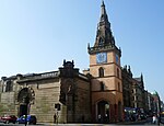 Upload another image |
| Gallery of Modern Art | 111 Queen Street and 46-58 (Even Nos) Royal Exchange Square | 6 July 1966 | NS5912565288 | 55°51′36″N 4°15′09″W / 55.860129°N 4.252375°W / 55.860129; -4.252375 (Gallery of Modern Art) | David Hamilton, 1827-30, with 2nd E attic by Hamilton, 1880. Sculpture by James Fillans. Former Stirling's Library, Former Cunninghame Mansion and Former Royal Exchange | 32818 |  Upload another image |
| St George’s Buildings [de] | 151-157 (Odd Nos) Queen Street | 6 July 1966 | NS5914265344 | 55°51′38″N 4°15′08″W / 55.860637°N 4.252133°W / 55.860637; -4.252133 (St George’s Buildings [de]) | David Hamilton, circa 1834. | 32819 | ![St George’s Buildings [de]](http://upload.wikimedia.org/wikipedia/commons/thumb/8/81/St_George%27s_Buildings.jpg/150px-St_George%27s_Buildings.jpg) Upload another image |
| Queen Street station | Cathedral Street | 15 December 1970 | NS5920765545 | 55°51′45″N 4°15′04″W / 55.862461°N 4.2512°W / 55.862461; -4.2512 (Queen Street station) | James Carswell, 1878-80, executed by P and W MacLellan. | 32822 |  Upload another image |
| Duke of Wellington Statue | Queen Street | 15 December 1970 | NS5914665283 | 55°51′36″N 4°15′07″W / 55.860091°N 4.252038°W / 55.860091; -4.252038 (Duke of Wellington Statue) | Baron Carlo Marochetti, 1844. | 32823 |  Upload another image |
| Barony Hall, University of Strathclyde | Cathedral Square | 6 July 1966 | NS6008665451 | 55°51′43″N 4°14′14″W / 55.861873°N 4.237119°W / 55.861873; -4.237119 (Barony Hall, University of Strathclyde) | Sir John James Burnet and John Archibald Campbell, 1886-90; David Leslie of Walter Underwood and Partners followed by David Leslie Partnership restored with additions, 1986-95. Former Barony Church and Church Hall. Listing includes War Memorial, retaining wall, railings and gatepiers | 32824 |  Upload another image |
| 1-29 (Odd Nos) and 2-40 (Even Nos) Royal Exchange Square [de] with 145-147 (Odd Nos) Queen Street and Archways | 15 December 1970 | NS5913965323 | 55°51′38″N 4°15′08″W / 55.860448°N 4.25217°W / 55.860448; -4.25217 (1-29 (Odd Nos) and 2-40 (Even Nos) Royal Exchange Square [de] with 145-147 (Odd Nos) Queen Street and Archways) | Nos 1-29 at S, David Hamilton and Robert Black, 1830, and Nos 2-40 at N, Hamilton and James Smith, based on scheme by Archibald Elliot II. | 32826 | ![1-29 (Odd Nos) and 2-40 (Even Nos) Royal Exchange Square [de] with 145-147 (Odd Nos) Queen Street and Archways](http://upload.wikimedia.org/wikipedia/commons/thumb/8/8e/Royal_Exchange_Square.jpg/150px-Royal_Exchange_Square.jpg) Upload another image | |
| Royal Bank of Scotland (Glasgow) [de] | Royal Exchange Square | 6 July 1966 | NS5905365305 | 55°51′37″N 4°15′13″W / 55.860261°N 4.253534°W / 55.860261; -4.253534 (Royal Bank of Scotland (Glasgow) [de]) | Archibald Elliot, 1827. | 32827 | ![Royal Bank of Scotland (Glasgow) [de]](http://upload.wikimedia.org/wikipedia/commons/thumb/3/39/Royal_Bank_of_Scotland_2013-09-17_12-32-00.jpg/150px-Royal_Bank_of_Scotland_2013-09-17_12-32-00.jpg) Upload another image |
| Blochairn Parish Church (Church of Scotland) [de] | 178 Roystonhill, Royston | 3 September 1974 | NS6072166112 | 55°52′05″N 4°13′38″W / 55.867991°N 4.227321°W / 55.867991; -4.227321 (Blochairn Parish Church (Church of Scotland) [de]) | Campbell Douglas and Stevenson, architects, 1865-6, interior and stained glass by Morris and Co. | 32828 | ![Blochairn Parish Church (Church of Scotland) [de]](http://upload.wikimedia.org/wikipedia/commons/thumb/7/75/Roystonhill_Spire_-_geograph.org.uk_-_691535.jpg/112px-Roystonhill_Spire_-_geograph.org.uk_-_691535.jpg) Upload another image |
| St Andrew's in the Square | St Andrews Square | 6 July 1966 | NS5970264677 | 55°51′17″N 4°14′34″W / 55.854812°N 4.242848°W / 55.854812; -4.242848 (St Andrew's in the Square) | Alan Dreghorn, 1739-1756. Gibbsesque Palladian modelled after St Martin-in-the-Fields.[16] | 32830 |  Upload another image |
| St Enoch Square Travel Centre | St Enoch Square | 15 December 1970 | NS5893765003 | 55°51′27″N 4°15′19″W / 55.857516°N 4.255228°W / 55.857516; -4.255228 (St Enoch Square Travel Centre) | James Miller, 1896. Formerly St Enoch Underground Station. | 32833 |  Upload another image |
| Scottish Provident Institution [de] | 17-29 (Odd Nos) St Vincent Place | 15 December 1970 | NS5910365359 | 55°51′39″N 4°15′10″W / 55.86076°N 4.252764°W / 55.86076; -4.252764 (Scottish Provident Institution [de]) | J M Dick Peddie, 1904-8. | 32836 | ![Scottish Provident Institution [de]](http://upload.wikimedia.org/wikipedia/commons/thumb/e/eb/27a%2C_29_St_Vincent_Place%2C_Public_House.jpg/84px-27a%2C_29_St_Vincent_Place%2C_Public_House.jpg) Upload another image |
| 2 St Vincent Place [de] and 2 and 4 Anchor Lane | 6 July 1966 | NS5915865407 | 55°51′40″N 4°15′07″W / 55.861208°N 4.251911°W / 55.861208; -4.251911 (2 St Vincent Place [de] and 2 and 4 Anchor Lane) | J T Rochead, 1867-70. Sculpture by William Mossman. | 32838 | ![2 St Vincent Place [de] and 2 and 4 Anchor Lane](http://upload.wikimedia.org/wikipedia/commons/thumb/b/b0/2_St_Vincent_Place_and_2_and_4_Anchor_Lane.jpg/150px-2_St_Vincent_Place_and_2_and_4_Anchor_Lane.jpg) Upload another image | |
| Anchor Building [de] | 12-16 (Even Nos) St Vincent Place | 15 December 1970 | NS5913365415 | 55°51′41″N 4°15′08″W / 55.861272°N 4.252314°W / 55.861272; -4.252314 (Anchor Building [de]) | James Miller, 1906-7. | 32839 | ![Anchor Building [de]](http://upload.wikimedia.org/wikipedia/commons/thumb/4/4c/12-16_%28Even_Nos%29_St_Vincent_Place.jpg/112px-12-16_%28Even_Nos%29_St_Vincent_Place.jpg) Upload another image |
| Citizen Building [de] | 24 St Vincent Place | 15 December 1970 | NS5911065420 | 55°51′41″N 4°15′10″W / 55.86131°N 4.252684°W / 55.86131; -4.252684 (Citizen Building [de]) | T L Watson, 1885-9. | 32840 | ![Citizen Building [de]](http://upload.wikimedia.org/wikipedia/commons/thumb/6/62/St_Vincent_Place_-_geograph.org.uk_-_940424.jpg/104px-St_Vincent_Place_-_geograph.org.uk_-_940424.jpg) Upload another image |
| 30 St Vincent Place [de] | 15 December 1970 | NS5908065432 | 55°51′41″N 4°15′11″W / 55.861409°N 4.253169°W / 55.861409; -4.253169 (30 St Vincent Place [de]) | John Burnet Sr, 1870-73. | 32841 | ![30 St Vincent Place [de]](http://upload.wikimedia.org/wikipedia/commons/thumb/b/b4/30_-_40_St_Vincent_Place%2C_Clydesdale_Bank_Headquarters.jpg/150px-30_-_40_St_Vincent_Place%2C_Clydesdale_Bank_Headquarters.jpg) Upload another image | |
| Justiciary Courts | 212 Saltmarket | 15 December 1970 | NS5943664559 | 55°51′13″N 4°14′49″W / 55.853675°N 4.247033°W / 55.853675; -4.247033 (Justiciary Courts) | Portico by William Stark, 1807-1814; main building to Saltmarket J H Craigie of Clarke and Bell and J H Craigie reconstruction of 1910-1913. | 32844 | 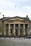 Upload another image |
| 1-16 (inclusive Nos) Buckingham Terrace [de], 2, 4 Buckingham Street, 1, 3 Ruskin Place | Great Western Road | 15 December 1970 | NS5702967267 | 55°52′38″N 4°17′13″W / 55.877279°N 4.286879°W / 55.877279; -4.286879 (1-16 (inclusive Nos) Buckingham Terrace [de], 2, 4 Buckingham Street, 1, 3 Ruskin Place) | J T Rochead, 1852-54. | 32850 | ![1-16 (inclusive Nos) Buckingham Terrace [de], 2, 4 Buckingham Street, 1, 3 Ruskin Place](http://upload.wikimedia.org/wikipedia/commons/thumb/7/70/Buckingham_Terrace_%28geograph_3654946%29.jpg/150px-Buckingham_Terrace_%28geograph_3654946%29.jpg) Upload another image |
| Lilybank House | University of Glasgow, Gilmorehill Campus | 15 December 1970 | NS5679666912 | 55°52′26″N 4°17′25″W / 55.874023°N 4.290412°W / 55.874023; -4.290412 (Lilybank House) | In the style of David Hamilton, built around 1850 and altered by A & G Thomson (1863-65) and Honeyman, Keppie & Mackintosh (1894-95; 1900 and 1908). | 32853 |  Upload another image |
| 35-51 (Odd Nos) Hamilton Drive [de], (1-9 Inclusive Nos) Northpark Terrace | Kelvinside | 15 December 1970 | NS5709767277 | 55°52′39″N 4°17′09″W / 55.877389°N 4.285798°W / 55.877389; -4.285798 (35-51 (Odd Nos) Hamilton Drive [de], (1-9 Inclusive Nos) Northpark Terrace) | Alexander Thomson, circa 1869. | 32874 | ![35-51 (Odd Nos) Hamilton Drive [de], (1-9 Inclusive Nos) Northpark Terrace](http://upload.wikimedia.org/wikipedia/commons/thumb/3/3b/35-51_%28Odd_Nos%29_Hamilton_Drive%2C.jpg/150px-35-51_%28Odd_Nos%29_Hamilton_Drive%2C.jpg) Upload another image |
| Cottier Theatre Complex | 93-95 (Odd Nos) Hyndland Street | 15 December 1970 | NS5607866959 | 55°52′27″N 4°18′07″W / 55.874231°N 4.301902°W / 55.874231; -4.301902 (Cottier Theatre Complex) | William Leiper 1865-66. Former Dowanhill Church and Halls. | 32879 |  Upload another image |
| Woodbank [de | 56 Partickhill Road | 15 December 1970 | NS5566267007 | 55°52′28″N 4°18′31″W / 55.874537°N 4.308571°W / 55.874537; -4.308571 (Woodbank [de) | Circa 1841. | 32895 | 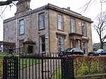 Upload another image |
| 1-9 (Inclusive Nos) Ruskin Terrace [de], 1, 1A, 3 Hamilton Park Avenue | 15 December 1970 | NS5723167155 | 55°52′35″N 4°17′01″W / 55.876334°N 4.283594°W / 55.876334; -4.283594 (1-9 (Inclusive Nos) Ruskin Terrace [de], 1, 1A, 3 Hamilton Park Avenue) | Circa 1855-58. | 32903 | ![1-9 (Inclusive Nos) Ruskin Terrace [de], 1, 1A, 3 Hamilton Park Avenue](http://upload.wikimedia.org/wikipedia/commons/thumb/c/c5/Ruskin_Terrace_%28geograph_2460531%29.jpg/150px-Ruskin_Terrace_%28geograph_2460531%29.jpg) Upload another image | |
| Wellington Church | 76 University Avenue | 6 July 1966 | NS5700466748 | 55°52′21″N 4°17′13″W / 55.872612°N 4.287004°W / 55.872612; -4.287004 (Wellington Church) | T L Watson, 1882-84. | 32912 |  Upload another image |
| Gilbert Scott Building and Memorial Chapel (with the Lion and Unicorn Staircase) | University of Glasgow, Gilmorehill Campus | 15 December 1970 | NS5687866664 | 55°52′19″N 4°17′20″W / 55.871821°N 4.288971°W / 55.871821; -4.288971 (Gilbert Scott Building and Memorial Chapel (with the Lion and Unicorn Staircase)) | Sir George Gilbert Scott (N, S and E elevations), 1867-1870; tower and spire finished 1891 by John Oldrid Scott. Later made into 2 quadrangles with the addition of Bute and Randolph Halls, designed by Sir George Gilbert Scott and executed by his son, John Oldrid Scott, and Edwin Morgan, 1878-84. West Quadrangle Sir John James Burnet, 1923-29. Lion and Unicorn Staircase, William Riddell, 1690 | 32913 |  Upload another image |
| Joseph Black Building | University of Glasgow, Gilmorehill Campus | 15 January 1985 | NS5661466700 | 55°52′19″N 4°17′36″W / 55.872065°N 4.293206°W / 55.872065; -4.293206 (Joseph Black Building) | T Harold Hughes with D S R Waugh, 1936-9. | 32918 |  Upload another image |
| Pearce Lodge | University of Glasgow, Gilmorehill Campus | 15 December 1970 | NS5707066668 | 55°52′19″N 4°17′09″W / 55.871914°N 4.285908°W / 55.871914; -4.285908 (Pearce Lodge) | A G Thomson, Architect & Civil Engineer, 1887. Incorporates decorative mid 17th-century sculptural fragments from demolished Old College (High Street) into exterior. | 32925 | 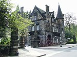 Upload another image |
| McMillan Reading Room | University of Glasgow, Gilmorehill Campus | 15 January 1985 | NS5693966755 | 55°52′22″N 4°17′17″W / 55.872656°N 4.288045°W / 55.872656; -4.288045 (McMillan Reading Room) | T Harold Hughes and D S R Waugh, 1936-39. | 32927 | 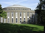 Upload another image |
| Graham Kerr Building | University of Glasgow, Gilmorehill Campus | 15 December 1970 | NS5662566631 | 55°52′17″N 4°17′35″W / 55.871449°N 4.292994°W / 55.871449; -4.292994 (Graham Kerr Building) | Sir John James Burnet, 1923-27 | 32928 |  Upload another image |
| 2-10 (inclusive) University Gardens | University of Glasgow, Gilmorehill Campus | 15 December 1970 | NS5680766794 | 55°52′23″N 4°17′25″W / 55.872967°N 4.290174°W / 55.872967; -4.290174 (2-10 (inclusive) University Gardens) | John James Burnet, 1882-96. | 32931 |  Upload another image |
| Salmon House (12 University Gardens) | University of Glasgow, Gilmorehill Campus | 15 December 1970 | NS5677966820 | 55°52′23″N 4°17′26″W / 55.873192°N 4.290635°W / 55.873192; -4.290635 (Salmon House (12 University Gardens)) | J Gaff Gillespie, 1900. | 32932 |  Upload another image |
| 14 University Gardens | University of Glasgow, Gilmorehill Campus | 15 December 1970 | NS5677366830 | 55°52′24″N 4°17′27″W / 55.87328°N 4.290736°W / 55.87328; -4.290736 (14 University Gardens) | John James Burnet, 1904. | 32933 |  Upload another image |
| The Salon [de | 17 Vinicombe Street | 22 March 1977 | NS5679167237 | 55°52′37″N 4°17′26″W / 55.876939°N 4.290664°W / 55.876939; -4.290664 (The Salon [de) | Brand and Lithgow, 1913; altered 1931 by James McKissack and 1940 by Burnet and Boston, converted to Salon restaurant 2007. | 32934 |  Upload another image |
| Former Botanic Gardens Garage | 24 Vinicombe Street | 6 February 1989 | NS5683867267 | 55°52′38″N 4°17′24″W / 55.877222°N 4.289929°W / 55.877222; -4.289929 (Former Botanic Gardens Garage) | D V Wyllie, circa 1906-12. | 32935 |  Upload another image |
| Savings Bank of Glasgow [de] | 752-756 (Even Nos) Argyle Street and 3, 5, 7 Shaftesbury Street | 15 December 1970 | NS5776665519 | 55°51′42″N 4°16′27″W / 55.861804°N 4.274191°W / 55.861804; -4.274191 (Savings Bank of Glasgow [de]) | James Salmon junior and J Gaff Gillespie, 1899-1900, sculpture by Albert Hodge. | 32953 | ![Savings Bank of Glasgow [de]](http://upload.wikimedia.org/wikipedia/commons/thumb/7/75/Former_Savings_Bank_of_Glasgow_%28geograph_3486736%29.jpg/150px-Former_Savings_Bank_of_Glasgow_%28geograph_3486736%29.jpg) Upload another image |
| 181-199 (Odd Nos) Bath Street [de] and Blythswood Street | 15 December 1970 | NS5847165788 | 55°51′52″N 4°15′47″W / 55.864427°N 4.263077°W / 55.864427; -4.263077 (181-199 (Odd Nos) Bath Street [de] and Blythswood Street) | Probably John Baird I, begun 1833; with later block by Andrew Robertson, 1930-2. Includes the Glasgow Art Club | 32960 | ![181-199 (Odd Nos) Bath Street [de] and Blythswood Street](http://upload.wikimedia.org/wikipedia/commons/thumb/d/da/181-199_%28Odd_Nos%29_Bath_Street.jpg/150px-181-199_%28Odd_Nos%29_Bath_Street.jpg) Upload another image | |
| King's Theatre | 335 Bath Street and Elmbank Street | 15 December 1970 | NS5811965874 | 55°51′54″N 4°16′07″W / 55.865095°N 4.268741°W / 55.865095; -4.268741 (King's Theatre) | Frank Matcham, 1903-04. | 32963 |  Upload another image |
| Mercantile Chambers [de] | 39-69 (Odd Nos) Bothwell Street | 15 December 1970 | NS5858165401 | 55°51′40″N 4°15′40″W / 55.860985°N 4.261118°W / 55.860985; -4.261118 (Mercantile Chambers [de]) | James Salmon junior, 1897-8. Sculptor Derwent Wood. | 32980 | ![Mercantile Chambers [de]](http://upload.wikimedia.org/wikipedia/commons/thumb/7/7c/Mercantile_Chambers.jpg/150px-Mercantile_Chambers.jpg) Upload another image |
| 2-28 (Even Nos) Bothwell Street [de], 123 Hope Street | 24 July 1973 | NS5871365426 | 55°51′40″N 4°15′32″W / 55.861248°N 4.259024°W / 55.861248; -4.259024 (2-28 (Even Nos) Bothwell Street [de], 123 Hope Street) | Alexander Kirkland and John Bryce, 1849. The western pavilion was replaced by the National Commercial Bank, H E Clifford 1892. | 32983 | ![2-28 (Even Nos) Bothwell Street [de], 123 Hope Street](http://upload.wikimedia.org/wikipedia/commons/thumb/7/7c/2-28_%28Even_Nos%29_Bothwell_Street.jpg/150px-2-28_%28Even_Nos%29_Bothwell_Street.jpg) Upload another image | |
| 21-31 (Odd Nos) (Known As 21) Buchanan Street [de] and 8-28 (Even Nos) Mitchell Street | 15 December 1970 | NS5891865134 | 55°51′31″N 4°15′20″W / 55.858686°N 4.2556°W / 55.858686; -4.2556 (21-31 (Odd Nos) (Known As 21) Buchanan Street [de] and 8-28 (Even Nos) Mitchell Street) | William Spence, circa 1879. | 32991 | ![21-31 (Odd Nos) (Known As 21) Buchanan Street [de] and 8-28 (Even Nos) Mitchell Street](http://upload.wikimedia.org/wikipedia/commons/thumb/1/18/Fraser%27s%2C_Buchanan_St%2C_Glasgow%2C_2018-06-30_HDR.jpg/150px-Fraser%27s%2C_Buchanan_St%2C_Glasgow%2C_2018-06-30_HDR.jpg) Upload another image | |
| Former Wylie and Lochead's [de] | 45 Buchanan Street and 34-50 (Even Nos) Mitchell Street | 23 March 1977 | NS5893165178 | 55°51′33″N 4°15′19″W / 55.859085°N 4.255415°W / 55.859085; -4.255415 (Former Wylie and Lochead's [de]) | South section of Buchanan Street frontage 1853-4. Central section James Sellars 1884. North section Boucher and Cousland after 1883. | 32992 | ![Former Wylie and Lochead's [de]](http://upload.wikimedia.org/wikipedia/commons/thumb/c/cb/45_Buchanan_Street%2C_Glasgow.jpg/84px-45_Buchanan_Street%2C_Glasgow.jpg) Upload another image |
| 91 Buchanan Street [de] | 15 December 1970 | NS5897765269 | 55°51′36″N 4°15′17″W / 55.859916°N 4.254728°W / 55.859916; -4.254728 (91 Buchanan Street [de]) | Sir George Washington Browne, 1896. | 32998 | ![91 Buchanan Street [de]](http://upload.wikimedia.org/wikipedia/commons/thumb/6/6c/91_Buchanan_Street_%28geograph_3755088%29.jpg/112px-91_Buchanan_Street_%28geograph_3755088%29.jpg) Upload another image | |
| 113-115 (Odd Nos) Buchanan Street [de] and 4 Gordon Street | 15 December 1970 | NS5899965335 | 55°51′38″N 4°15′16″W / 55.860515°N 4.254411°W / 55.860515; -4.254411 (113-115 (Odd Nos) Buchanan Street [de] and 4 Gordon Street) | A G Sydney Mitchell, 1887. | 33000 | ![113-115 (Odd Nos) Buchanan Street [de] and 4 Gordon Street](http://upload.wikimedia.org/wikipedia/commons/thumb/5/50/113-115_%28ODD_NOS%29_BUCHANAN_STREET_AND_4_GORDON_STREET.jpg/112px-113-115_%28ODD_NOS%29_BUCHANAN_STREET_AND_4_GORDON_STREET.jpg) Upload another image | |
| Former Western Club | 147 Buchanan Street and St Vincent Street | 15 December 1970 | NS5901865433 | 55°51′41″N 4°15′15″W / 55.8614°N 4.254159°W / 55.8614; -4.254159 (Former Western Club) | D and J Hamilton with the assistance of J T Rochead, 1841. | 33002 |  Upload another image |
| St George's Tron Parish Church | 163 Buchanan Street | 6 July 1966 | NS5903265500 | 55°51′43″N 4°15′14″W / 55.862006°N 4.25397°W / 55.862006; -4.25397 (St George's Tron Parish Church) | William Stark, 1807. Church of Scotland. | 33003 |  Upload another image |
| Former Athenaeum Theatre [de] | 179 Buchanan Street | 6 July 1966 | NS5903765562 | 55°51′45″N 4°15′14″W / 55.862564°N 4.253923°W / 55.862564; -4.253923 (Former Athenaeum Theatre [de]) | Sir J J Burnet and J A Campbell, 1891-3. | 33004 | ![Former Athenaeum Theatre [de]](http://upload.wikimedia.org/wikipedia/commons/thumb/a/a1/The_Old_Athanaeum%2C_Buchanan_Street%2C_Glasgow.jpg/112px-The_Old_Athanaeum%2C_Buchanan_Street%2C_Glasgow.jpg) Upload another image |
| No 4 Clairmont Gardens | 15 December 1970 | NS5759266077 | 55°52′00″N 4°16′38″W / 55.866762°N 4.277262°W / 55.866762; -4.277262 (No 4 Clairmont Gardens) | Previously included in listing of nos 2-13 Clairmont Gardens [de]. Up-graded B to A 28 September 1994 and included as a separate item due to high quality of interior work. | 33008 |  Upload another image | |
| Former Custom House [de] | 298-306 (Even Nos) Clyde Street | 15 December 1970 | NS5884764881 | 55°51′23″N 4°15′24″W / 55.856394°N 4.256601°W / 55.856394; -4.256601 (Former Custom House [de]) | John Taylor, 1840. Now Office of Procurator Fiscal. | 33012 | ![Former Custom House [de]](http://upload.wikimedia.org/wikipedia/commons/thumb/b/b6/Custom_House_-_geograph.org.uk_-_943624.jpg/150px-Custom_House_-_geograph.org.uk_-_943624.jpg) Upload another image |
| 49 Derby Street [de], 22, 30 Bentinck Street | 6 July 1966 | NS5711766068 | 55°52′00″N 4°17′05″W / 55.866541°N 4.284841°W / 55.866541; -4.284841 (49 Derby Street [de], 22, 30 Bentinck Street) | James Sellars, 1879-80. | 33015 | ![49 Derby Street [de], 22, 30 Bentinck Street](http://upload.wikimedia.org/wikipedia/commons/thumb/0/09/Former_Kelvingrove_Parish_Church%2C_Derby_Street%2C_Glasgow.jpg/150px-Former_Kelvingrove_Parish_Church%2C_Derby_Street%2C_Glasgow.jpg) Upload another image | |
| 17-21 (Odd Nos) Drury Street | Including "The Horse Shoe Bar" | 21 July 1988 | NS5887365371 | 55°51′39″N 4°15′23″W / 55.860801°N 4.256441°W / 55.860801; -4.256441 (17-21 (Odd Nos) Drury Street) | Circa 1870, interior remodelled 1885-87 and 1901. Unknown architect, after Alexander Thomson. | 33016 |  Upload another image |
| 120 Elmbank Street [de] with 71-83 (Odd Nos) Holland Street and Lodges, 59, 61 Holland Street | 15 December 1970 | NS5817865784 | 55°51′51″N 4°16′04″W / 55.864305°N 4.267752°W / 55.864305; -4.267752 (120 Elmbank Street [de] with 71-83 (Odd Nos) Holland Street and Lodges, 59, 61 Holland Street) | Main block, Charles Wilson, 1846. Sculptures by John Mossman. 71-83 Holland St: J L Cowan, completed 1897. Science Block: John Watson 1931-32. Lodges, Holland St: Watson, Salmond and Gray, 1938. | 33022 | ![120 Elmbank Street [de] with 71-83 (Odd Nos) Holland Street and Lodges, 59, 61 Holland Street](http://upload.wikimedia.org/wikipedia/commons/thumb/d/d3/120%2C_Elmbank_Street_with_71-83_%28Odd_Nos%29_Holland_Street_and_Lodges%2C_59%2C_61_Holland_Street.jpg/150px-120%2C_Elmbank_Street_with_71-83_%28Odd_Nos%29_Holland_Street_and_Lodges%2C_59%2C_61_Holland_Street.jpg) Upload another image | |
| Central Station & Hotel | Gordon Street | 15 December 1970 | NS5872765252 | 55°51′35″N 4°15′31″W / 55.85969°N 4.25871°W / 55.85969; -4.25871 (Central Station & Hotel) | Sir R Rowand Anderson, 1883-4. Extensive additions to Hope Street, James Miller 1900-1907. | 33029 |  Upload another image |
| 6 Gordon Street [de], Part of Former Commercial Bank | 6 July 1966 | NS5895965350 | 55°51′38″N 4°15′18″W / 55.860638°N 4.255058°W / 55.860638; -4.255058 (6 Gordon Street [de], Part of Former Commercial Bank) | David Rhind, 1854-7. | 33030 | ![6 Gordon Street [de], Part of Former Commercial Bank](http://upload.wikimedia.org/wikipedia/commons/thumb/c/c4/6_Gordon_Street%2C_Glasgow.jpg/150px-6_Gordon_Street%2C_Glasgow.jpg) Upload another image | |
| 20-40 (Even Nos) Gordon Street [de] and 1, 3 West Nile Street | 15 December 1970 | NS5889765358 | 55°51′38″N 4°15′22″W / 55.860691°N 4.256052°W / 55.860691; -4.256052 (20-40 (Even Nos) Gordon Street [de] and 1, 3 West Nile Street) | Peddie and Kinnear, 1873. | 33031 | ![20-40 (Even Nos) Gordon Street [de] and 1, 3 West Nile Street](http://upload.wikimedia.org/wikipedia/commons/thumb/c/c7/20-40_%28Even_Nos%29_Gordon_Street_and_1%2C_3_West_Nile_Street.jpg/150px-20-40_%28Even_Nos%29_Gordon_Street_and_1%2C_3_West_Nile_Street.jpg) Upload another image | |
| Grosvenor Building [de] | 72-80 (Even Nos) Gordon Street | 15 December 1970 | NS5879365372 | 55°51′39″N 4°15′28″W / 55.860786°N 4.257719°W / 55.860786; -4.257719 (Grosvenor Building [de]) | Alexander Thomson, 1864, with later additional storeys by J H Craigie, 1902-07. | 33034 | ![Grosvenor Building [de]](http://upload.wikimedia.org/wikipedia/commons/thumb/c/c6/Grosvenor_Building.jpg/112px-Grosvenor_Building.jpg) Upload another image |
| Mitchell Theatre | Granville Street, Berkeley Street and Kent Road | 6 July 1966 | NS5782365843 | 55°51′53″N 4°16′24″W / 55.86473°N 4.273451°W / 55.86473; -4.273451 (Mitchell Theatre) | James Sellars, 1873-77, interior reconstructed. Sculpture by John Mossman at 1st floor. William Mossman at ground floor. Formerly St Andrew's Halls. | 33036 |  Upload another image |
| Breadalbane Terrace [de] | 97-113B (Odd Nos) Hill Street | 15 December 1970 | NS5832466078 | 55°52′01″N 4°15′56″W / 55.866987°N 4.265575°W / 55.866987; -4.265575 (Breadalbane Terrace [de]) | Possibly Charles Wilson. Built in 2 sections 1845-6 and 1855-6. | 33038 | ![Breadalbane Terrace [de]](http://upload.wikimedia.org/wikipedia/commons/thumb/5/57/Breadalbane_Terrace.jpg/150px-Breadalbane_Terrace.jpg) Upload another image |
| Hill Street Synagogue | 129 Hill Street and 29 Garnet Street | 27 November 1979 | NS5819166096 | 55°52′02″N 4°16′04″W / 55.86711°N 4.267708°W / 55.86711; -4.267708 (Hill Street Synagogue) | John McLeod, in association with N.S. Joseph, 1877-79. | 33040 |  Upload another image |
| Peel Terrace [de] | 102-112 (Even Nos) Hill Street, and 37, 39 Garnethill Street | 11 May 1981 | NS5831066135 | 55°52′03″N 4°15′57″W / 55.867495°N 4.265828°W / 55.867495; -4.265828 (Peel Terrace [de]) | 1841-2. Possibly David Hamilton. | 33044 | ![Peel Terrace [de]](http://upload.wikimedia.org/wikipedia/commons/thumb/a/a9/Hill_Street_-_geograph.org.uk_-_1179342.jpg/112px-Hill_Street_-_geograph.org.uk_-_1179342.jpg) Upload another image |
| Atlantic Chambers [de] | 43, 45, 47 Hope Street and 1A Cadogan Street | 15 December 1970 | NS5867665241 | 55°51′34″N 4°15′34″W / 55.859576°N 4.259519°W / 55.859576; -4.259519 (Atlantic Chambers [de]) | Sir J J Burnet, 1899. | 33050 | ![Atlantic Chambers [de]](http://upload.wikimedia.org/wikipedia/commons/thumb/0/06/Atlantic_Chambers.jpg/112px-Atlantic_Chambers.jpg) Upload another image |
| Central Chambers [de | 91-115 (Odd Nos) Hope Street, 2-14 (Even Nos) Waterloo Street and 1-13 (Odd Nos) Bothwell Street | 15 December 1970 | NS5868565349 | 55°51′38″N 4°15′34″W / 55.860548°N 4.259431°W / 55.860548; -4.259431 (Central Chambers [de) | Peddie and Kinnear, 1876-77. | 33052 |  Upload another image |
| 157-167 (Odd Nos) Hope Street [de] and 169-175 (Odd Nos) West George Street | 6 July 1966 | NS5874765544 | 55°51′44″N 4°15′31″W / 55.862317°N 4.258543°W / 55.862317; -4.258543 (157-167 (Odd Nos) Hope Street [de] and 169-175 (Odd Nos) West George Street) | John A Campbell, 1902. | 33053 | ![157-167 (Odd Nos) Hope Street [de] and 169-175 (Odd Nos) West George Street](http://upload.wikimedia.org/wikipedia/commons/thumb/8/8d/157-167_%28Odd_Nos%29_Hope_Street_and_169-175_%28Odd_Nos%29_West_George_Street.jpg/112px-157-167_%28Odd_Nos%29_Hope_Street_and_169-175_%28Odd_Nos%29_West_George_Street.jpg) Upload another image | |
| 106, 108, 110 Hope Street [de] (Known As 108) | 15 December 1979 | NS5876165413 | 55°51′40″N 4°15′30″W / 55.861145°N 4.258251°W / 55.861145; -4.258251 (106, 108, 110 Hope Street [de] (Known As 108)) | W Forrest Salmon, 1894 assisted by J Gaff Gillespie and James Salmon, sculpture by W Ferris. | 33056 | ![106, 108, 110 Hope Street [de] (Known As 108)](http://upload.wikimedia.org/wikipedia/commons/thumb/7/7a/106%2C_108_Hope_Street%2C_Scottish_Temperance_League_Offices.jpg/84px-106%2C_108_Hope_Street%2C_Scottish_Temperance_League_Offices.jpg) Upload another image | |
| Lion Chambers | 170, 172 Hope Street | 6 July 1966 | NS5882665673 | 55°51′49″N 4°15′26″W / 55.863498°N 4.257349°W / 55.863498; -4.257349 (Lion Chambers) | James Salmon Jr., 1905. | 33059 | 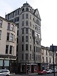 Upload another image |
| Theatre Royal | 282 Hope Street, Cowcaddens | 22 March 1977 | NS5890565980 | 55°51′59″N 4°15′22″W / 55.866278°N 4.256248°W / 55.866278; -4.256248 (Theatre Royal) | George Bell, 1867; burnt down 1879, restoration after fire by Charles J Phipps, 1880. Further fire, also rebuilt by Phipps, 1895, in similar scheme to previous one; altered James Miller 1901; restored and new foyer Derek Sugden of Arup Associates 1974-5. | 33061 | 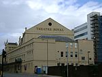 Upload another image |
| Gardner's Warehouse [de] | 36 Jamaica Street and 10 Midland Street | 6 July 1966 | NS5879865017 | 55°51′27″N 4°15′27″W / 55.857601°N 4.257454°W / 55.857601; -4.257454 (Gardner's Warehouse [de]) | John Baird I and R McConnel iron founder, 1855-56. Early example of Iron Frame architecture.[17] | 33065 | ![Gardner's Warehouse [de]](http://upload.wikimedia.org/wikipedia/commons/thumb/c/c8/Gardners_Warehouse%2C_Jamaica_Street_Glasgow.jpg/150px-Gardners_Warehouse%2C_Jamaica_Street_Glasgow.jpg) Upload another image |
| Atlantic Apartments [de] | 69 James Watt Street | 15 December 1970 | NS5838365127 | 55°51′30″N 4°15′51″W / 55.858467°N 4.264136°W / 55.858467; -4.264136 (Atlantic Apartments [de]) | Circa 1855. | 33068 | ![Atlantic Apartments [de]](http://upload.wikimedia.org/wikipedia/commons/thumb/2/2d/69_James_Watt_Street.jpg/150px-69_James_Watt_Street.jpg) Upload another image |
| 44-54 James Watt Street [de] | 15 December 1970 | NS5840165104 | 55°51′30″N 4°15′50″W / 55.858265°N 4.263837°W / 55.858265; -4.263837 (44-54 James Watt Street [de]) | Circa 1863. | 33069 | ![44-54 James Watt Street [de]](http://upload.wikimedia.org/wikipedia/commons/thumb/6/6a/44-54_James_Watt_Street.jpg/150px-44-54_James_Watt_Street.jpg) Upload another image | |
| 66-72 James Watt Street [de] | 15 December 1970 | NS5840165104 | 55°51′30″N 4°15′50″W / 55.858265°N 4.263837°W / 55.858265; -4.263837 (66-72 James Watt Street [de]) | Probably J Stephen 1847-8. | 33070 | ![66-72 James Watt Street [de]](http://upload.wikimedia.org/wikipedia/commons/thumb/6/63/66_watt_st_glasgow.jpg/150px-66_watt_st_glasgow.jpg) Upload another image | |
| Kelvingrove Art Gallery and Museum | Kelvingrove Park | 15 December 1970 | NS5676266309 | 55°52′07″N 4°17′26″W / 55.868599°N 4.290636°W / 55.868599; -4.290636 (Kelvingrove Art Gallery and Museum) | J W Simpson and Milner Allen, 1892 by competition, completed 1901; sculpture supervised and partly executed by George Frampton, other sculptors involved, W Birnie Rhind, E G Bramwell, Johann Keller, A McF Shannon, F Derwent Wood, A Falkner. | 33071 |  Upload another image |
| Hindu Mandir [de] | 1 La Belle Place | 6 July 1966 | NS5746766059 | 55°52′00″N 4°16′45″W / 55.866564°N 4.279248°W / 55.866564; -4.279248 (Hindu Mandir [de]) | Charles Wilson, 1857. Former Queen's Rooms. | 33082 | ![Hindu Mandir [de]](http://upload.wikimedia.org/wikipedia/commons/thumb/f/f2/1_La_Belle_Place.jpg/150px-1_La_Belle_Place.jpg) Upload another image |
| 2–5 La Belle Place [de] | 15 December 1970 | NS5743366058 | 55°52′00″N 4°16′47″W / 55.866545°N 4.27979°W / 55.866545; -4.27979 (2–5 La Belle Place [de]) | Charles Wilson, 1857. | 33083 | ![2–5 La Belle Place [de]](http://upload.wikimedia.org/wikipedia/commons/thumb/3/3d/2-5_%28inclusive_Nos%29_La_Belle_Place.jpg/150px-2-5_%28inclusive_Nos%29_La_Belle_Place.jpg) Upload another image | |
| Former Glasgow Herald Building | 60-76 (Even Nos) Mitchell Street | 15 December 1970 | NS5892465238 | 55°51′35″N 4°15′20″W / 55.859622°N 4.255558°W / 55.859622; -4.255558 (Former Glasgow Herald Building) | John Keppie and Charles Rennie Mackintosh, 1893-5. | 33087 |  Upload another image |
| Glasgow Stock Exchange | 63-77 (Odd Nos) Nelson Mandela Place, West George Street with 153-159 (Odd Nos) Buchanan Street | 15 December 1970 | NS5902465464 | 55°51′42″N 4°15′15″W / 55.86168°N 4.254079°W / 55.86168; -4.254079 (Glasgow Stock Exchange) | John Burnet 1875-7; Sir J J Burnet western addition 1894-8 and 1904, re-cast behind the facade. | 33089 |  Upload another image |
| Former Daily Record Building [de] | 20, 26, 28 Renfield Lane and St Vincent Lane | 15 December 1970 | NS5878865410 | 55°51′40″N 4°15′28″W / 55.861126°N 4.257819°W / 55.861126; -4.257819 (Former Daily Record Building [de]) | Charles Rennie Mackintosh, 1900-01 and 1903-04. | 33099 | ![Former Daily Record Building [de]](http://upload.wikimedia.org/wikipedia/commons/thumb/1/1c/The_Daily_Record_Printing_Works_in_Renfield_Lane_-_panoramio.jpg/112px-The_Daily_Record_Printing_Works_in_Renfield_Lane_-_panoramio.jpg) Upload another image |
| Pavilion Theatre | 121-125 Renfield Street | 22 March 1977 | NS5893065844 | 55°51′54″N 4°15′21″W / 55.865064°N 4.255778°W / 55.865064; -4.255778 (Pavilion Theatre) | Bertie Crewe, 1902-4. | 33103 |  Upload another image |
| Glasgow School of Art | 167 Renfrew Street and 11, 15 Dalhousie Street | 6 July 1966 | NS5843565969 | 55°51′58″N 4°15′49″W / 55.866041°N 4.263746°W / 55.866041; -4.263746 (Glasgow School of Art) | Charles Rennie Mackintosh, Eastern section, 1897. Western section, 1907-9. | 33105 |  Upload another image |
| 71–75 Robertson Street [de] and 58, 60 Robertson Lane | 15 December 1970 | NS5854265096 | 55°51′30″N 4°15′42″W / 55.858235°N 4.261582°W / 55.858235; -4.261582 (71–75 Robertson Street [de] and 58, 60 Robertson Lane) | J A Campbell 1901. | 33112 | ![71–75 Robertson Street [de] and 58, 60 Robertson Lane](http://upload.wikimedia.org/wikipedia/commons/thumb/6/61/71-75_%28Odd_Nos%29_Robertson_Street_and_58%2C_60_Robertson_Lane.jpg/150px-71-75_%28Odd_Nos%29_Robertson_Street_and_58%2C_60_Robertson_Lane.jpg) Upload another image | |
| Clyde Navigation Trust [de] | 16 Robertson Street | 6 July 1966 | NS5858664962 | 55°51′25″N 4°15′39″W / 55.857045°N 4.26081°W / 55.857045; -4.26081 (Clyde Navigation Trust [de]) | Sir J J Burnet. 1883-6 North section. 1905-8 corner with Broomielaw. Sculpture by Albert Hodge. | 33113 | ![Clyde Navigation Trust [de]](http://upload.wikimedia.org/wikipedia/commons/thumb/4/44/Clydeport_building_-_geograph.org.uk_-_1481376.jpg/122px-Clydeport_building_-_geograph.org.uk_-_1481376.jpg) Upload another image |
| St Aloysius' Church (Roman Catholic) | 23, 25 Rose Street | 15 December 1970 | NS5855966016 | 55°51′59″N 4°15′42″W / 55.8665°N 4.261791°W / 55.8665; -4.261791 (St Aloysius' Church (Roman Catholic)) | C J Menart, 1908-10. | 33115 | 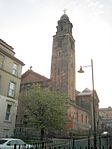 Upload another image |
| Charing Cross Mansions [de] | 2-30 (Even Nos) St George's Road, 540-546 (Even Nos) Sauchiehall Street and 357,359 Renfrew Street | 15 December 1970 | NS5801766047 | 55°52′00″N 4°16′14″W / 55.866619°N 4.27046°W / 55.866619; -4.27046 (Charing Cross Mansions [de]) | Sir J J Burnet, 1891. | 33127 | ![Charing Cross Mansions [de]](http://upload.wikimedia.org/wikipedia/commons/thumb/e/e4/Charing_Cross_Mansions%2C_Glasgow_%28geograph_4137464%29.jpg/150px-Charing_Cross_Mansions%2C_Glasgow_%28geograph_4137464%29.jpg) Upload another image |
| 19–30 St Vincent Crescent [de] (Excluding Nos 23, 23A, 23B, 26A) and 21 Corunna Street | 15 December 1970 | NS5720465704 | 55°51′48″N 4°17′00″W / 55.863299°N 4.28326°W / 55.863299; -4.28326 (19–30 St Vincent Crescent [de] (Excluding Nos 23, 23A, 23B, 26A) and 21 Corunna Street) | Alexander Kirkland, circa 1855. | 33128 | ![19–30 St Vincent Crescent [de] (Excluding Nos 23, 23A, 23B, 26A) and 21 Corunna Street](http://upload.wikimedia.org/wikipedia/commons/thumb/f/fb/Minerva_Street_at_St_Vincent_Crescent_-_geograph.org.uk_-_666286.jpg/150px-Minerva_Street_at_St_Vincent_Crescent_-_geograph.org.uk_-_666286.jpg) Upload another image | |
| 31–70 St Vincent Crescent [de] (Excluding Nos 35A,36A,37A,39A) and 30 Corunna Street | 15 December 1970 | NS5685865806 | 55°51′51″N 4°17′20″W / 55.864112°N 4.288837°W / 55.864112; -4.288837 (31–70 St Vincent Crescent [de] (Excluding Nos 35A,36A,37A,39A) and 30 Corunna Street) | Alexander Kirkland, 1850 onwards. | 33129 | ![31–70 St Vincent Crescent [de] (Excluding Nos 35A,36A,37A,39A) and 30 Corunna Street](http://upload.wikimedia.org/wikipedia/commons/thumb/6/66/St_Vincent_Crescent_-_geograph.org.uk_-_890077.jpg/150px-St_Vincent_Crescent_-_geograph.org.uk_-_890077.jpg) Upload another image | |
| 115–117 St Vincent Street [de] | 15 December 1970 | NS5878765434 | 55°51′41″N 4°15′28″W / 55.861341°N 4.257847°W / 55.861341; -4.257847 (115–117 St Vincent Street [de]) | John Burnet Sr, 1870. | 33138 | ![115–117 St Vincent Street [de]](http://upload.wikimedia.org/wikipedia/commons/thumb/4/4d/115%2C_115a%2C_117_St_Vincent_Street%2C_Glasgow.jpg/84px-115%2C_115a%2C_117_St_Vincent_Street%2C_Glasgow.jpg) Upload another image | |
| St Vincent Street Church | 261 St Vincent Street | 6 July 1966 | NS5831365551 | 55°51′44″N 4°15′56″W / 55.862253°N 4.265475°W / 55.862253; -4.265475 (St Vincent Street Church) | Alexander Thomson, 1857-59. Former United Free Church of Scotland, now Free Church. | 33150 |  Upload another image |
| 84–94 St Vincent Street [de] | 15 December 1970 | NS5890765456 | 55°51′42″N 4°15′21″W / 55.861574°N 4.255943°W / 55.861574; -4.255943 (84–94 St Vincent Street [de]) | John A Campbell 1908-9. | 33153 | ![84–94 St Vincent Street [de]](http://upload.wikimedia.org/wikipedia/commons/thumb/c/ce/84-94_%28Even_Nos%29_St_Vincent_Street.jpg/112px-84-94_%28Even_Nos%29_St_Vincent_Street.jpg) Upload another image | |
| Bank of Scotland (110–120 St Vincent Street [de]) | 110, 120 St Vincent Street and 29-37 (Odd Nos) Renfield Street and West George Lane | 15 December 1970 | NS5883665490 | 55°51′43″N 4°15′26″W / 55.861858°N 4.257094°W / 55.861858; -4.257094 (Bank of Scotland (110–120 St Vincent Street [de])) | James Miller, 1925-27. | 33156 | ![Bank of Scotland (110–120 St Vincent Street [de])](http://upload.wikimedia.org/wikipedia/commons/thumb/f/f7/110%2C_120_St_Vincent_Street_and_29-37_%28Odd_Nos%29_Renfield_Street_and_West_George_Lane.jpg/112px-110%2C_120_St_Vincent_Street_and_29-37_%28Odd_Nos%29_Renfield_Street_and_West_George_Lane.jpg) Upload another image |
| Royal Bank Building [de | 140, 142 St Vincent Street and 153, 155 Hope Street | 21 July 1988 | NS5874765494 | 55°51′43″N 4°15′31″W / 55.861868°N 4.258517°W / 55.861868; -4.258517 (Royal Bank Building [de) | Burnet and Boston, circa 1900. | 33159 |  Upload another image |
| 142a–144 St Vincent Street [de] | The "Hatrack" | 6 July 1966 | NS5873765497 | 55°51′43″N 4°15′31″W / 55.861892°N 4.258678°W / 55.861892; -4.258678 (142a–144 St Vincent Street [de]) | James Salmon Jnr, 1899-1902. | 33160 | ![142a–144 St Vincent Street [de]](http://upload.wikimedia.org/wikipedia/commons/thumb/e/e2/142A%2C_144_St_Vincent_Street.jpg/112px-142A%2C_144_St_Vincent_Street.jpg) Upload another image |
| 200 St Vincent Street [de] | 6 July 1966 | NS5859665543 | 55°51′44″N 4°15′39″W / 55.862264°N 4.260953°W / 55.862264; -4.260953 (200 St Vincent Street [de]) | Sir J J Burnet, 1926-9, major internal remodelling 1986/7. | 33162 | ![200 St Vincent Street [de]](http://upload.wikimedia.org/wikipedia/commons/thumb/b/bf/200_St_Vincent_Street.jpg/112px-200_St_Vincent_Street.jpg) Upload another image | |
| Willow Tearooms | 217 Sauchiehall Street | 15 December 1970 | NS5859465838 | 55°51′54″N 4°15′40″W / 55.864912°N 4.261139°W / 55.864912; -4.261139 (Willow Tearooms) | Designed by Charles Rennie Mackintosh and Margaret Macdonald in 1903. | 33173 |  Upload another image |
| 901–903 Sauchiehall Street [de] | 15 December 1970 | NS5712865932 | 55°51′55″N 4°17′05″W / 55.865323°N 4.284593°W / 55.865323; -4.284593 (901–903 Sauchiehall Street [de]) | Charles Wilson, 1853. | 33184 | ![901–903 Sauchiehall Street [de]](http://upload.wikimedia.org/wikipedia/commons/thumb/4/4c/901%2C_903_Sauchiehall_Street.jpg/150px-901%2C_903_Sauchiehall_Street.jpg) Upload another image | |
| 336-356 (Even Nos) Sauchiehall Street [de] and 1 Scott Street | 15 December 1970 | NS5835265943 | 55°51′57″N 4°15′54″W / 55.865783°N 4.265057°W / 55.865783; -4.265057 (336-356 (Even Nos) Sauchiehall Street [de] and 1 Scott Street) | Alexander Thomson, 1865. | 33193 | ![336-356 (Even Nos) Sauchiehall Street [de] and 1 Scott Street](http://upload.wikimedia.org/wikipedia/commons/thumb/e/e8/336-356_Sauchiehall_Street%2C_Grecian_Chambers.jpg/150px-336-356_Sauchiehall_Street%2C_Grecian_Chambers.jpg) Upload another image | |
| Albany Chambers [de] | 528-538 (Even Nos) Sauchiehall Street | 15 December 1970 | NS5804066017 | 55°51′59″N 4°16′12″W / 55.866356°N 4.270077°W / 55.866356; -4.270077 (Albany Chambers [de]) | Sir J J Burnet, 1896-7. | 33199 | ![Albany Chambers [de]](http://upload.wikimedia.org/wikipedia/commons/thumb/e/ee/534_Sauchiehall_Street%2C_Albany_Chambers.jpg/84px-534_Sauchiehall_Street%2C_Albany_Chambers.jpg) Upload another image |
| The Egyptian Halls | 84-100 Union Street | 6 July 1966 | NS5886165263 | 55°51′35″N 4°15′24″W / 55.859828°N 4.256577°W / 55.859828; -4.256577 (The Egyptian Halls) | Alexander Thomson, 1871-3. | 33208 |  Upload another image |
| Ca d’Oro Building | 122-136 (Even Nos) Union Street and 41-55 (Odd Nos) Gordon Street and Union Place | 15 December 1970 | NS5886465320 | 55°51′37″N 4°15′24″W / 55.86034°N 4.256559°W / 55.86034; -4.256559 (Ca d’Oro Building) | John Honeyman, 1872. | 33209 |  Upload another image |
| Former Waterloo Street Post Office [de], Parcels Office | 50 Waterloo Street with 81 Wellington Street | 15 December 1970 | NS5858365364 | 55°51′38″N 4°15′40″W / 55.860653°N 4.261067°W / 55.860653; -4.261067 (Former Waterloo Street Post Office [de], Parcels Office) | W T Oldrieve (for the Office of Works), 1903-05. | 33214 | ![Former Waterloo Street Post Office [de], Parcels Office](http://upload.wikimedia.org/wikipedia/commons/thumb/f/f4/Former_Waterloo_Street_Post_Office%2C_Parcels_Office.jpg/150px-Former_Waterloo_Street_Post_Office%2C_Parcels_Office.jpg) Upload another image |
| Former Sun Life Building [de] | 117, 121 West George Street and 38-42 (Even Nos) Renfield Street | 15 December 1970 | NS5889365510 | 55°51′43″N 4°15′22″W / 55.862055°N 4.256195°W / 55.862055; -4.256195 (Former Sun Life Building [de]) | William Leiper, 1889-94. | 33223 | ![Former Sun Life Building [de]](http://upload.wikimedia.org/wikipedia/commons/thumb/0/01/117%2C_121_West_George_Street.jpg/112px-117%2C_121_West_George_Street.jpg) Upload another image |
| 4 Nelson Mandela Place [de] | 15 December 1970 | NS5904965538 | 55°51′44″N 4°15′13″W / 55.862352°N 4.253719°W / 55.862352; -4.253719 (4 Nelson Mandela Place [de]) | A N Paterson, 1908-10. | 33233 | ![4 Nelson Mandela Place [de]](http://upload.wikimedia.org/wikipedia/commons/thumb/a/a4/4_Nelson_Mandela_Place.jpg/112px-4_Nelson_Mandela_Place.jpg) Upload another image | |
| Former Athenaeum de | 8 Nelson Mandela Place | 6 July 1966 | NS5902465544 | 55°51′45″N 4°15′15″W / 55.862398°N 4.254121°W / 55.862398; -4.254121 (Former Athenaeum de) | Sir J J Burnet, 1886. | 33234 |  Upload another image |
| Royal Faculty of Procurators | 68 West George Street, 12 Nelson Mandela Place | 6 July 1966 | NS5899265526 | 55°51′44″N 4°15′17″W / 55.862227°N 4.254622°W / 55.862227; -4.254622 (Royal Faculty of Procurators) | Charles Wilson, 1854. | 33235 |  Upload another image |
| Cornhill House [de] | 144, 146 West George Street | 15 December 1970 | NS5882965580 | 55°51′46″N 4°15′26″W / 55.862664°N 4.257253°W / 55.862664; -4.257253 (Cornhill House [de]) | James Sellars, 1879 with sculpture by William Mossman. | 33241 | ![Cornhill House [de]](http://upload.wikimedia.org/wikipedia/commons/thumb/6/6b/144%2C_146_West_George_Street-2.jpg/112px-144%2C_146_West_George_Street-2.jpg) Upload another image |
| 196–198 West George Street [de] and 118 Wellington Street | 15 December 1970 | NS5870265604 | 55°51′46″N 4°15′33″W / 55.862843°N 4.259293°W / 55.862843; -4.259293 (196–198 West George Street [de] and 118 Wellington Street) | Circa 1830. Probably by John Brash. | 33246 | ![196–198 West George Street [de] and 118 Wellington Street](http://upload.wikimedia.org/wikipedia/commons/thumb/a/ab/Wellington_Street_-_geograph.org.uk_-_995605.jpg/115px-Wellington_Street_-_geograph.org.uk_-_995605.jpg) Upload another image | |
| Finnieston Crane | Stobcross Quay | 14 April 1989 | NS5710365150 | 55°51′30″N 4°17′04″W / 55.858295°N 4.28458°W / 55.858295; -4.28458 (Finnieston Crane) | 1926, completed 1931 by Cowans Sheldon and Co Ltd under the supervision of Daniel Fife Mechanical Engineer to the Clyde Navigation Trust. | 33285 |  Upload another image |
| 140–142 Balgrayhill Road [de], including Redclyffe | 22 March 1977 | NS6060768368 | 55°53′18″N 4°13′49″W / 55.888213°N 4.230303°W / 55.888213; -4.230303 (140–142 Balgrayhill Road [de], including Redclyffe) | Charles Rennie Mackintosh, 1890, for his cousin James Hamilton. | 33288 | ![140–142 Balgrayhill Road [de], including Redclyffe](http://upload.wikimedia.org/wikipedia/commons/thumb/4/43/140%2C_142_Balgrayhill_Road%2C_including_Redclyffe.jpg/150px-140%2C_142_Balgrayhill_Road%2C_including_Redclyffe.jpg) Upload another image | |
| Springburn Winter Gardens | Springburn Park | 22 March 1985 | NS6081468448 | 55°53′20″N 4°13′37″W / 55.888991°N 4.227037°W / 55.888991; -4.227037 (Springburn Winter Gardens) | Simpson and Farmer, hothouse builders, with William Baird of Temple ironworks, 1899-1900. | 33298 |  Upload another image |
| Elder Cottage Hospital [de] | 1A Drumoyne Drive and Langlands Road | 15 December 1970 | NS5440865496 | 55°51′38″N 4°19′40″W / 55.860595°N 4.327783°W / 55.860595; -4.327783 (Elder Cottage Hospital [de]) | Sir John James Burnet, 1902. | 33300 | ![Elder Cottage Hospital [de]](http://upload.wikimedia.org/wikipedia/commons/thumb/9/92/Former_Elder_Cottage_Hospital_-_geograph.org.uk_-_734464.jpg/150px-Former_Elder_Cottage_Hospital_-_geograph.org.uk_-_734464.jpg) Upload another image |
| Statue of Mrs John Elder [de] | Elder Park | 15 December 1970 | NS5455265587 | 55°51′41″N 4°19′32″W / 55.861455°N 4.325534°W / 55.861455; -4.325534 (Statue of Mrs John Elder [de]) | By Archibald McFarlane Shannan, RSA. | 33304 | ![Statue of Mrs John Elder [de]](http://upload.wikimedia.org/wikipedia/commons/thumb/6/6c/Statue_of_Isabella_Elder.JPG/150px-Statue_of_Isabella_Elder.JPG) Upload another image |
| Elder Park Library [de] | 228A Langlands Road and Elder Park Street | 15 December 1970 | NS5477765640 | 55°51′43″N 4°19′19″W / 55.861999°N 4.32197°W / 55.861999; -4.32197 (Elder Park Library [de]) | Sir John James Burnet, 1902-3. | 33310 | ![Elder Park Library [de]](http://upload.wikimedia.org/wikipedia/commons/thumb/8/84/Elder_Park_Library.jpg/150px-Elder_Park_Library.jpg) Upload another image |
| Govan Graving Docks [de] | 18 Clydebrae Street | 15 May 1987 | NS5609065462 | 55°51′39″N 4°18′03″W / 55.860795°N 4.300915°W / 55.860795; -4.300915 (Govan Graving Docks [de]) | No 1 Dock (at North): by James Deas and Alex Lister, 1869-75. No 2 Dock (Centre): by James Deas, 1883-6. No 3 Dock (South): by James Deas, 1894-8. | 33336 | ![Govan Graving Docks [de]](http://upload.wikimedia.org/wikipedia/commons/thumb/4/44/016_Govan_Docks_%285143346967%29.jpg/150px-016_Govan_Docks_%285143346967%29.jpg) Upload another image |
| Former British Linen Bank [de] | 816, 818 Govan Road, 1, 3 Water Row | 15 December 1970 | NS5542865763 | 55°51′48″N 4°18′42″W / 55.863299°N 4.311644°W / 55.863299; -4.311644 (Former British Linen Bank [de]) | James Salmon and Son, and J G Gillespie, 1899. | 33351 | ![Former British Linen Bank [de]](http://upload.wikimedia.org/wikipedia/commons/thumb/8/81/Former_British_Linen_Bank_building_Govan.jpg/150px-Former_British_Linen_Bank_building_Govan.jpg) Upload another image |
| Pearce Institute [de] | 840, 860 Govan Road | 6 July 1966 | NS5536265794 | 55°51′49″N 4°18′46″W / 55.863558°N 4.312714°W / 55.863558; -4.312714 (Pearce Institute [de]) | Sir R Rowand Anderson, designed 1892, built 1902-5. | 33352 | ![Pearce Institute [de]](http://upload.wikimedia.org/wikipedia/commons/thumb/5/55/The_Pearce_Institute_-_geograph.org.uk_-_1756692.jpg/150px-The_Pearce_Institute_-_geograph.org.uk_-_1756692.jpg) Upload another image |
| Govan Old Parish Church | 866, 868 Govan Road | 6 July 1966 | NS5534965916 | 55°51′53″N 4°18′47″W / 55.864649°N 4.312986°W / 55.864649; -4.312986 (Govan Old Parish Church) | Sir R Rowand Anderson 1883-8, chancel lengthened 1906 and dedicated in 1908. | 33353 |  Upload another image |
| Govan Shipbuilders Ltd, General Offices | 1030, 1048 Govan Road | 15 December 1970 | NS5468866024 | 55°51′56″N 4°19′25″W / 55.86542°N 4.323597°W / 55.86542; -4.323597 (Govan Shipbuilders Ltd, General Offices) | Honeyman and Keppie, 1890. Listing excludes the 1956 extension to the west. | 33356 |  Upload another image |
| Govan Shipbuilders' Store, Former Engine Works of Fairfield Shipbuilding and Engineering Company | 1048 Govan Road | 15 May 1987 | NS5468866024 | 55°51′56″N 4°19′25″W / 55.86542°N 4.323597°W / 55.86542; -4.323597 (Govan Shipbuilders' Store, Former Engine Works of Fairfield Shipbuilding and Engineering Company) | Angus Kennedy: 1st drawings December 1868, working details summer 1869, completed 1871, in full production 1874. | 33357 |  Upload Photo |
| Former Prince's Dock Hydraulic Power Station [de] | 1 Pacific Quay | 15 December 1970 | NS5690865009 | 55°51′25″N 4°17′15″W / 55.856972°N 4.287618°W / 55.856972; -4.287618 (Former Prince's Dock Hydraulic Power Station [de]) | Burnet, Son and Campbell, 1894. | 33360 | ![Former Prince's Dock Hydraulic Power Station [de]](http://upload.wikimedia.org/wikipedia/commons/thumb/0/09/The_Prince%27s_Dock%2C_%27FOUR_WINDS%27_hydraulic_power_station%2C_Glasgow._Accumulator_tower.jpg/150px-The_Prince%27s_Dock%2C_%27FOUR_WINDS%27_hydraulic_power_station%2C_Glasgow._Accumulator_tower.jpg) Upload another image |
| The Knowe [de] | 301 Albert Drive | 15 December 1970 | NS5751663408 | 55°50′34″N 4°16′37″W / 55.842778°N 4.277073°W / 55.842778; -4.277073 (The Knowe [de]) | Alexander Thomson, begun circa 1852. | 33371 | ![The Knowe [de]](http://upload.wikimedia.org/wikipedia/commons/thumb/9/99/The_Knowe.jpg/150px-The_Knowe.jpg) Upload another image |
| Miller and Lang Building [de] | 50 Darnley Street, Pollokshields | 22 March 1977 | NS5799763409 | 55°50′35″N 4°16′10″W / 55.842929°N 4.269398°W / 55.842929; -4.269398 (Miller and Lang Building [de]) | D B Dobson, 1902. Category A for the fine and exceptionally complete art nouveau office interiors on 1st floor. | 33402 | ![Miller and Lang Building [de]](http://upload.wikimedia.org/wikipedia/commons/thumb/8/8c/Miller_and_Lang_Building.jpg/150px-Miller_and_Lang_Building.jpg) Upload another image |
| Pollokshields Burgh Hall | 70 and 72 Glencairn Drive | 15 December 1970 | NS5685562973 | 55°50′19″N 4°17′15″W / 55.838677°N 4.28739°W / 55.838677; -4.28739 (Pollokshields Burgh Hall) | H E Clifford, 1888-90 with additions and alterations by Thomas Somers, Office of Public Works, 1935. | 33411 | 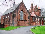 Upload another image |
| Ellisland [de] | 200 Nithsdale Road | 15 December 1970 | NS5693863352 | 55°50′32″N 4°17′11″W / 55.842104°N 4.286266°W / 55.842104; -4.286266 (Ellisland [de]) | Alexander Thomson, 1871. | 33450 | Upload Photo |
| Castlehill (Glasgow) [de] | 202 Nithsdale Road | 15 December 1970 | NS5689263367 | 55°50′32″N 4°17′13″W / 55.842225°N 4.287007°W / 55.842225; -4.287007 (Castlehill (Glasgow) [de]) | Alexander Thomson, 1870. | 33451 | Upload Photo |
| Pollok House | 2060 Pollokshaws Road | 6 July 1966 | NS5490761802 | 55°49′39″N 4°19′04″W / 55.827582°N 4.317843°W / 55.827582; -4.317843 (Pollok House) | Possibly Allan Dreghorn. Dated 1752. | 33455 |  Upload another image |
| Bridge over White Cart Water at Pollok House | 2060 Pollokshaws Road | 6 July 1966 | NS5488661731 | 55°49′37″N 4°19′05″W / 55.826939°N 4.31814°W / 55.826939; -4.31814 (Bridge over White Cart Water at Pollok House) | Built 1757-8. | 33456 |  Upload another image |
| Stables of Pollok House | 2060 Pollokshaws Road | 6 July 1966 | NS5499461661 | 55°49′35″N 4°18′59″W / 55.826343°N 4.31638°W / 55.826343; -4.31638 (Stables of Pollok House) | Mainly 17th-19th century; formerly stables to Pollok house, but at site of previous house (the Laighe Castle) and containing much re-used 17th century work. Fragments at E corner said to be of c. 1536 tower. | 33457 | 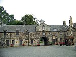 Upload another image |
| Benefrey [de] | 124 Springkell Avenue | 15 December 1970 | NS5577763054 | 55°50′21″N 4°18′17″W / 55.839083°N 4.304632°W / 55.839083; -4.304632 (Benefrey [de]) | W Hunter McNab, 1910. | 33486 | ![Benefrey [de]](http://upload.wikimedia.org/wikipedia/commons/thumb/d/db/124_Springkell_Avenue.jpg/150px-124_Springkell_Avenue.jpg) Upload another image |
| Former Caledonia Road Church | 1 Caledonia Road | 6 July 1966 | NS5893263851 | 55°50′50″N 4°15′17″W / 55.847172°N 4.254709°W / 55.847172; -4.254709 (Former Caledonia Road Church) | Alexander Thomson, 1856. | 33497 |  Upload another image |
| 40-61 (Inclusive) Carlton Place [de] and 16 Nicholson Street | 15 December 1970 | NS5891664582 | 55°51′13″N 4°15′19″W / 55.85373°N 4.255344°W / 55.85373; -4.255344 (40-61 (Inclusive) Carlton Place [de] and 16 Nicholson Street) | Peter Nicholson, 1802-4. No 50-53, Laurieston House has exceptional plaster work with columns, pilasters, swags and cherubs in vestibule and stair well. | 33499 | ![40-61 (Inclusive) Carlton Place [de] and 16 Nicholson Street](http://upload.wikimedia.org/wikipedia/commons/thumb/1/1a/Carlton_Place%2C_Glasgow%2C_Scotland.jpg/150px-Carlton_Place%2C_Glasgow%2C_Scotland.jpg) Upload another image | |
| Former Eglinton Engine Works [de] | 27-117 (Odd Nos) Cook Street (Westbridge Gardens) and 181 and 183 West Street | 17 June 1986 | NS5830664278 | 55°51′03″N 4°15′54″W / 55.850822°N 4.264922°W / 55.850822; -4.264922 (Former Eglinton Engine Works [de]) | Built from circa 1855. | 33504 | ![Former Eglinton Engine Works [de]](http://upload.wikimedia.org/wikipedia/commons/thumb/b/bb/Former_Eglinton_Engine_Works.jpg/150px-Former_Eglinton_Engine_Works.jpg) Upload another image |
| 162–170 Gorbals Street [de] | 15 December 1970 | NS5896764171 | 55°51′00″N 4°15′16″W / 55.850055°N 4.254317°W / 55.850055; -4.254317 (162–170 Gorbals Street [de]) | James Salmon, Jr. 1900. Former British Linen Bank, shop and flats with Glasgow style detailing. | 33513 | ![162–170 Gorbals Street [de]](http://upload.wikimedia.org/wikipedia/commons/thumb/4/4e/162-170_%28Even_Nos%29_Gorbals_Street.jpg/112px-162-170_%28Even_Nos%29_Gorbals_Street.jpg) Upload another image | |
| Scotland Street School | 225 Scotland Street | 6 July 1966 | NS5775264142 | 55°50′58″N 4°16′25″W / 55.849438°N 4.273692°W / 55.849438; -4.273692 (Scotland Street School) | Charles Rennie Mackintosh between 1903 and 1907. | 33534 |  Upload another image |
| Craigie Hall [de] | 6 Rowan Road, Dumbreck | 27 April 1978 | NS5554463935 | 55°50′49″N 4°18′32″W / 55.846923°N 4.308818°W / 55.846923; -4.308818 (Craigie Hall [de]) | John Honeyman, 1872. Added to during the 1890s by his architectural partners John Keppie and Charles Rennie Mackintosh. | 33583 | ![Craigie Hall [de]](http://upload.wikimedia.org/wikipedia/commons/thumb/4/4e/Craigie_Hall%2C_Dumbreck%2C_Glasgow_%28geograph_2179733%29.jpg/150px-Craigie_Hall%2C_Dumbreck%2C_Glasgow_%28geograph_2179733%29.jpg) Upload another image |
| Leverndale Hospital, Towerview Unit [de] | 510 Crookston Road | 15 December 1970 | NS5162462691 | 55°50′04″N 4°22′14″W / 55.834565°N 4.370688°W / 55.834565; -4.370688 (Leverndale Hospital, Towerview Unit [de]) | Malcolm Stark and Rowntree, 1890-5. Additions by D Barclay, 1903. | 33597 | ![Leverndale Hospital, Towerview Unit [de]](http://upload.wikimedia.org/wikipedia/commons/thumb/5/50/Tower_at_Leverndale_Hospital_-_geograph.org.uk_-_87401.jpg/112px-Tower_at_Leverndale_Hospital_-_geograph.org.uk_-_87401.jpg) Upload another image |
| Former Springburn College [de] | 110-136 (Even Nos) Flemington Street | 29 January 1990 | NS6056967426 | 55°52′47″N 4°13′50″W / 55.879745°N 4.230424°W / 55.879745; -4.230424 (Former Springburn College [de]) | James Miller, 1903-9. | 33612 | ![Former Springburn College [de]](http://upload.wikimedia.org/wikipedia/commons/thumb/d/d7/North_Glasgow_College_-_geograph.org.uk_-_559277.jpg/150px-North_Glasgow_College_-_geograph.org.uk_-_559277.jpg) Upload another image |
| Tollcross House [de] | 591 Tollcross Road | 15 December 1970 | NS6361963607 | 55°50′47″N 4°10′47″W / 55.84633°N 4.179787°W / 55.84633; -4.179787 (Tollcross House [de]) | David Bryce, 1848. | 33648 | ![Tollcross House [de]](http://upload.wikimedia.org/wikipedia/commons/thumb/9/97/Tollcross_House_-_geograph.org.uk_-_946123.jpg/150px-Tollcross_House_-_geograph.org.uk_-_946123.jpg) Upload another image |
| Daldowie Dovecot | Hamilton Road | 12 January 1971 | NS6677762899 | 55°50′27″N 4°07′45″W / 55.840856°N 4.129041°W / 55.840856; -4.129041 (Daldowie Dovecot) | Mid 18th century cylindrical dovecot. | 33668 |  Upload another image |
| Southern Necropolis Lodge | 316 Caledonia Road, Rutherglen Road | 15 December 1970 | NS5951163475 | 55°50′38″N 4°14′43″W / 55.843965°N 4.245274°W / 55.843965; -4.245274 (Southern Necropolis Lodge) | Charles Wilson, 1848. The main cemetery is Category B. | 33685 |  Upload another image |
| St Francis Church and Presbytery [de] | 405, 407 Cumberland Street | 15 December 1970 | NS5949363749 | 55°50′47″N 4°14′45″W / 55.84642°N 4.245703°W / 55.84642; -4.245703 (St Francis Church and Presbytery [de]) | Gilbert Blount, 1868; rebuilt by Pugin & Pugin 1878-81, chancel and chapels completed 1895. | 33690 | ![St Francis Church and Presbytery [de]](http://upload.wikimedia.org/wikipedia/commons/thumb/2/25/St_Francis%27_RC_Church%2C_Hutchesontown_-_geograph.org.uk_-_1167971.jpg/150px-St_Francis%27_RC_Church%2C_Hutchesontown_-_geograph.org.uk_-_1167971.jpg) Upload another image |
| St Andrews Suspension Bridge [de] | Adelphi Street/Glasgow Green | 23 March 1992 | NS5995964001 | 55°50′56″N 4°14′18″W / 55.848818°N 4.238397°W / 55.848818; -4.238397 (St Andrews Suspension Bridge [de]) | Neil Robson and Charles O'Neill, 1853-5. | 33692 | ![St Andrews Suspension Bridge [de]](http://upload.wikimedia.org/wikipedia/commons/thumb/c/c5/St._Andrew%27s_Suspension_Bridge_-_geograph.org.uk_-_1079756.jpg/150px-St._Andrew%27s_Suspension_Bridge_-_geograph.org.uk_-_1079756.jpg) Upload another image |
| Sentinel Works [de] | 61 Jessie Street, Polmadie | 13 May 1991 | NS5966662502 | 55°50′07″N 4°14′32″W / 55.835275°N 4.242298°W / 55.835275; -4.242298 (Sentinel Works [de]) | Archibald Leitch, engineer with Brand and Lithgow, architects, 1903-1904. Earliest reinforced concrete (ferro concrete) building in Scotland.[18] | 33693 | ![Sentinel Works [de]](http://upload.wikimedia.org/wikipedia/commons/thumb/f/fa/Sentinel_Works.jpg/150px-Sentinel_Works.jpg) Upload another image |
| Aikenhead House [de] | 325 Carmunnock Road, King's Park | 15 December 1970 | NS5964060268 | 55°48′55″N 4°14′30″W / 55.81521°N 4.241558°W / 55.81521; -4.241558 (Aikenhead House [de]) | 1806, 1823 flanking wings and alterations all probably by David Hamilton. | 33708 | ![Aikenhead House [de]](http://upload.wikimedia.org/wikipedia/commons/thumb/1/1d/Aikenhead_House%2C_King%27s_Park%2C_Glasgow_-_geograph.org.uk_-_678280.jpg/150px-Aikenhead_House%2C_King%27s_Park%2C_Glasgow_-_geograph.org.uk_-_678280.jpg) Upload another image |
| Ruchill Hospital, Water Tower | 520 Bilsland Drive | 6 April 1992 | NS5838568292 | 55°53′13″N 4°15′57″W / 55.886882°N 4.265759°W / 55.886882; -4.265759 (Ruchill Hospital, Water Tower) | Alexander Beith McDonald, 1892. | 33750 | 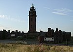 Upload another image |
| Kelvin Stevenson Memorial Church | 62 Belmont Street, 93 and 99 Garriochmill Road | 15 December 1970 | NS5753367233 | 55°52′38″N 4°16′44″W / 55.877123°N 4.278812°W / 55.877123; -4.278812 (Kelvin Stevenson Memorial Church) | John James Stevenson, 1898-1902. Church of Scotland. | 33753 |  Upload another image |
| Queens Cross Church and Hall | 870 Garscube Road | 6 July 1966 | NS5797667572 | 55°52′49″N 4°16′19″W / 55.880298°N 4.271915°W / 55.880298; -4.271915 (Queens Cross Church and Hall) | Charles Rennie Mackintosh, 1896-99. | 33764 |  Upload another image |
| St Columba of Iona Roman Catholic Church [de] and Presbytery | 74 and 76 Hopehill Road | 6 April 1992 | NS5829567132 | 55°52′35″N 4°16′00″W / 55.876441°N 4.26659°W / 55.876441; -4.26659 (St Columba of Iona Roman Catholic Church [de] and Presbytery) | 1937, Gillespie, Kidd & Coia. | 33765 | ![St Columba of Iona Roman Catholic Church [de] and Presbytery](http://upload.wikimedia.org/wikipedia/commons/thumb/b/ba/St_Columba%27s_RC_Church_-_geograph.org.uk_-_1177803.jpg/150px-St_Columba%27s_RC_Church_-_geograph.org.uk_-_1177803.jpg) Upload another image |
| Former St George’s In the Fields [de] | 485 St George's Road | 6 July 1966 | NS5845866865 | 55°52′27″N 4°15′50″W / 55.874092°N 4.263847°W / 55.874092; -4.263847 (Former St George’s In the Fields [de]) | 1885-6. H and D Barclay. | 33782 | ![Former St George’s In the Fields [de]](http://upload.wikimedia.org/wikipedia/commons/thumb/9/99/St_George%27s_In_The_Fields_-_geograph.org.uk_-_1177828.jpg/150px-St_George%27s_In_The_Fields_-_geograph.org.uk_-_1177828.jpg) Upload another image |
| St Mary's Roman Catholic Church | 99 Abercromby Street | 16 March 1993 | NS6070064541 | 55°51′14″N 4°13′37″W / 55.853881°N 4.226849°W / 55.853881; -4.226849 (St Mary's Roman Catholic Church) | Goldie and Child, 1841-2. | 33810 | 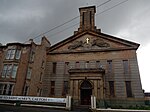 Upload another image |
| 105–169 Bell Street [de] | 22 March 1977 | NS5976064987 | 55°51′27″N 4°14′31″W / 55.857612°N 4.242083°W / 55.857612; -4.242083 (105–169 Bell Street [de]) | Built 1882. | 33814 | ![105–169 Bell Street [de]](http://upload.wikimedia.org/wikipedia/commons/thumb/8/85/105-169_%28Odd_Nos%29_Bell_Street.jpg/150px-105-169_%28Odd_Nos%29_Bell_Street.jpg) Upload another image | |
| Shelter ("Brigton Umbrella" [de]) | Bridgeton Cross | 16 March 1993 | NS6070963997 | 55°50′56″N 4°13′35″W / 55.848999°N 4.226426°W / 55.848999; -4.226426 (Shelter ("Brigton Umbrella" [de])) | 1874. | 33818 | ![Shelter ("Brigton Umbrella" [de])](http://upload.wikimedia.org/wikipedia/commons/thumb/9/95/Bridgeton_Cross_-_geograph.org.uk_-_1079913.jpg/150px-Bridgeton_Cross_-_geograph.org.uk_-_1079913.jpg) Upload another image |
| Alexander's School | 94 Duke Street | 15 December 1970 | NS6018265190 | 55°51′34″N 4°14′08″W / 55.859557°N 4.235451°W / 55.859557; -4.235451 (Alexander's School) | John Burnet Sr., 1858. Previously used as an annex by St Mungo's Academy. Currently housing small businesses. | 33827 |  Upload another image |
| The Doulton Fountain [de] | Glasgow Green | 15 December 1970 | NS6010564314 | 55°51′06″N 4°14′10″W / 55.85167°N 4.236229°W / 55.85167; -4.236229 (The Doulton Fountain [de]) | A E Pearce, 1888. | 33836 | ![The Doulton Fountain [de]](http://upload.wikimedia.org/wikipedia/commons/thumb/b/ba/Doulton_Fountain_-_Glasgow_Green.jpg/150px-Doulton_Fountain_-_Glasgow_Green.jpg) Upload another image |
| Nelson Monument | Glasgow Green | 15 December 1970 | NS5982464302 | 55°51′05″N 4°14′27″W / 55.851481°N 4.240707°W / 55.851481; -4.240707 (Nelson Monument) | David Hamilton, 1806. | 33837 | 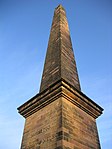 Upload another image |
| People's Palace | Glasgow Green | 15 December 1970 | NS6002964265 | 55°51′04″N 4°14′15″W / 55.851208°N 4.237416°W / 55.851208; -4.237416 (People's Palace) | A B MacDonald, City Engineer, 1894-8. | 33838 | 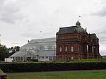 Upload another image |
| Mercat Building [de] | 15-23 (Odd Nos) London Road and 26 Gallowgate | 15 December 1970 | NS5969064845 | 55°51′23″N 4°14′35″W / 55.856317°N 4.243127°W / 55.856317; -4.243127 (Mercat Building [de]) | A Graham Henderson, 1928-1933. | 33851 | ![Mercat Building [de]](http://upload.wikimedia.org/wikipedia/commons/thumb/2/22/Mercat_Building_-_geograph.org.uk_-_939898.jpg/150px-Mercat_Building_-_geograph.org.uk_-_939898.jpg) Upload another image |
| Church of The Sacred Heart [de] | 50-56 (Even Nos) Old Dalmarnock Road | 15 December 1970 | NS6089863678 | 55°50′46″N 4°13′24″W / 55.84619°N 4.223246°W / 55.84619; -4.223246 (Church of The Sacred Heart [de]) | C J Menart, 1909-10; Presbytery, 1890 by Pugin & Pugin; later alterations by Gillespie, Kidd & Coia, 1953-4 including fresco restoration by William Crosbie. | 33855 | ![Church of The Sacred Heart [de]](http://upload.wikimedia.org/wikipedia/commons/thumb/2/2e/Sacredheartbridgeton.jpg/112px-Sacredheartbridgeton.jpg) Upload another image |
| Templeton Carpet Factory | 62 Templeton Street | 6 July 1966 | NS6032564163 | 55°51′01″N 4°13′58″W / 55.850378°N 4.23264°W / 55.850378; -4.23264 (Templeton Carpet Factory) | William Leiper, 1889. | 33857 |  Upload another image |
| Provan Hall | Auchinlea Park, Easterhouse | 15 December 1970 | NS6675566324 | 55°52′18″N 4°07′52″W / 55.871601°N 4.131076°W / 55.871601; -4.131076 (Provan Hall) | House possibly of late medieval origin, retaining a significant amount of early fabric. | 33863 |  Upload another image |
| Gartloch Hospital | Gartloch Road | 14 June 1991 | NS6835967134 | 55°52′46″N 4°06′21″W / 55.879315°N 4.105854°W / 55.879315; -4.105854 (Gartloch Hospital) | Thomson and Sandilands, 1889. | 33868 |  Upload another image |
| Walmer Crescent | Cessnock | 6 July 1966 | NS5632364465 | 55°51′07″N 4°17′48″W / 55.851914°N 4.296668°W / 55.851914; -4.296668 (Walmer Crescent) | Alexander Thomson, 1857-62. | 33876 | 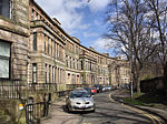 Upload another image |
| St Andrew’s East Church [de] | 681 Alexandra Parade and 6 Easter Craigs | 15 December 1970 | NS6187565529 | 55°51′47″N 4°12′31″W / 55.863089°N 4.208598°W / 55.863089; -4.208598 (St Andrew’s East Church [de]) | James Miller, 1903. | 33879 | ![St Andrew’s East Church [de]](http://upload.wikimedia.org/wikipedia/commons/thumb/5/52/St_Andrews_East_Church.jpg/150px-St_Andrews_East_Church.jpg) Upload another image |
| Cast-iron Fountain (Saracen Fountain) | Alexandra Park | 17 June 1992 | NS6190065687 | 55°51′52″N 4°12′30″W / 55.864515°N 4.208279°W / 55.864515; -4.208279 (Cast-iron Fountain (Saracen Fountain)) | Walter Macfarlane & Co, Saracen Foundry, originally for 1901 Glasgow Empire Exhibition. | 33880 |  Upload another image |
| The Necropolis | Cathedral Square | 15 December 1970 | NS6048265549 | 55°51′46″N 4°13′51″W / 55.862868°N 4.230847°W / 55.862868; -4.230847 (The Necropolis) | Opened May 1833. | 33890 | 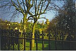 Upload another image |
| Our Lady of Good Counsel Church | 73 Craigpark | 23 September 1994 | NS6101065499 | 55°51′45″N 4°13′21″W / 55.862571°N 4.222392°W / 55.862571; -4.222392 (Our Lady of Good Counsel Church) | 1964-5, Gillespie, Kidd & Coia. | 33891 |  Upload another image |
| 176 Duke Street, Kirkhaven [de] | 15 December 1970 | NS6052765091 | 55°51′32″N 4°13′48″W / 55.858769°N 4.229893°W / 55.858769; -4.229893 (176 Duke Street, Kirkhaven [de]) | Peddie and Kinnear, 1857-8. | 33899 | ![176 Duke Street, Kirkhaven [de]](http://upload.wikimedia.org/wikipedia/commons/thumb/a/a0/176_Duke_Street%2C_Kirkhaven.jpg/150px-176_Duke_Street%2C_Kirkhaven.jpg) Upload another image | |
| St Anne's Church and Presbytery [de] | 17-23 (Odd Nos) Whitevale Street | 27 November 1979 | NS6139464936 | 55°51′27″N 4°12′58″W / 55.857627°N 4.215974°W / 55.857627; -4.215974 (St Anne's Church and Presbytery [de]) | Jack Coia of Gillespie, Kidd & Coia, 1931-3. | 33912 | ![St Anne's Church and Presbytery [de]](http://upload.wikimedia.org/wikipedia/commons/thumb/c/c3/St_Anne%27s_Church_and_Presbytery.jpg/150px-St_Anne%27s_Church_and_Presbytery.jpg) Upload another image |
| 52–54 Langside Drive [de] | 19 March 1991 | NS5731560342 | 55°48′55″N 4°16′43″W / 55.815193°N 4.278669°W / 55.815193; -4.278669 (52–54 Langside Drive [de]) | Late 19th century villa. Listed for its exceptional, near intact Glasgow Style interior. | 33936 | Upload Photo | |
| Former Waverley Cinema [de] | 18 Moss-Side Road | 17 June 1992 | NS5718062130 | 55°49′52″N 4°16′54″W / 55.831205°N 4.281761°W / 55.831205; -4.281761 (Former Waverley Cinema [de]) | Watson, Salmond and Gray, 1922. | 33941 | ![Former Waverley Cinema [de]](http://upload.wikimedia.org/wikipedia/commons/thumb/3/34/Old_Cinema%2C_Moss_Side_Road%2C_Shawlands_-_geograph.org.uk_-_926591.jpg/150px-Old_Cinema%2C_Moss_Side_Road%2C_Shawlands_-_geograph.org.uk_-_926591.jpg) Upload another image |
| Holmwood House | 61, 63 Netherlee Road | 17 June 1967 | NS5850559695 | 55°48′35″N 4°15′34″W / 55.809734°N 4.259358°W / 55.809734; -4.259358 (Holmwood House) | Alexander Thomson, 1857-59. | 33944 |  Upload another image |
| Pollokshaws Burgh Hall | 2025 Pollokshaws Road | 15 December 1970 | NS5612561514 | 55°49′31″N 4°17′54″W / 55.825362°N 4.298264°W / 55.825362; -4.298264 (Pollokshaws Burgh Hall) | Robert Rowand Anderson, 1895-8. | 33953 |  Upload another image |
| Anniesland Court | 833-861 (Odd Nos) Crow Road, Anniesland | 2 April 1996 | NS5467368865 | 55°53′27″N 4°19′31″W / 55.89092°N 4.325361°W / 55.89092; -4.325361 (Anniesland Court) | Jack Holmes and Partners, 1966-8. | 43034 | 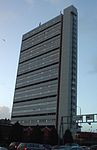 Upload another image |
| St Andrew's East Church Hall | 685 Alexandra Parade | 15 December 1970 | NS6189565518 | 55°51′47″N 4°12′30″W / 55.862996°N 4.208273°W / 55.862996; -4.208273 (St Andrew's East Church Hall) | James Salmon Junior and J Gaff Gillespie, 1899. | 48569 |  Upload another image |
| Scottish Ambulance Service station and St Andrew’s House [de], St Andrew's Ambulance Association | 30 Maitland Street and 54 Milton Street | 7 February 2005 | NS5888166138 | 55°52′04″N 4°15′24″W / 55.867689°N 4.256713°W / 55.867689; -4.256713 (Scottish Ambulance Service station and St Andrew’s House [de], St Andrew's Ambulance Association) | Begun Skinner, Bailey & Lubetkin, followed by Bailey and Robb, circa 1966-70. | 50073 | ![Scottish Ambulance Service station and St Andrew’s House [de], St Andrew's Ambulance Association](http://upload.wikimedia.org/wikipedia/commons/thumb/e/e9/St_Andrew%27s_House_DSCN1882.jpg/150px-St_Andrew%27s_House_DSCN1882.jpg) Upload another image |
| Burrell Collection | 2060 Pollokshaws Road, Pollok Country Park | 23 January 2013 | NS5548662138 | 55°49′51″N 4°18′27″W / 55.830833°N 4.3075°W / 55.830833; -4.3075 (Burrell Collection) | Barry Gasson Architects (firm), 1971-1983. | 52002 | 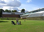 Upload another image |
See also
Wikimedia Commons has media related to Category A listed buildings in Glasgow.
Notes
- ^ Sometimes known as OSGB36, the grid reference (where provided) is based on the British national grid reference system used by the Ordnance Survey.
• "Guide to National Grid". Ordnance Survey. Retrieved 12 December 2007.
• "Get-a-map". Ordnance Survey. Retrieved 17 December 2007. - ^ Historic Environment Scotland assign a unique alphanumeric identifier to each designated site in Scotland, for listed buildings this always begins with "LB", for example "LB12345".
References
- ^ Guide to the Protection of Scotland's Listed Buildings (PDF). Historic Scotland. 2009. p. 4. ISBN 978-1-84917-013-0. Retrieved 5 May 2010.
- ^ "What is Listing?". Historic Scotland. Retrieved 5 May 2010.
- ^ a b Scottish Historic Environment Policy (PDF). Historic Scotland. October 2008. pp. 24–25. ISBN 978-1-84917-002-4. Retrieved 5 May 2010.
- ^ Guide to the Protection of Scotland's Listed Buildings, p. 17.
- ^ Dan Cruickshank, A Guide to the Georgian Buildings of Britain & Ireland, George Weidenfeld and Nicolson Ltd, 1985, pp.210-211.
- ^ A. Gomme, D. Walker, Architecture of Glasgow, Lund Humphries, 1968, p.92
- ^ F Wordsall, The City That Disappeared: Glasgow's Demolished Architecture, Richard Drew, 1981, p.11
- ^ Glasgow Central Conservation Area Appraisal, City Design Group, Development & Regeneration Services, Glasgow City Council, 2012, p.12
- ^ Glasgow Central Conservation Area Appraisal, City Design Group, Development & Regeneration Services, Glasgow City Council, 2012, p.23
- ^ See Gomme, Walker, 1968, pp.153-167
- ^ Williamson et al., 1990, p.11
- ^ F. Worsdall, Victorian City, Richard Drew, 1982, p.86
- ^ A. Gomme, D. Walker, Architecture of Glasgow, Lund Humphries, 1968, pp.19-39
- ^ George Fairfull Smith, "Lanarkshire House, Glasgow: The Evolution and Regeneration of a 'Merchant City' Landmark." Architectural History 42 (1999): pp.293-306.
- ^ A.M. Doak, D. Walker, Glasgow at a Glance : an Architectural Handbook, Collins, 1965, p.24, n.25
- ^ Doak, Walker, 1965, n.10
- ^ See N. Pevsner, Pioneers of Modern Design, Penguin, 1960, p.122.
- ^ John R. Hume, Industrial Archaeology of Glasgow, Blackie & Son, 1974, p.122
Bibliography
- William A. Brogden (ed), The Neo-classical Town: Scottish Contributions to Urban Design Since 1750, Rutland Press, 1996
- A.M. Doak, D. Walker, Glasgow at a Glance: an Architectural Handbook, Collins, 1965
- Glasgow Central Conservation Area Appraisal, City Design Group, Development & Regeneration Services, Glasgow City Council, 2012, (PDF)
- A. Gomme, D. Walker, Architecture of Glasgow, Lund Humphries, 1968
- Henry-Russell Hitchcock, Early Victorian Architecture in Britain, Yale, 1954
- John R. Hume, Industrial Archaeology of Glasgow, Blackie & Son, 1974
- Deborah Mays, The Architecture of Scottish Cities, Tuckwell Press, 2001
- Ronald McFadzean, Life and Work of Alexander Thomson, Routledge, 1979
- Charles McKean, Central Glasgow - an Illustrated Architectural Guide, Mainstream Publishing, 1989
- Ray McKenzie, Public Sculpture of Glasgow, Liverpool University Press, 2002
- Peter Reed, Glasgow: The Forming of The City, Edinburgh University Press, 1999
- Sam Small, Greater Glasgow: An Illustrated Architectural Guide, The Royal Incorporation of Architects in Scotland, 2008.
- Robin Ward, Exploring Glasgow: The Architectural Guide, Birlinn, 2017
- Elizabeth Williamson, Anne Riches, Malcolm Higgs, Buildings of Scotland: Glasgow, Yale, 1990
- F. Worsdall, Victorian City, Richard Drew, 1982
- Frank Worsdall, The Tenement: A Way of Life, Chambers, 1979
- v
- t
- e
- City of Aberdeen
- Aberdeenshire
- Angus
- Argyll and Bute
- Clackmannanshire
- Dumfries and Galloway
- City of Dundee
- East Ayrshire
- East Dunbartonshire
- East Lothian
- East Renfrewshire
- City of Edinburgh
- Falkirk
- Fife
- City of Glasgow
- Highland
- Inverclyde
- Midlothian
- Moray
- North Ayrshire
- North Lanarkshire
- Orkney
- Perth and Kinross
- Renfrewshire
- Scottish Borders
- Shetland
- South Ayrshire
- South Lanarkshire
- Stirling
- West Dunbartonshire
- West Lothian
- Western Isles (na h-Eileanan Siar)