List of World Heritage Sites in Guatemala


The United Nations Educational, Scientific and Cultural Organization (UNESCO) World Heritage Sites are places of importance to cultural or natural heritage as described in the UNESCO World Heritage Convention, established in 1972.[1] Guatemala accepted the convention on January 16, 1979, making its historical sites eligible for inclusion on the list. As of 2023, Guatemala has four World Heritage Sites, Takalik Abaj, the most recent was inscribed in 2023. [2]
Location of sites


Tikal National Park
Antigua Guatemala
Quiriguá
Takalik Abaj
class=notpageimage|
Location of World Heritage Sites in  Guatemala
List of sites
| Name | Image | Location | Criteria | Year | Description |
|---|---|---|---|---|---|
| Tikal National Park |  | Petén Department 17°13′19″N 89°37′25″W / 17.221944°N 89.623611°W / 17.221944; -89.623611 (Tikal National Park) | Mixed (i) (iii) (iv) (ix) (x) | 1979 | In the heart of the jungle, surrounded by lush vegetation, lies one of the major sites of Mayan civilization, inhabited from the 6th century B.C. to the 10th century A.D. The ceremonial centre contains superb temples and palaces, and public squares accessed by means of ramps. Remains of dwellings are scattered throughout the surrounding countryside.[3] |
| Antigua Guatemala |  | Sacatepéquez Department 14°33′27″N 90°44′00″W / 14.5575°N 90.733333°W / 14.5575; -90.733333 (Antigua Guatemala) | Cultural (ii) (iii) (iv) | 1979 | Antigua, the capital of the Captaincy-General of Guatemala, was founded in the early 16th century. Built 1,500 m above sea-level, in an earthquake-prone region, it was largely destroyed by an earthquake in 1773 but its principal monuments are still preserved as ruins. In the space of under three centuries the city, which was built on a grid pattern inspired by the Italian Renaissance, acquired a number of superb monuments.[4] |
| Archaeological Park and Ruins of Quirigua |  | Izabal Department 15°16′10″N 89°02′25″W / 15.269444°N 89.040278°W / 15.269444; -89.040278 (Archaeological Park and Ruins of Quirigua) | Cultural (i) (ii) (iv) | 1981 | Inhabited since the 2nd century A.D., Quirigua had become during the reign of Cauac Sky (723–84) the capital of an autonomous and prosperous state. The ruins of Quirigua contain some outstanding 8th-century monuments and an impressive series of carved stelae and sculpted calendars that constitute an essential source for the study of Mayan civilization.[5] |
| National Archaeological Park Tak’alik Ab’aj |  | Retalhuleu Department 14°38′45″N 91°44′10″W / 14.645833°N 91.736111°W / 14.645833; -91.736111 (National Archaeological Park Tak’alik Ab’aj) | Cultural (ii) (iii) | 2023 | Tak’alik Ab’aj is an archaeological site located on the Pacific Coast of Guatemala. Its 1,700-year history spans a period that saw the transition from the Olmec civilization to the emergence of Early Mayan culture. Tak’alik Ab’aj had a primary role in this transition, in part because it was vital to the long-distance trade route that connected the Isthmus of Tehuantepec in today's Mexico to present-day El Salvador. Ideas and customs were shared extensively along this route. Sacred spaces and buildings were laid out according to cosmological principles, and innovative water management systems, ceramics, and lapidary art can be found. Today, Indigenous groups of different affiliations still consider the site a sacred place and visit it to perform rituals.[6] |
Tentative List
| Site | Image | Location | Criteria | Area ha (acre) | Year of submission | Description |
|---|---|---|---|---|---|---|
| The Cultural Triangle |  | Petén Department 17°06′54″N 89°23′02″W / 17.115°N 89.384°W / 17.115; -89.384 (The Cultural Triangle) | Mixed | 2002 | [7] | |
| The Cuenca Mirador |  | Petén Department 17°45′18″N 89°55′14″W / 17.755°N 89.920556°W / 17.755; -89.920556 (The Cuenca Mirador) | Mixed | 2002 | [8] | |
| The Core of the Mayan Area |  | Petén Department 17°25′48″N 90°53′26″W / 17.43°N 90.890556°W / 17.43; -90.890556 (The Core of the Mayan Area) | Mixed | 2002 | [9] | |
| The Route of The Rivers |  | Petén Department 16°00′00″N 90°32′35″W / 16°N 90.542942°W / 16; -90.542942 (The Route of The Rivers) | Mixed | 2002 | [10] | |
| Naj Tunich Cave |  | Petén Department 16°16′32″N 89°16′32″W / 16.275556°N 89.275592°W / 16.275556; -89.275592 (Naj Tunich Cave) | Mixed | 2002 | [11] | |
| The Mayan-Olmecan Encounter | 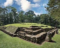 | Retalhuleu Department 4°38′45″N 91°44′10″W / 4.645833°N 91.736111°W / 4.645833; -91.736111 (The Mayan-Olmecan Encounter) | Mixed | 2002 | [12] | |
| Route of the Franciscan Evangelisation |  | Cultural (i) (iv) (v) (vi) | 2002 | [13] | ||
| Route of the Dominique Evangelisation |  | Cultural (i) (iv) (v) (vi) | 2002 | [14] | ||
| Route of the Peace and National Identity |  | Cultural (iv) (vi) | 2002 | [15] | ||
| Castle of San Felipe de Lara |  | Izabal Department 15°38′15″N 88°59′36″W / 15.63742°N 88.99338°W / 15.63742; -88.99338 (Castle of San Felipe de Lara) | Cultural (iv) | 2002 | [16] | |
| Route of the Agroindustry and the Architecture Victoriana | Cultural (iv) | 2002 | [17] | |||
| Town of Chichicastenango |  | El Quiché Department 14°56′00″N 91°07′00″W / 14.933333°N 91.116667°W / 14.933333; -91.116667 (Town of Chichicastenango) | Cultural (v) (vi) | 2002 | [18] | |
| The Green Route of Verapaz, Guatemala |  | Alta Verapaz Department 15°55′00″N 90°40′00″W / 15.916667°N 90.666667°W / 15.916667; -90.666667 (The Green Route of Verapaz, Guatemala) | Natural (vii) | 2002 | [19] | |
| Sierra De Las Minas Biosphere Reservation |  | Alta Verapaz Department, Baja Verapaz Department, El Progreso Department, Izabal Department, Zacapa Department 15°10′00″N 89°40′00″W / 15.16667°N 89.66667°W / 15.16667; -89.66667 (Sierra De Las Minas Biosphere Reservation) | Natural (vii) (viii) (ix) (x) | 2002 | [20] | |
| National Park Sierra del Lacandón |  | Petén Department 17°11′42″N 91°05′10″W / 17.195086°N 91.086103°W / 17.195086; -91.086103 (National Park Sierra del Lacandón) | Mixed | 2002 | [21] | |
| The Manglares Route of Pacific Coast of Guatemala |  | Escuintla Department, Jutiapa Department, Retalhuleu Department, San Marcos Department, Santa Rosa Department, Suchitepéquez Department 14°28′47″N 92°07′23″W / 14.479722°N 92.123056°W / 14.479722; -92.123056 (The Manglares Route of Pacific Coast of Guatemala) | Natural (vii) | 2002 | [22] | |
| Protected area of Lake Atitlán: multiple use |  | Sololá Department 14°42′N 91°12′W / 14.7°N 91.2°W / 14.7; -91.2 (Protected area of Lake Atitlán: multiple use) | Natural (vii) (viii) (ix) | 2002 | [23] | |
| Visis Cabá National park and Triangulo Ixil Vernacular Architecture |  | El Quiché Department 15°34′26″N 90°59′46″W / 15.574°N 90.996°W / 15.574; -90.996 (Visis Cabá National park and Triangulo Ixil Vernacular Architecture) | Mixed | 2002 | [24] | |
| The Painted Murals of San Bartolo |  | Petén Department 17°33′06″N 89°24′32″W / 17.55167°N 89.40889°W / 17.55167; -89.40889 (The Painted Murals of San Bartolo) | Cultural (i) (ii) | 2012 | [25] | |
| The Caves of Naj Tunich |  | Petén Department 16°16′32″N 89°16′32″W / 16.275556°N 89.275592°W / 16.275556; -89.275592 (The Caves of Naj Tunich) | Cultural (i) (iii) (v) (vi) (vii) | 2012 | [26] | |
| Archeological Site Naranjo Sa’aal |  | Petén Department 17°08′01″N 89°15′44″W / 17.133597°N 89.262169°W / 17.133597; -89.262169 (Archeological Site Naranjo Sa’aal) | Cultural (ii) (iv) (vi) | 2022 | [27] | |
| National Theater of Guatemala |  | Guatemala Department 14°37′38″N 90°31′04″W / 14.627089°N 90.517842°W / 14.627089; -90.517842 (National Theater of Guatemala) | Cultural (i) (iv) | 2022 | [28] |
References
- ^ "The World Heritage Convention". UNESCO. Retrieved January 8, 2024.
- ^ "Guatemala". UNESCO. Retrieved January 8, 2024.
- ^ "Tikal National Park". UNESCO World Heritage Centre. Retrieved 2023-11-20.
 Text was copied from this source, which is available under a Creative Commons Attribution 3.0 IGO (CC BY 3.0 IGO) license.
 - ^ "Antigua Guatemala". UNESCO World Heritage Centre. Retrieved 2023-11-20. Text was copied from this source, which is available under a Creative Commons Attribution 3.0 IGO (CC BY 3.0 IGO) license.
- ^ "Archaeological Park and Ruins of Quirigua". UNESCO World Heritage Centre. Retrieved 2023-11-20. Text was copied from this source, which is available under a Creative Commons Attribution 3.0 IGO (CC BY 3.0 IGO) license.
- ^ "National Archaeological Park Tak'alik Ab'aj". UNESCO World Heritage Centre. Retrieved 2023-11-20. Text was copied from this source, which is available under a Creative Commons Attribution 3.0 IGO (CC BY 3.0 IGO) license.
- ^ "The Cultural Triangle". UNESCO World Heritage Centre. Retrieved 2024-01-08.
- ^ "The Cuenca Mirador". UNESCO World Heritage Centre. Retrieved 2024-01-08.
- ^ "The Core of the Mayan Area". UNESCO World Heritage Centre. Retrieved 2024-01-08.
- ^ "The Route of The Rivers". UNESCO World Heritage Centre. Retrieved 2024-01-08.
- ^ "Naj Tunich Cave". UNESCO World Heritage Centre. Retrieved 2024-01-08.
- ^ "The Mayan-Olmecan Encounter". UNESCO World Heritage Centre. Retrieved 2024-01-08.
- ^ "Route of the Franciscan Evangelisation". UNESCO World Heritage Centre. Retrieved 2024-01-08.
- ^ "Route of the Dominique Evangelisation". UNESCO World Heritage Centre. Retrieved 2024-01-08.
- ^ "Route of the Peace and National Identity". UNESCO World Heritage Centre. Retrieved 2024-01-08.
- ^ "Castle of San Felipe de Lara". UNESCO World Heritage Centre. Retrieved 2024-01-08.
- ^ "Route of the Agroindustry and the Architecture Victoriana". UNESCO World Heritage Centre. Retrieved 2024-01-08.
- ^ "Town of Chichicastenango". UNESCO World Heritage Centre. Retrieved 2024-01-08.
- ^ "The Green Route of Verapaz, Guatemala". UNESCO World Heritage Centre. Retrieved 2024-01-08.
- ^ "Sierra De Las Minas Biosphere Reservation". UNESCO World Heritage Centre. Retrieved 2024-01-08.
- ^ "National Park Sierra del Lacandón". UNESCO World Heritage Centre. Retrieved 2024-01-08.
- ^ "The Manglares Route of Pacific Coast of Guatemala". UNESCO World Heritage Centre. Retrieved 2024-01-08.
- ^ "Protected area of Lake Atitlán: multiple use". UNESCO World Heritage Centre. Retrieved 2024-01-08.
- ^ "Visis Cabá National park and Triangulo Ixil Vernacular Architecture". UNESCO World Heritage Centre. Retrieved 2024-01-08.
- ^ "The Painted Murals of San Bartolo". UNESCO World Heritage Centre. Retrieved 2024-01-08.
- ^ "The Caves of Naj Tunich". UNESCO World Heritage Centre. Retrieved 2024-01-08.
- ^ "Archeological Site Naranjo Sa'aal". UNESCO World Heritage Centre. Retrieved 2024-01-08.
- ^ "National Theater of Guatemala". UNESCO World Heritage Centre. Retrieved 2024-01-08.
- v
- t
- e
 World portal
| |||||
|---|---|---|---|---|---|
| History |   | ||||
| Geography |
| ||||
| Politics | |||||
| Economy | |||||
| Society |
| ||||
| |||||


