List of heritage sites of the Helderberg area
Sites recognised ny SAHRA
Map all coordinates using OpenStreetMap
Download coordinates as:
- KML
- GPX (all coordinates)
- GPX (primary coordinates)
- GPX (secondary coordinates)
This is a list of heritage sites in the Helderberg region of in the Western Cape, as recognized by the South African Heritage Resource Agency.[1]
| SAHRA identifier | Site name | Description | Town | District | NHRA status | Coordinates | Image |
|---|---|---|---|---|---|---|---|
| 9/2/083/0001 | Old Dutch Reformed Church, Church Street, Somerset West | The old Dutch Reformed Church in Somerset West is situated between Church and Victoria Streets, not far from the main street. The congregation of Hottentots Holland was established in 1819, three years before the town of Somerset West came into being. | Cape Town, Somerset West | Somerset West | Provincial Heritage Site | 34°05′12″S 18°50′47″E / 34.086737°S 18.84633°E / -34.086737; 18.84633 (SAHRA identifier 9/2/083/0001 - Old Dutch Reformed Church, Church Street, Somerset West) |  Type of site: Church Current use: Church. The Church was consecrated in 1820 by the Rev. Meent Borcherds of Stellenbosch and was restored in 1863 and 1963. It is proclaimed a monument on account of its history and its remarkable architecture |
| 9/2/083/0002 | Parel Vallei, Aberdeen Road, Somerset West | In the immediate vicinity of Somerset West lie a number of old historic farms with their Cape-Dutch homesteads which fill every lover of the Boland with nostalgia. One of these farms is Parel Vallei. Parel Vallei Road branches off the main road inside Som Architectural style: Cape Gabled, with significant layering. | Cape Town, Somerset West | Somerset West | Provincial Heritage Site | 34°04′02″S 18°51′19″E / 34.067124°S 18.855244°E / -34.067124; 18.855244 (SAHRA identifier 9/2/083/0002 - Parel Vallei, Aberdeen Road, Somerset West) |  Upload Photo |
| 9/2/083/0003 | Bridgewater Manor, Somerset West | Somerset West | Somerset West | 34°05′23″S 18°51′20″E / 34.089732°S 18.855490°E / -34.089732; 18.855490 (SAHRA identifier 9/2/083/0003 - Bridgewater Manor, Somerset West) | Upload Photo | ||
| 9/2/083/0004 | SOMERSET WEST MUNICIPAL AREA, GENERAL | Somerset West | Somerset West | Upload Photo | |||
| 9/2/083/0005 | Helderberg College Road: Avenue of Trees, Somerset West | Somerset West | Somerset West | 34°03′38″S 18°50′16″E / 34.060568°S 18.837649°E / -34.060568; 18.837649 (SAHRA identifier 9/2/083/0005 - Helderberg College Road: Avenue of Trees, Somerset West) | Upload Photo | ||
| 9/2/083/0006 | Morgenster, Lourens Road, Somerset West District | The house is H-shaped with 6 really perfect gables; the front gable (recently well rebuilt) is dated 1786 and shows the holbol style at its most beautiful, with convex edge mouldings continued onto the gable face and ending as fully developed scrolls, the nucleus of this farm consisted of the third of the 4 parts into which Vergelegen was divided after the recall of Willem Adriaan van der Stel; it was bought by Jacques Malan. Malan’s daughter Catharina married Willem Morkel of Onverwacht, and their son Architectural style: Cape Gabled. | Cape Town | Somerset West | Provincial Heritage Site | 34°04′42″S 18°52′01″E / 34.078434°S 18.866819°E / -34.078434; 18.866819 (SAHRA identifier 9/2/083/0006 - Morgenster, Lourens Road, Somerset West District) | Upload Photo |
| 9/2/083/0006/01 | Upper Morgenster, remainder of Farm 1319, Morgenster, Somerset West | Somerset West | Somerset West | 34°05′02″S 18°53′06″E / 34.083949°S 18.884953°E / -34.083949; 18.884953 (SAHRA identifier 9/2/083/0006/01 - Upper Morgenster, remainder of Farm 1319, Morgenster, Somerset West) | Upload Photo | ||
| 9/2/083/0007 | Gantouw Pass, Somerset West District | The occupation of the Hottentots Holland Valley by Willem Adriaan van der Stel halted the eastward expansion of the Colony for a time and it was only after his dismissal in 1707 that the trek over the Hottentots Holland Mountains began.
| Cape Town | Somerset West | Provincial Heritage Site | 34°08′21″S 18°56′25″E / 34.139184°S 18.940279°E / -34.139184; 18.940279 (SAHRA identifier 9/2/083/0007 - Gantouw Pass, Somerset West District) | 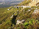 Type of site: Pass |
| 9/2/083/0008 | Voorburg, Victoria Street, Somerset West | Architectural style: Cape Gabled.
| Cape Town, Somerset West | Somerset West | Provincial Heritage Site | 34°05′25″S 18°50′20″E / 34.090319°S 18.838751°E / -34.090319; 18.838751 (SAHRA identifier 9/2/083/0008 - Voorburg, Victoria Street, Somerset West) | Upload Photo |
| 9/2/083/0009 | Zandvliet, Faure, Somerset West | Somerset West | Somerset West | Upload Photo | |||
| 9/2/083/0010 | Vergelegen, Somerset West | Somerset West | Somerset West | 34°04′38″S 18°51′43″E / 34.077178°S 18.861907°E / -34.077178; 18.861907 (SAHRA identifier 9/2/083/0010 - Vergelegen, Somerset West) |  | ||
| 9/2/083/0010/001 | Camphor trees, Vergelegen, Somerset West | The historical farm Vergelegen lies a few kilometres due east of Somerset West in an angle between the Hottentots Holland Mountains and the Helderberg. It was granted to Governor Willem Adriaan van der Stel by the visiting Commissioner Wouter Valckenier. | Cape Town, Somerset West | Somerset West | Provincial Heritage Site | 34°04′38″S 18°53′00″E / 34.077174°S 18.883349°E / -34.077174; 18.883349 (SAHRA identifier 9/2/083/0010/001 - Camphor trees, Vergelegen, Somerset West) | 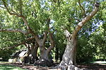 Type of site: Tree |
| 9/2/083/0011 | SIR LOWRY'S PASS VILLAGE, SOMERSET WEST DISTRICT, GENERAL | Somerset West | Somerset West |  | |||
| 9/2/083/0011/001 | Railway Station, Sir Lowry's Pass Village | Type of site: Railway Station.
| Cape Town, Sir Lowry's Pass Village | Somerset West | Provincial Heritage Site | 34°07′05″S 18°54′47″E / 34.118060°S 18.913060°E / -34.118060; 18.913060 (SAHRA identifier 9/2/083/0011/001 - Railway Station, Sir Lowry's Pass Village) | Upload Photo |
| 9/2/083/0011/003 | Sweet Safraan, Sir Lowry's Pass Village, Somerset West District | The original dwelling consisted of a central passage with two rooms leading off it on either side, making it a four room house with a thatched roof, At a later date two more rooms were built onto the right-hand side leading directly out of the original t The property on which this dwelling—house is situated, originally formed part of a freehold grant to C.F.Prenger from Cologne in 1779 and named Frederiksburg. It was subdivided in 1830 and this portion came in the possession of the widow J.C whose husband | Cape Town, Sir Lowry's Pass | Somerset West | Provincial Heritage Site | 34°07′08″S 18°54′33″E / 34.118866°S 18.909053°E / -34.118866; 18.909053 (SAHRA identifier 9/2/083/0011/003 - Sweet Safraan, Sir Lowry's Pass Village, Somerset West District) |  Type of site: Farmstead The original portion of this victorianised dwelling-house probably dates from the beginning of the nineteenth century. The house is situated on property which was originally granted to G. F. Prenger in 1779. |
| 9/2/083/0011/2 | Old Primary School, Sir Lowry's Pass Village, Somerset West District | Somerset West | Somerset West | 34°07′13″S 18°54′24″E / 34.120283°S 18.906679°E / -34.120283; 18.906679 (SAHRA identifier 9/2/083/0011/2 - Old Primary School, Sir Lowry's Pass Village, Somerset West District) | Upload Photo | ||
| 9/2/083/0012 | Predikants Square, Somerset West | Type of site: Public open space.
| Cape Town, Somerset West | Somerset West | Provincial Heritage Site | 34°05′03″S 18°50′29″E / 34.084130°S 18.841370°E / -34.084130; 18.841370 (SAHRA identifier 9/2/083/0012 - Predikants Square, Somerset West) |  Current use: Park. |
| 9/2/083/0013 | Old Dovecot, Farm 811, Overwacht (De Bosch/Die Bos), Somerset West District | Somerset West | Somerset West |  | |||
| 9/2/083/0013/001 | Old Dovecot, Onverwacht 811, Somerset West District | Type of site: Dovecote This dovecot is a particularly good example of the dovecots often built on old farms. | Cape Town | Somerset West | Provincial Heritage Site | 33°54′43″S 18°24′57″E / 33.911847°S 18.415972°E / -33.911847; 18.415972 (SAHRA identifier 9/2/083/0013/001 - Old Dovecot, Onverwacht 811, Somerset West District) | Upload Photo |
| 9/2/083/0014 | Dreamer's Tavern Coach Restaurant, 51 Victoria Road, Somerset West | Somerset West | Somerset West | 34°05′10″S 18°50′48″E / 34.086133°S 18.846557°E / -34.086133; 18.846557 (SAHRA identifier 9/2/083/0014 - Dreamer's Tavern Coach Restaurant, 51 Victoria Road, Somerset West) | Upload Photo | ||
| 9/2/083/0015 | Dennegeur, Somerset West | Somerset West | Somerset West | 34°05′49″S 18°52′08″E / 34.096887°S 18.868762°E / -34.096887; 18.868762 (SAHRA identifier 9/2/083/0015 - Dennegeur, Somerset West) | Upload Photo | ||
| 9/2/083/0016 | Old Lourens River Bridge, Main Street, Somerset West | This bridge, which is situated just where the main road to the Strand and Sir Lowry’s Pass leaves the town of Somerset West, marks an important event in the history of communications in South Africa.
| Cape Town, Somerset West | Somerset West | Provincial Heritage Site | 34°05′00″S 18°51′00″E / 34.083242°S 18.849986°E / -34.083242; 18.849986 (SAHRA identifier 9/2/083/0016 - Old Lourens River Bridge, Main Street, Somerset West) |  Type of site: Bridge. Current use: Bridge. |
| 9/2/083/0017 | Somerset House Preparatory School, Somerset West | The original purchaser of this property was Catherine, widow of Gerrit Cloete, who gave the farm the name of Cloetenberg. In 1725 Cloetenberg was transferred to C. Louw and his Deed of Transfer contains the first recorded reference to a house on the property | Cape Town, Somerset West | Somerset West | Provincial Heritage Site | 34°04′43″S 18°51′12″E / 34.078643°S 18.853400°E / -34.078643; 18.853400 (SAHRA identifier 9/2/083/0017 - Somerset House Preparatory School, Somerset West) | Upload Photo |
| 9/2/083/0018 | Land-en-Zeezicht, 15 Verster Avenue, Somerset West | The homestead on Land en-Zeezicht is H-shaped; its main gable, at the present back of the house, is dated 1834, and shows the signs of Its late date: the Inner pilasters are rather close together while the winged scrolls have grown out of proportion. The In 1893 it came into the possession of J. J. Hendriks, the nephew of D. Buissini of Erinvale. | Cape Town, Somerset West | Somerset West | Provincial Heritage Site | 34°04′19″S 18°52′32″E / 34.072070°S 18.875487°E / -34.072070; 18.875487 (SAHRA identifier 9/2/083/0018 - Land-en-Zeezicht, 15 Verster Avenue, Somerset West) | Upload Photo |
| 9/2/083/0019 | Erinvale, Lourensford Road, Somerset West | Somerset West | Somerset West | 34°04′24″S 18°53′18″E / 34.073252°S 18.888292°E / -34.073252; 18.888292 (SAHRA identifier 9/2/083/0019 - Erinvale, Lourensford Road, Somerset West) | Upload Photo | ||
| 9/2/083/0020 | Dwelling and watermill, Knorhoek, Somerset West District | This is a most unusual house in more than one aspect. According to the ground plan the house was originally H—shaped but was turned into a rectangle and covered by a roof with a ridge in front and three parallel ridges behind it running from back to front The farm Knorhoek was granted to David Malan in 1717 and was slightly over six morgen in extent. It was transferred, along with De Fortuin, to his son Jacques Malan in 1790, and a year later to François Joubert, who built the house in 1795. | Cape Town | Somerset West | Provincial Heritage Site | 33°55′30″S 18°25′27″E / 33.924869°S 18.424055°E / -33.924869; 18.424055 (SAHRA identifier 9/2/083/0020 - Dwelling and watermill, Knorhoek, Somerset West District) | Upload Photo |
| 9/2/083/0021 | Old Dutch Reformed Church Parsonage, 41 Lourens Street, Somerset West | This parsonage building, which was erected in 1819, was enlarged and rebuilt in true Victorian style in 1848 at the request of Dr J. F. Reitz after his appointment as minister to the congregation. Hereafter it served as parsonage until 1948. | Cape Town, Somerset West | Somerset West | Provincial Heritage Site | 34°05′18″S 18°50′51″E / 34.088305°S 18.847575°E / -34.088305; 18.847575 (SAHRA identifier 9/2/083/0021 - Old Dutch Reformed Church Parsonage, 41 Lourens Street, Somerset West) |  Type of site: Pastorie Previous use: Parsonage. Current use: Restaurant. |
| 9/2/083/0022 | Lourens Street, Somerset West | Somerset West | Somerset West | 34°05′23″S 18°50′39″E / 34.089695°S 18.844217°E / -34.089695; 18.844217 (SAHRA identifier 9/2/083/0022 - Lourens Street, Somerset West) | Upload Photo | ||
| 9/2/083/0023 | Police Station, 124 Main Street, Somerset West | This U-shaped building has a feature peculiar to Hottentots Holland; namely a front gable with small distinctive 'thumb wings' reduced to the width of the edge- mould only. The Police Station, originally a dwelling-house, probably dates from between 1835 Architectural style: Cape Gabled. | Cape Town, Somerset West | Somerset West | Provincial Heritage Site | 34°04′55″S 18°50′59″E / 34.081862°S 18.849703°E / -34.081862; 18.849703 (SAHRA identifier 9/2/083/0023 - Police Station, 124 Main Street, Somerset West) | 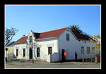 Type of site: Police Station. Current use: Police station. |
| 9/2/083/0024 | Magistrate's office, 126 Main Street, Somerset West | Architecturally the court are a fine example of the public building style at the turn of the century. The colonnaded front facade has two extending rooms and stoepkamers on either side. These extending facades have low triangular pediments with a rather a Somerset West became an assistant Magistracy under Stellenbosch in 1892 with Mr. J. St. Vincent Cripps as first assistant magistrate. In 1898 a courthouse building which also housed the post office was completed. Somerset West. by this time having become Architectural style: Edwardian. | Cape Town, Somerset West | Somerset West | Provincial Heritage Site | 34°04′55″S 18°50′59″E / 34.081857°S 18.849699°E / -34.081857; 18.849699 (SAHRA identifier 9/2/083/0024 - Magistrate's office, 126 Main Street, Somerset West) |  Type of site: Magistrates Office Previous use: Residence. Current use: Civic. This building was erected in 1898. It originally housed the post office, as well as the magistrate's court, after Somerset West was proclaimed an Assistant Magistracy in 1892. |
| 9/2/083/0025 | Standard Bank Building, Main Street, Somerset West | Somerset West | Somerset West | 34°05′08″S 18°51′10″E / 34.085576°S 18.852866°E / -34.085576; 18.852866 (SAHRA identifier 9/2/083/0025 - Standard Bank Building, Main Street, Somerset West) | Upload Photo | ||
| 9/2/083/0026 | Broadlands, Sir Lowry's Pass, Somerset West District | Somerset West | Somerset West | 34°07′25″S 18°52′28″E / 34.123501°S 18.874583°E / -34.123501; 18.874583 (SAHRA identifier 9/2/083/0026 - Broadlands, Sir Lowry's Pass, Somerset West District) | Upload Photo | ||
| 9/2/083/0027 | Quinan House, Somerset West District | Somerset West | Somerset West | Upload Photo | |||
| 9/2/083/0028 | Groot Paardevlei, Somerset West | On the outskirts of Somerset West the old Firgrove Road branches off the road to Stellenbosch. A couple of kilo- metres further on and to the right the large group of buildings belonging to the farm Groot Paardevlei is situated. | Cape Town, Somerset West | Somerset West | Provincial Heritage Site | 34°05′20″S 18°49′56″E / 34.088778°S 18.832240°E / -34.088778; 18.832240 (SAHRA identifier 9/2/083/0028 - Groot Paardevlei, Somerset West) | Upload Photo |
| 9/2/083/0029 | Vergenoegd, Faure, Somerset West District | The house is an incomplete H, with a missing right back wing; it is however evident that this wing once existed. The front gable is identical to one of the outbuildings' at Spier, and is a good example of a gable with a purely holbol outline with the edge One of the early owners, Lambert Myburgh is likely to have built this house or enlarged an existing house in about 1745. This farm had first been granted in 1696 to Pieter de Vos; After various transfers, it became the property of Johannes Nicolaas Colyn | Cape Town | Somerset West | Provincial Heritage Site | 34°02′05″S 18°44′21″E / 34.034606°S 18.739194°E / -34.034606; 18.739194 (SAHRA identifier 9/2/083/0029 - Vergenoegd, Faure, Somerset West District) |  Type of site: Farmstead The earliest section of this H-shape dwelling- house with its impressive gables probably dates from the middle of the 18th century. The farmyard is bounded by a ring-wall and an interesting complex of outbuildings |
| 9/2/083/0030 | The Old Cottage, 23 Andries Pretorius Street, Somerset West | Somerset West | Somerset West | 34°05′22″S 18°51′12″E / 34.089405°S 18.853233°E / -34.089405; 18.853233 (SAHRA identifier 9/2/083/0030 - The Old Cottage, 23 Andries Pretorius Street, Somerset West) | Upload Photo | ||
| 9/2/083/0032 | Marina Farm, Almond Drive, Somerset West District | Somerset West | Somerset West | Upload Photo | |||
| 9/2/083/0033 | Navarre, Firgrove, Somerset West District | Navarre is a small H—shaped house, one back wing being a new addition. The facade of the house which is one of the finest in the Cape has one full—width and one— half—width window on each side of the door: the windows are casements, small – only four rows | Cape Town, Firgrove | Somerset West | Provincial Heritage Site | 34°03′22″S 18°47′18″E / 34.056188°S 18.788312°E / -34.056188; 18.788312 (SAHRA identifier 9/2/083/0033 - Navarre, Firgrove, Somerset West District) | Upload Photo |
| 9/2/083/0034 | MACASSAR LOCAL AREA, GENERAL | Somerset West | Somerset West | Upload Photo | |||
| 9/2/083/0035 | The Sheikh Yusuf Kramat, Faure, Somerset West District | Somerset West | Somerset West | 34°03′52″S 18°45′03″E / 34.064384°S 18.750910°E / -34.064384; 18.750910 (SAHRA identifier 9/2/083/0035 - The Sheikh Yusuf Kramat, Faure, Somerset West District) | Upload Photo | ||
| 9/2/083/0036 | SOMERSET WEST MAGISTERIAL DISTRICT (Croyden, Sir Lowry's Pass, etc) | Somerset West | Somerset West | Upload Photo | |||
| 9/2/083/0037 | AECI Site, Somerset West | Somerset West | Somerset West | 34°05′13″S 18°50′04″E / 34.086916°S 18.834332°E / -34.086916; 18.834332 (SAHRA identifier 9/2/083/0037 - AECI Site, Somerset West) |  | ||
| 9/2/083/0037/001 | Quinan House, Inner De Beers Avenue, AECI, Somerset West | The house has a front facade with two triangular end gables at each side. The roof is steeply sloping and the gables are therefore high. Beneath each end gable is an oriel window. Despite the fact that the plaster detail the oriel windows is not particular The high price of dynamite burdened the mining industry at the turn of the century and Rhodes suggested in 1898 that De Beers manufacture its own explosives. Early in 1900 the Stellenbosch Divisional Council granted De Beers Consolidated Mines Ltd a provi | Cape Town, AECI, Somerset West | Somerset West | Provincial Heritage Site | 34°05′00″S 18°51′00″E / 34.083333°S 18.850000°E / -34.083333; 18.850000 (SAHRA identifier 9/2/083/0037/001 - Quinan House, Inner De Beers Avenue, AECI, Somerset West) | Type of site: House The gracious homestead was designed by the firm Baker and Masey and built in 1901 as residence for the factory manager of De Beers Cape Explosive Works. The first two general managers were William Quinan and Kenneth Quinan, after who the house was named f |
| 9/2/083/0038 | Fleur Du Cap, Lourensford Road, Somerset West | Somerset West | Somerset West | Upload Photo | |||
| 9/2/083/0039 | San Gabriel Farm, Farm 583, Somerset West District | Granted to Paul Hartog, jr in 1759, and was 2 morgen in size. He had built the house 3 years earlier. It has a simple holbol gable of the earliest type; together with that of Joostenburg it is one of the 2 earliest surviving dated gables – both were built | Cape Town | Somerset West | Register | 33°55′30″S 18°25′27″E / 33.924869°S 18.424055°E / -33.924869; 18.424055 (SAHRA identifier 9/2/083/0039 - San Gabriel Farm, Farm 583, Somerset West District) | Upload Photo |
| 9/2/083/0040 | Methodist Mission Church, Somerset West | Somerset West | Somerset West | 34°05′09″S 18°50′58″E / 34.085913°S 18.849460°E / -34.085913; 18.849460 (SAHRA identifier 9/2/083/0040 - Methodist Mission Church, Somerset West) |  | ||
| 9/2/083/0040/001 | Coachman's Cottage, 23 Andries Pretorius Street, Somerset West | The Coachman' s Cottage was one of several cottages which were built by freed slaves on Wesleyan Church land in the 1830s. The land. is still owned by the Methodist Church, while the cottages are held by the owners in perpetual lease hold. The cottages h | Cape Town, Somerset West | Somerset West | Provincial Heritage Site | 34°05′22″S 18°51′12″E / 34.089394°S 18.853243°E / -34.089394; 18.853243 (SAHRA identifier 9/2/083/0040/001 - Coachman's Cottage, 23 Andries Pretorius Street, Somerset West) |  Type of site: House Current use: Office. This cottage, designed in a simple vernacular style, is one of several built by freed slaves in the eighteen thirties. |
| 9/2/083/0041 | Bredell House, Helderberg Village, Bredell Road, Somerset West District | This Victorian farmhouse contributes to the area because it has retained its architectural character and most of its original joinery. Its setting at the entrance to a modern development contributes to the importance of having the character of this origin | Cape Town | Somerset West | Register | 34°02′45″S 18°48′45″E / 34.045735°S 18.812603°E / -34.045735; 18.812603 (SAHRA identifier 9/2/083/0041 - Bredell House, Helderberg Village, Bredell Road, Somerset West District) | Upload Photo |
| 9/2/083/0042 | Lwandle Hostel, Somerset West Dist | Somerset West | Somerset West | Upload Photo | |||
| 9/2/083/0043 | Lourensford Estate, Lourensford Road, Erf 471, Somerset West | Somerset West | Somerset West | 34°04′19″S 18°53′19″E / 34.071897°S 18.888705°E / -34.071897; 18.888705 (SAHRA identifier 9/2/083/0043 - Lourensford Estate, Lourensford Road, Erf 471, Somerset West) | Upload Photo | ||
| 9/2/089/0001 | STRAND MUNICIPAL AREA, GENERAL | Strand | Stellenbosch | Upload Photo | |||
| 9/2/089/0002 | Post Office, Beach Road, Gordon's Bay | Type of site: Post Office.
| Cape Town, Gordon's Bay | Strand | Register | 34°09′45″S 18°51′52″E / 34.162496°S 18.864558°E / -34.162496; 18.864558 (SAHRA identifier 9/2/089/0002 - Post Office, Beach Road, Gordon's Bay) |  Current use: Post office. |
| 9/2/089/0003 | Police Station, Beach Road, Gordon's Bay | Type of site: Police Station.
| Cape Town, Gordon's Bay | Strand | Register | 34°09′45″S 18°51′52″E / 34.162496°S 18.864558°E / -34.162496; 18.864558 (SAHRA identifier 9/2/089/0003 - Police Station, Beach Road, Gordon's Bay) |  Current use: Police station. |
| 9/2/089/0004 | Old Synagogue, Westley Street, Strand | Strand | Stellenbosch | Upload Photo | |||
| 9/2/089/0005 | GORDONS BAY MUNICIPAL AREA, STRAND DISTRICT, GENERAL | Gordon's Bay | Stellenbosch | Upload Photo |
See also
- Cape Dutch architecture
- Heritage Western Cape
- Stellenbosch Museum
References
- ^ "Western Cape Provincial Heritage Sites (previously National Monuments)" (PDF). Western Cape Government. 19 September 2002. Retrieved 3 September 2013.
External links
Wikimedia Commons has media related to Cultural heritage monuments in Somerset West.
The South African Heritage Resources Information System – Declared Sites
- v
- t
- e
Lists of South African Heritage Resources
| Eastern Cape | |
|---|---|
| Free State | |
| Gauteng | |
| KwaZulu-Natal | |
| Limpopo | |
| Mpumalanga | |
| North West | |
| Northern Cape | |
| Western Cape |


