List of historic places in Lunenburg County, Nova Scotia

This is a list of historic places in Lunenburg County, Nova Scotia.
Map all coordinates using OpenStreetMap
Download coordinates as:
- KML
- GPX (all coordinates)
- GPX (primary coordinates)
- GPX (secondary coordinates)
List of historic places
| Name | Address | Coordinates | Government recognition (CRHP №) | Image | |
|---|---|---|---|---|---|
| 17 Aberdeen Street | 17 Aberdeen Street Mahone Bay NS | 44°26′59″N 64°23′01″W / 44.4496°N 64.3835°W / 44.4496; -64.3835 (17 Aberdeen Street) | Mahone Bay municipality (16272) |  Upload Photo | |
| All Saints Anglican Church | 4122 Highway 329 Bayswater NS | 44°29′55″N 64°04′09″W / 44.4985°N 64.0691°W / 44.4985; -64.0691 (All Saints Anglican Church) | Bayswater municipality (7008) | Upload Photo | |
| Anglican Rectory | 4898 Highway 329 Blandford NS | 44°29′38″N 64°06′34″W / 44.4939°N 64.1095°W / 44.4939; -64.1095 (Anglican Rectory) | Blandford municipality (9183) | Upload Photo | |
| Ashlea House | 42 Falkland Street Lunenburg NS | 44°22′39″N 64°19′07″W / 44.3774°N 64.3187°W / 44.3774; -64.3187 (Ashlea House) | Lunenburg municipality (2065) | 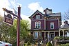 | |
| Backman Homestead | 5219 Highway 3 Chester Basin NS | 44°34′09″N 64°18′03″W / 44.5692°N 64.3008°W / 44.5692; -64.3008 (Backman Homestead) | Chester Basin municipality (15302) | Upload Photo | |
| Bailly House | 134 Pelham Street Lunenburg NS | 44°22′36″N 64°18′32″W / 44.3767°N 64.3088°W / 44.3767; -64.3088 (Bailly House) | Lunenburg municipality (1533) | 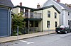 More images | |
| Bayview Cemetery | Edgewater Street, corner of Clearland Mahone Bay NS | 44°27′12″N 64°22′52″W / 44.4534°N 64.3812°W / 44.4534; -64.3812 (Bayview Cemetery) | Mahone Bay municipality (12008) | 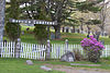 | |
| Captain William Boehner House | 36 Dufferin Street Lunenburg NS | 44°22′45″N 64°19′05″W / 44.3792°N 64.318°W / 44.3792; -64.318 (Captain William Boehner House) | Lunenburg municipality (1799) |  | |
| Boscawen Inn | 150 Cumberland Street Lunenburg NS | 44°22′20″N 64°18′32″W / 44.3722°N 64.3089°W / 44.3722; -64.3089 (Boscawen Inn) | Lunenburg municipality (12624) | Upload Photo | |
| Central United Church | 136 Cumberland Street Lunenburg NS | 44°22′39″N 64°18′32″W / 44.3775°N 64.309°W / 44.3775; -64.309 (Central United Church) | Lunenburg municipality (2066) |  More images | |
| Chester Train Station | 20 Smith Road Chester NS | 44°32′50″N 64°14′43″W / 44.5471°N 64.2452°W / 44.5471; -64.2452 (Chester Train Station) | Chester municipality (7327) | Upload Photo | |
| Chester United Baptist Church | 84 King Street Chester NS | 44°32′25″N 64°14′29″W / 44.5403°N 64.2413°W / 44.5403; -64.2413 (Chester United Baptist Church) | Chester municipality (9188) | Upload Photo | |
| Christ Anglican Church | 4 Forties Road New Ross NS | 44°44′13″N 64°27′25″W / 44.7370°N 64.4570°W / 44.7370; -64.4570 (Christ Anglican Church) | New Ross municipality (10576) | Upload Photo | |
| Christ Anglican Church Rectory | 10 Forties Road New Ross NS | 44°44′12″N 64°27′34″W / 44.7366°N 64.4595°W / 44.7366; -64.4595 (Christ Anglican Church Rectory) | New Ross municipality (10498) | Upload Photo | |
| Corkum-Bezanson Home | 209 Middle River Road Chester Basin NS | 44°34′27″N 64°16′53″W / 44.5741°N 64.2815°W / 44.5741; -64.2815 (Corkum-Bezanson Home) | Chester Basin municipality (9189) | Upload Photo | |
| 49 Cornwallis Street | 49 Cornwallis Street Lunenburg NS | 44°22′43″N 64°18′44″W / 44.3786°N 64.3122°W / 44.3786; -64.3122 (49 Cornwallis Street) | Lunenburg municipality (1609) |  | |
| Countway Home | 12 Lower Grant Road Chester Basin NS | 44°34′03″N 64°17′28″W / 44.5674°N 64.291°W / 44.5674; -64.291 (Countway Home) | Chester Basin municipality (15387) | Upload Photo | |
| Countway Mosher Home | 4956 Highway 3 Middle River NS | 44°33′55″N 64°17′07″W / 44.5652°N 64.2853°W / 44.5652; -64.2853 (Countway Mosher Home) | Middle River municipality (9086) | Upload Photo | |
| 56 Dufferin Street | 56 Dufferin Street Lunenburg NS | 44°22′47″N 64°19′07″W / 44.3797°N 64.3186°W / 44.3797; -64.3186 (56 Dufferin Street) | Lunenburg municipality (2005) |  | |
| 60 Dufferin Street | 60 Dufferin Street Lunenburg NS | 44°22′47″N 64°19′07″W / 44.3798°N 64.3187°W / 44.3798; -64.3187 (60 Dufferin Street) | Lunenburg municipality (1809) |  | |
| East Ironbound Combined Lighthouse and Dwelling | East Ironbound Island Chester area NS | 44°26′22″N 64°05′00″W / 44.4395°N 64.0832°W / 44.4395; -64.0832 (East Ironbound Combined Lighthouse and Dwelling) | Federal (13073) | Upload Photo | |
| 77 Edgewater Street | 77 Edgewater Street Mahone Bay NS | 44°27′03″N 64°22′48″W / 44.4508°N 64.3801°W / 44.4508; -64.3801 (77 Edgewater Street) | Mahone Bay municipality (11801) |  | |
| 97 Edgewater Street | 97 Edgewater Street Mahone Bay NS | 44°27′05″N 64°22′50″W / 44.4514°N 64.3806°W / 44.4514; -64.3806 (97 Edgewater Street) | Mahone Bay municipality (12581) |  More images | |
| 121 Edgewater Street | 121 Edgewater Street Mahone Bay NS | 44°27′09″N 64°22′52″W / 44.4524°N 64.381°W / 44.4524; -64.381 (121 Edgewater Street) | Mahone Bay municipality (11852) |  | |
| Calvin Eisnor Home | 92 Clayton Eisnor Road Chester Basin NS | 44°33′56″N 64°18′01″W / 44.5656°N 64.3002°W / 44.5656; -64.3002 (Calvin Eisnor Home) | Chester Basin municipality (8955) | Upload Photo | |
| John Henry Ernst House | 222 Langille Settlement Road Blockhouse NS | 44°26′56″N 64°25′56″W / 44.4488°N 64.4321°W / 44.4488; -64.4321 (John Henry Ernst House) | Nova Scotia (3466) | 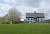 | |
| Eisenhauer House | 430 Borgels Point Road Chester Basin NS | 44°32′59″N 64°18′15″W / 44.5497°N 64.3042°W / 44.5497; -64.3042 (Eisenhauer House) | Nova Scotia (6656) | Upload Photo | |
| James D. Eisenhauer House | 18 Falkland Street Lunenburg NS | 44°22′42″N 64°19′04″W / 44.3782°N 64.3178°W / 44.3782; -64.3178 (James D. Eisenhauer House) | Lunenburg municipality (2767) | 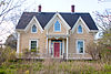 | |
| The Fairview Inn | 25 Queen Street Bridgewater NS | 44°22′34″N 64°31′11″W / 44.376°N 64.5196°W / 44.376; -64.5196 (The Fairview Inn) | Bridgewater municipality (11972) | Upload Photo | |
| Fort Sainte Marie de Grace National Historic Site of Canada | LaHave NS | 44°17′18″N 64°21′05″W / 44.2883°N 64.3514°W / 44.2883; -64.3514 (Fort Sainte Marie de Grace National Historic Site of Canada) | Federal (13572) | 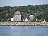 | |
| Geldert House | 205 York Street Lunenburg NS | 44°22′44″N 64°18′20″W / 44.3789°N 64.3056°W / 44.3789; -64.3056 (Geldert House) | Lunenburg municipality (1635) | Upload Photo | |
| William Godley House | 205 Cumberland Street Lunenburg NS | 44°22′39″N 64°18′21″W / 44.3776°N 64.3059°W / 44.3776; -64.3059 (William Godley House) | Lunenburg municipality (2060) |  More images | |
| Gorman House | 42 Pleasant Street Chester NS | 44°32′18″N 64°14′32″W / 44.5382°N 64.2421°W / 44.5382; -64.2421 (Gorman House) | Chester municipality (9190) | Upload Photo | |
| Rafuse Hennigar Home | 743 Chester Grant Road Chester Basin NS | 44°36′50″N 64°19′08″W / 44.6138°N 64.3189°W / 44.6138; -64.3189 (Rafuse Hennigar Home) | Chester Basin municipality (11495) | Upload Photo | |
| Lewis A. Hirtle Photography Shop | 183 Lincoln Street Lunenburg NS | 44°22′39″N 64°18′43″W / 44.3775°N 64.3119°W / 44.3775; -64.3119 (Lewis A. Hirtle Photography Shop) | Lunenburg municipality (1670) | Upload Photo | |
| Robert Herman House | 201 York Street Lunenburg NS | 44°22′44″N 64°18′21″W / 44.3789°N 64.3058°W / 44.3789; -64.3058 (Robert Herman House) | Lunenburg municipality (2694) | Upload Photo | |
| Samuel Herman House | 56 Broad Street Lunenburg NS | 44°22′45″N 64°19′12″W / 44.3792°N 64.32°W / 44.3792; -64.32 (Samuel Herman House) | Lunenburg municipality (1653) |  | |
| James Holland House | 230 Pelham Street Lunenburg NS | 44°22′34″N 64°18′15″W / 44.376°N 64.3043°W / 44.376; -64.3043 (James Holland House) | Lunenburg municipality (2693) | Upload Photo | |
| Holy Trinity Anglican Church | 68 Alexandra Avenue Bridgewater NS | 44°22′21″N 64°30′57″W / 44.3724°N 64.5157°W / 44.3724; -64.5157 (Holy Trinity Anglican Church) | Bridgewater municipality (11932) | Upload Photo | |
| James Hunt House | 331 Lincoln Street Lunenburg NS | 44°22′38″N 64°18′27″W / 44.3773°N 64.3074°W / 44.3773; -64.3074 (James Hunt House) | Lunenburg municipality (2687) | Upload Photo | |
| Jost House | 77 Fox Street Lunenburg NS | 44°22′44″N 64°18′41″W / 44.379°N 64.3115°W / 44.379; -64.3115 (Jost House) | Lunenburg municipality (1640) | 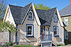 | |
| Kaulbach House | 75 Pelham Street Lunenburg NS | 44°22′37″N 64°18′41″W / 44.3769°N 64.3114°W / 44.3769; -64.3114 (Kaulbach House) | Lunenburg municipality (1414) |  | |
| Alexander Kedy House | 237-249 Edgewater Street Mahone Bay NS | 44°27′21″N 64°22′44″W / 44.4558°N 64.3789°W / 44.4558; -64.3789 (Alexander Kedy House) | Nova Scotia (16205) |  | |
| Knaut-Rhuland House National Historic Site of Canada | 125 Pelham Street Lunenburg NS | 44°22′36″N 64°18′33″W / 44.3768°N 64.3091°W / 44.3768; -64.3091 (Knaut-Rhuland House National Historic Site of Canada) | Federal (8077), Nova Scotia (6488), Lunenburg municipality (1786) | 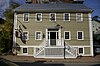 More images | |
| LaHave Islands Marine Museum | 100 LaHave Islands Road LaHave Island NS | 44°13′58″N 64°22′13″W / 44.2327°N 64.3704°W / 44.2327; -64.3704 (LaHave Islands Marine Museum) | LaHave Island municipality (5748) | Upload Photo | |
| Lavers House | 192 Central Street Chester NS | 44°32′39″N 64°14′33″W / 44.5442°N 64.2424°W / 44.5442; -64.2424 (Lavers House) | Chester municipality (11145) | Upload Photo | |
| Larder Home | 4541 Highway 12 New Ross NS | 44°43′26″N 64°27′22″W / 44.7239°N 64.456°W / 44.7239; -64.456 (Larder Home) | New Ross municipality (15303) | Upload Photo | |
| Lennox House | 78 Fox Street Lunenburg NS | 44°22′44″N 64°18′41″W / 44.3788°N 64.3115°W / 44.3788; -64.3115 (Lennox House) | Lunenburg municipality (1654) |  | |
| Lennox Tavern | 69 Fox Street Lunenburg NS | 44°22′44″N 64°18′42″W / 44.379°N 64.3118°W / 44.379; -64.3118 (Lennox Tavern) | Nova Scotia (3529), Lunenburg municipality (1299) | Upload Photo | |
| 112-118 Lincoln Street | 112-118 Lincoln Street Lunenburg NS | 44°22′40″N 64°18′50″W / 44.3778°N 64.3139°W / 44.3778; -64.3139 (112-118 Lincoln Street) | Lunenburg municipality (1667) |  More images | |
| Lordly House | 133 Central Street Chester NS | 44°19′21″N 64°08′35″W / 44.3224°N 64.1431°W / 44.3224; -64.1431 (Lordly House) | Chester municipality (7237) | Upload Photo | |
| Lunenburg Academy National Historic Site of Canada | 101 Kaulback Street Lunenburg NS | 44°22′09″N 64°17′48″W / 44.3693°N 64.2966°W / 44.3693; -64.2966 (Lunenburg Academy National Historic Site of Canada) | Federal (13179), Nova Scotia (6483), Lunenburg municipality (1517) |  More images | |
| Lunenburg Inn | 26 Dufferin Street Lunenburg NS | 44°22′44″N 64°19′04″W / 44.3789°N 64.3178°W / 44.3789; -64.3178 (Lunenburg Inn) | Lunenburg municipality (2033) |  | |
| Lunenburg Old Town Heritage Conservation District | Old Town Lunenburg NS | 44°22′41″N 64°18′35″W / 44.378°N 64.3098°W / 44.378; -64.3098 (Lunenburg Old Town Heritage Conservation District) | Lunenburg municipality (2253) |  More images | |
| Lunenburg Town Hall | 119 Cumberland Street Lunenburg NS | 44°22′41″N 64°18′35″W / 44.378°N 64.3098°W / 44.378; -64.3098 (Lunenburg Town Hall) | Lunenburg municipality (1611) |  More images | |
| MacIsaac House | 19 Hospital Road Garden Lots NS | 44°22′25″N 64°17′56″W / 44.3735°N 64.2988°W / 44.3735; -64.2988 (MacIsaac House) | Garden Lots municipality (5746) | Upload Photo | |
| 328 Main Street | 328 Main Street Mahone Bay NS | 44°27′03″N 64°23′25″W / 44.4509°N 64.3902°W / 44.4509; -64.3902 (328 Main Street) | Mahone Bay municipality (12035) | Upload Photo | |
| 578 Main Street | 578 Main Street Mahone Bay NS | 44°26′56″N 64°22′44″W / 44.4488°N 64.379°W / 44.4488; -64.379 (578 Main Street) | Mahone Bay municipality (11861) | Upload Photo | |
| 674 Main Street | 674 Main Street Mahone Bay NS | 44°26′50″N 64°22′31″W / 44.4471°N 64.3752°W / 44.4471; -64.3752 (674 Main Street) | Mahone Bay municipality (12066) |  | |
| 680 Main Street | 680 Main Street Mahone Bay NS | 44°26′49″N 64°22′30″W / 44.447°N 64.375°W / 44.447; -64.375 (680 Main Street) | Mahone Bay municipality (12096) |  | |
| Manuels Inn | 17 Croft Road Chester Basin NS | 44°33′58″N 64°18′41″W / 44.5662°N 64.3115°W / 44.5662; -64.3115 (Manuels Inn) | Chester Basin municipality (8500) | Upload Photo | |
| Mayner House | 185 Townsend Street Lunenburg NS | 44°22′41″N 64°18′24″W / 44.3781°N 64.3066°W / 44.3781; -64.3066 (Mayner House) | Lunenburg municipality (1575) |  More images | |
| McKittrick House | 48 Dufferin Street Lunenburg NS | 44°22′46″N 64°19′08″W / 44.3795°N 64.3188°W / 44.3795; -64.3188 (McKittrick House) | Lunenburg municipality (1789) |  | |
| McLachlan House | 306 Lincoln Street Lunenburg NS | 44°22′37″N 64°18′31″W / 44.3769°N 64.3086°W / 44.3769; -64.3086 (McLachlan House) | Lunenburg municipality (12625) |  | |
| Lincoln Meister House | 4865 Highway 12 New Ross NS | 44°44′23″N 64°27′28″W / 44.7398°N 64.4578°W / 44.7398; -64.4578 (Lincoln Meister House) | New Ross municipality (10704) | Upload Photo | |
| Mizpah Cottage | 75 Dufferin Street Lunenburg NS | 44°22′48″N 64°19′12″W / 44.3799°N 64.3199°W / 44.3799; -64.3199 (Mizpah Cottage) | Lunenburg municipality (10837) | 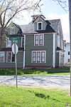 | |
| 207 Montague Street | 207 Montague Street Lunenburg NS | 44°22′35″N 64°18′24″W / 44.3763°N 64.3066°W / 44.3763; -64.3066 (207 Montague Street) | Lunenburg municipality (1655) | Upload Photo | |
| Morash Emporium | 55 Montague Street Lunenburg NS | 44°22′37″N 64°18′44″W / 44.3769°N 64.3122°W / 44.3769; -64.3122 (Morash Emporium) | Lunenburg municipality (2022) | Upload Photo | |
| Allan R. Morash House | 43 York Street Lunenburg NS | 44°22′47″N 64°18′46″W / 44.3797°N 64.3128°W / 44.3797; -64.3128 (Allan R. Morash House) | Lunenburg municipality (2068) |  | |
| Naas House | 8 Tannery Road Lunenburg NS | 44°22′33″N 64°19′12″W / 44.3758°N 64.32°W / 44.3758; -64.32 (Naas House) | Lunenburg municipality (2057) | Upload Photo | |
| David Nauss House | 255 Haddon Hill Road Chester NS | 44°33′22″N 64°15′12″W / 44.5561°N 64.2533°W / 44.5561; -64.2533 (David Nauss House) | Chester municipality (8926) | Upload Photo | |
| Henry Neil Property | 242 Lincoln Street Lunenburg NS | 44°22′38″N 64°18′37″W / 44.3772°N 64.3104°W / 44.3772; -64.3104 (Henry Neil Property) | Lunenburg municipality (1798) |  More images | |
| Northwest United Baptist Church | 1609 Big Lots Road Fauxburg NS | 44°24′49″N 64°22′03″W / 44.4137°N 64.3676°W / 44.4137; -64.3676 (Northwest United Baptist Church) | Nova Scotia (6567) |  | |
| Old Methodist Church | 14 Main Street Chester NS | 44°32′42″N 64°14′21″W / 44.5450°N 64.2391°W / 44.5450; -64.2391 (Old Methodist Church) | Chester municipality (7236) | Upload Photo | |
| Old New Town School | 17 Tannery Road Lunenburg NS | 44°22′33″N 64°19′08″W / 44.3759°N 64.319°W / 44.3759; -64.319 (Old New Town School) | Lunenburg municipality (2688) |  | |
| Old Town Lunenburg Historic District National Historic Site of Canada | Bluenose Drive, Lunenburg Harbour Lunenburg NS | 44°22′40″N 64°18′35″W / 44.3779°N 64.3096°W / 44.3779; -64.3096 (Old Town Lunenburg Historic District National Historic Site of Canada) | Federal (4256) | | |
| Oxner-Zinck House | 172 Highway 12 Chester Basin NS | 44°34′16″N 64°18′44″W / 44.571°N 64.3122°W / 44.571; -64.3122 (Oxner-Zinck House) | Chester Basin municipality (10632) | Upload Photo | |
| Samuel Prescott House | 55 Central Street Chester NS | 44°32′17″N 64°14′34″W / 44.538°N 64.2428°W / 44.538; -64.2428 (Samuel Prescott House) | Chester municipality (6963) | Upload Photo | |
| Quarter Deck | 6 Queen Street Chester NS | 44°19′16″N 64°08′32″W / 44.3211°N 64.1423°W / 44.3211; -64.1423 (Quarter Deck) | Chester municipality (7020) | Upload Photo | |
| Riverview Community Centre | 1153 King Street Bridgewater NS | 44°23′24″N 64°31′58″W / 44.39°N 64.5329°W / 44.39; -64.5329 (Riverview Community Centre) | Bridgewater municipality (11901) | Upload Photo | |
| Robinson House | 78 Queen Street Chester NS | 44°32′24″N 64°14′24″W / 44.5401°N 64.2401°W / 44.5401; -64.2401 (Robinson House) | Chester municipality (6964) | Upload Photo | |
| Rosebank Cottage | Ross Farm Museum; 4568 Highway 12 New Ross NS | 44°43′36″N 64°27′25″W / 44.7266°N 64.4570°W / 44.7266; -64.4570 (Rosebank Cottage) | New Ross municipality (8748) | Upload Photo | |
| Daniel Rudolf House | 325 Lincoln Street Lunenburg NS | 44°22′38″N 64°18′28″W / 44.3773°N 64.3077°W / 44.3773; -64.3077 (Daniel Rudolf House) | Lunenburg municipality (2136) | 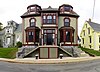 More images | |
| Saint Andrews Presbyterian Church | 3483 Highway 332 Rose Bay NS | 44°17′55″N 64°18′22″W / 44.2986°N 64.3061°W / 44.2986; -64.3061 (Saint Andrews Presbyterian Church) | Rose Bay municipality (5714) |  More images | |
| St. Andrew's Presbyterian Church | 111 Townsend Street Lunenburg NS | 44°22′38″N 64°18′27″W / 44.3773°N 64.3074°W / 44.3773; -64.3074 (St. Andrew's Presbyterian Church) | Lunenburg municipality (1639) | Upload Photo | |
| St. Barnabas Anglican Church | 4936 Highway 329 Blandford NS | 44°29′44″N 64°06′32″W / 44.4956°N 64.1090°W / 44.4956; -64.1090 (St. Barnabas Anglican Church) | Blandford municipality (11196) | Upload Photo | |
| Saint Barnabas' Church | 1396 Blue Rocks Road Blue Rocks NS | 44°21′22″N 64°14′33″W / 44.3562°N 64.2425°W / 44.3562; -64.2425 (Saint Barnabas' Church) | Blue Rocks municipality (5729) | Upload Photo | |
| St. George's Anglican Church | 7338 Highway No 329 East River NS | 44°34′25″N 64°09′14″W / 44.5735°N 64.1538°W / 44.5735; -64.1538 (St. George's Anglican Church) | East River municipality (10929) | Upload Photo | |
| St. James' Anglican Church | 65 Edgewater Street Mahone Bay NS | 44°27′02″N 64°22′48″W / 44.4505°N 64.38°W / 44.4505; -64.38 (St. James' Anglican Church) | Mahone Bay municipality (11975) |  More images | |
| St. John's Anglican Church - National Historic Site of Canada | 2 Cumberland Street Lunenburg NS | 44°22′41″N 64°18′41″W / 44.3781°N 64.3115°W / 44.3781; -64.3115 (St. John's Anglican Church - National Historic Site of Canada) | Federal (12344), Nova Scotia (5449) |  More images | |
| St. John's Anglican Church Rectory | 58 Townsend Street Lunenburg NS | 44°22′42″N 64°18′46″W / 44.3783°N 64.3128°W / 44.3783; -64.3128 (St. John's Anglican Church Rectory) | Lunenburg municipality (2009) | Upload Photo | |
| St. John's Evangelical Lutheran Church | 89 Edgewater Street Mahone Bay NS | 44°27′04″N 64°22′49″W / 44.4512°N 64.3804°W / 44.4512; -64.3804 (St. John's Evangelical Lutheran Church) | Mahone Bay municipality (12058) | 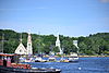 More images | |
| St. John Evangelist Anglican Church | 388 LaHave Islands Road Bell Island, LaHave Island NS | 44°13′32″N 64°21′32″W / 44.2255°N 64.3589°W / 44.2255; -64.3589 (St. John Evangelist Anglican Church) | Bell Island, LaHave Island municipality (5683) | Upload Photo | |
| St. John's Parish Hall | 65 Cumberland Street Lunenburg NS | 44°22′42″N 64°18′44″W / 44.3783°N 64.3123°W / 44.3783; -64.3123 (St. John's Parish Hall) | Lunenburg municipality (2014) | Upload Photo | |
| Saint Mark's Evangelical Lutheran Church | 1231 Back Cornwall Road Middle New Cornwall NS | 44°30′12″N 64°28′47″W / 44.5034°N 64.4798°W / 44.5034; -64.4798 (Saint Mark's Evangelical Lutheran Church) | Middle New Cornwall municipality (5751) | Upload Photo | |
| St. Matthew's Evangelical Lutheran Church | 3472 No. 332 Highway Rose Bay NS | 44°17′54″N 64°18′22″W / 44.2984°N 64.3062°W / 44.2984; -64.3062 (St. Matthew's Evangelical Lutheran Church) | Rose Bay municipality (5684) |  More images | |
| St. Norbert's Roman Catholic Church | 121 York Street Lunenburg NS | 44°22′45″N 64°18′35″W / 44.3792°N 64.3096°W / 44.3792; -64.3096 (St. Norbert's Roman Catholic Church) | Lunenburg municipality (2135) | 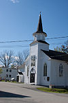 | |
| St. Paul's United Church | 135 Stonehurst Road Blue Rocks NS | 44°21′40″N 64°14′17″W / 44.361°N 64.2381°W / 44.361; -64.2381 (St. Paul's United Church) | Blue Rocks municipality (5752) | Upload Photo | |
| St. Peter's Lutheran Church | 5 Old Trunk Road No. 3 (Commons Road) Chester NS | 44°33′00″N 64°14′00″W / 44.5501°N 64.2332°W / 44.5501; -64.2332 (St. Peter's Lutheran Church) | Chester municipality (9180) | Upload Photo | |
| St. Stephen's Anglican Church | 60 Regent Street Chester NS | 44°32′29″N 64°14′32″W / 44.5415°N 64.2423°W / 44.5415; -64.2423 (St. Stephen's Anglican Church) | Chester municipality (11326) | Upload Photo | |
| 38 School Street | 38 School Street Mahone Bay NS | 44°26′49″N 64°22′50″W / 44.447°N 64.3806°W / 44.447; -64.3806 (38 School Street) | Mahone Bay municipality (11845) |  | |
| Selig House | 74 Cornwallis Street Lunenburg NS | 44°22′46″N 64°18′41″W / 44.3795°N 64.3115°W / 44.3795; -64.3115 (Selig House) | Lunenburg municipality (2684) |  | |
| Simpsons Corner Union Church | 1315 Highway 208 Simpsons Corner NS | 44°32′26″N 64°46′53″W / 44.5405°N 64.7815°W / 44.5405; -64.7815 (Simpsons Corner Union Church) | Simpsons Corner municipality (5731) | Upload Photo | |
| Smith House | 58 Hopson Street Lunenburg NS | 44°22′42″N 64°18′24″W / 44.3783°N 64.3067°W / 44.3783; -64.3067 (Smith House) | Lunenburg municipality (1529) |  More images | |
| Charles Smith House | 321 Lincoln Street Lunenburg NS | 44°22′38″N 64°18′28″W / 44.3773°N 64.3079°W / 44.3773; -64.3079 (Charles Smith House) | Lunenburg municipality (1672) |  More images | |
| Captain William Smith House | 361 Lincoln Street Lunenburg NS | 44°22′38″N 64°18′22″W / 44.3771°N 64.3061°W / 44.3771; -64.3061 (Captain William Smith House) | Lunenburg municipality (2004) |  More images | |
| Solomon House | 69 Townsend Street Lunenburg NS | 44°22′49″N 64°18′49″W / 44.3802°N 64.3137°W / 44.3802; -64.3137 (Solomon House) | Lunenburg municipality (1549) | Upload Photo | |
| Taffrail Cottage | 18 Queen Street Chester NS | 44°19′17″N 64°08′33″W / 44.3215°N 64.1424°W / 44.3215; -64.1424 (Taffrail Cottage) | Chester municipality (6966) | Upload Photo | |
| Terrace Cottage | 19 King Street Chester NS | 44°32′15″N 64°14′31″W / 44.5376°N 64.242°W / 44.5376; -64.242 (Terrace Cottage) | Chester municipality (6965) | Upload Photo | |
| Trinity United Church | 101 Edgewater Street Mahone Bay NS | 44°27′06″N 64°22′50″W / 44.4516°N 64.3806°W / 44.4516; -64.3806 (Trinity United Church) | Mahone Bay municipality (12095) | Upload Photo | |
| Union Church of Indian Point | 181 Indian Point Road Indian Point NS | 44°27′37″N 64°18′44″W / 44.4604°N 64.3123°W / 44.4604; -64.3123 (Union Church of Indian Point) | Indian Point municipality (5732) | Upload Photo | |
| United Baptist Church, Mahone Bay | 56 Maple Street Mahone Bay NS | 44°26′48″N 64°22′46″W / 44.4468°N 64.3795°W / 44.4468; -64.3795 (United Baptist Church, Mahone Bay) | Mahone Bay municipality (12097) |  | |
| Zoé Vallé Library | 63 Regent Street Chester NS | 44°32′29″N 64°14′32″W / 44.5413°N 64.2423°W / 44.5413; -64.2423 (Zoé Vallé Library) | Chester municipality (7005) |  | |
| Walters Blacksmith Shop | 2 Kempt Street Lunenburg NS | 44°22′34″N 64°18′21″W / 44.3761°N 64.3058°W / 44.3761; -64.3058 (Walters Blacksmith Shop) | Lunenburg municipality (2056) | Upload Photo | |
| Captain Angus Walters House | 37 Tannery Road Lunenburg NS | 44°22′30″N 64°19′08″W / 44.375°N 64.3189°W / 44.375; -64.3189 (Captain Angus Walters House) | Lunenburg municipality (2692) | Upload Photo | |
| Wecob | Wake Up Hill Road Marriotts Cove NS | 44°33′26″N 64°16′13″W / 44.5571°N 64.2702°W / 44.5571; -64.2702 (Wecob) | Nova Scotia (7423), Marriotts Cove municipality (15301) | Upload Photo | |
| Wilson House | 315 Lincoln Street Lunenburg NS | 44°22′38″N 64°18′30″W / 44.3772°N 64.3083°W / 44.3772; -64.3083 (Wilson House) | Lunenburg municipality (1936) |  More images | |
| Wolff House | 28 King Street Lunenburg NS | 44°22′39″N 64°18′34″W / 44.3774°N 64.3094°W / 44.3774; -64.3094 (Wolff House) | Lunenburg municipality (2032) |  More images | |
| Young House | 95 Montague Street Lunenburg NS | 44°22′36″N 64°18′38″W / 44.3767°N 64.3106°W / 44.3767; -64.3106 (Young House) | Lunenburg municipality (2690) | Upload Photo | |
| John B. Young House | 21 Falkland Street Lunenburg NS | 44°22′40″N 64°19′02″W / 44.3778°N 64.3173°W / 44.3778; -64.3173 (John B. Young House) | Lunenburg municipality (2051) |  | |
| Zion Evangelical Lutheran Church | 65 Fox Street Lunenburg NS | 44°22′45″N 64°18′44″W / 44.3792°N 64.3121°W / 44.3792; -64.3121 (Zion Evangelical Lutheran Church) | Nova Scotia (6281), Lunenburg municipality (1666) |  | |
| Zwicker House | 13-15 King Street Lunenburg NS | 44°22′38″N 64°18′36″W / 44.3771°N 64.31°W / 44.3771; -64.31 (Zwicker House) | Lunenburg municipality (2171) |  More images |
See also
Wikimedia Commons has media related to Cultural heritage monuments in Nova Scotia.
- List of historic places in Nova Scotia
- List of National Historic Sites of Canada in Nova Scotia
- Heritage Property Act (Nova Scotia)
- v
- t
- e
- CRHP
- Annapolis County
- Antigonish County
- Cape Breton RM
- Colchester County
- Cumberland County
- Digby County
- Guysborough County
- Halifax RM
- Hants County
- Inverness County
- Kings County
- Lunenburg County
- Pictou County
- Region of Queens Municipality
- Richmond County
- Shelburne County
- Victoria County
- Yarmouth County
- Acacia Grove / Prescott House
- Admiralty House
- Africville
- Akins House
- Alexander Graham Bell
- Annapolis County Court House
- Annapolis Royal Historic District
- Antigonish County Court House
- Argyle Township Court House and Jail
- Beaubassin
- Bedford Petroglyphs
- Beinn Bhreagh Hall
- Black-Binney House
- Bloody Creek
- Canso Islands
- Cast Iron Façade / Coomb's Old English Shoe Store
- Chapel Island
- Chapman House
- Charles Fort
- Covenaters' Church
- D'Anville's Encampment
- Debert Palaeo-Indian Site
- Fernwood
- Fort Anne
- Fort Edward
- Fort Lawrence
- Fort McNab
- Fort St. Louis
- Fort Sainte Marie de Grace
- Fortress of Louisbourg
- Georges Island
- Government House
- Grand-Pré & Grand-Pré Rural Historic District
- Granville Block
- Grassy Island Fort
- Halifax Citadel
- Halifax City Hall
- Halifax Court House
- Halifax Armoury
- Halifax Dockyard
- Halifax Public Gardens
- Halifax Waterfront Buildings
- Halifax WWII Coastal Defences
- Henry House
- HMCS Sackville
- Hydrostone District
- Jonathan McCully House
- Kejimkujik
- King's College
- Knaut–Rhuland House
- Ladies' Seminary
- Little Dutch (Deutsch) Church
- Liverpool Town Hall
- Lunenburg Academy
- Marconi & Marconi Wireless Station
- Melanson Settlement
- Melville Island & Deadman's Island
- Nova Scotia Coal Fields
- Old Barrington Meeting House
- Old Burying Ground
- Old Town Lunenburg Historic District
- Pictou Academy
- Pictou Railway Station (Intercolonial)
- Pier 21
- Port-Royal
- Prince of Wales Tower
- Province House
- Royal Battery
- SS Acadia
- Sainte-Anne / Port Dauphin
- Sinclair Inn / Farmer's Hotel
- Sir Frederick Borden Residence
- Springhill Coal Mining
- St. George's Anglican Church / Round Church
- St. John's Anglican Church
- St. Mary's Basilica
- St. Paul's Anglican Church
- St. Peter's
- St. Peters Canal
- Sydney WWII Coastal Defences
- Thinkers' Lodge
- Trinity Anglican Church
- Truro Old Normal College
- Truro Post Office
- Wolfe's Landing
- York Redoubt
areas & others
 Category
 Commons
 Canada portal


