This is a list of lighthouses in Bermuda.[1][2]
Lighthouses
[edit]| Name | Image | Year built |
Location & coordinates |
Class of Light [2] |
Focal height [2] |
ARLHS number |
Admiralty number [2] |
Range nml [2] |
|---|---|---|---|---|---|---|---|---|
| Chub Heads Lighthouse | n/a | offshore Sandys Parish 32°17′11″N 64°58′47″W / 32.286274°N 64.979749°W |
V Q (9) W 15s. | 18 metres (59 ft) | BER-017 | J4546 | 12 | |
| Eastern Blue Cut Lighthouse | Image | n/a | offshore Ireland Island 32°23′50.0″N 64°52′36.8″W / 32.397222°N 64.876889°W |
Mo (U) W 10s. | 18 metres (59 ft) | BER-011 | J4547 | 12 |
| Gibbs Hill Lighthouse |  |
1844 | Southampton Parish 32°15′10″N 64°50′05″W / 32.25282°N 64.83475°W |
Fl W 10s. | 108 metres (354 ft) | BER-010 | J4550 | 26 |
| Hinson's Island Lighthouse | n/a | Hinson's Island 32°17′04″N 64°48′22″W / 32.284444°N 64.806119°W |
Fl R 2.5s. | 4 metres (13 ft) | 11752 | J4506 | 5 | |
| Hogfish Cut Lighthouse | n/a | offshore Southampton Parish 32°15′34″N 64°53′01″W / 32.259333°N 64.883501°W |
Fl R 4s. | 4 metres (13 ft) | 11736 | J4544 | 5 | |
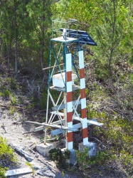
| Horseshoe Island Lighthouse | Image | n/a | St. George's 32°22′40″N 64°39′54″W / 32.377649°N 64.664995°W |
F G | n/a | n/a | J4476.5 | 8 |
| Kitchen Shoal Lighthouse | Image | n/a | offshore 4 miles north-east of St. George's 32°26′04.2″N 64°37′40.2″W / 32.434500°N 64.627833°W |
Fl (3) W 15s. | 14 metres (46 ft) | BER-014 | J4471.5 | 12 |
| North Rock Lighthouse | Image | 1912 est. | offshore 8 miles north of St. George's 32°28′31″N 64°46′09″W / 32.475338°N 64.769039°W |
Fl (4) W 20s. | 21 metres (69 ft) | BER-015 | J4471 | 12 |
| North East Breaker Lighthouse | n/a | 6 miles north of St. George's 32°28′43″N 64°40′56″W / 32.478500°N 64.682344°W |
Fl W 2.5s. | 14 metres (46 ft) | BER-018 | J4471.3 | 12 | |
| Pearl Island Lighthouse | n/a | Great Sound 32°17′30″N 64°50′14″W / 32.291791°N 64.837280°W |
Fl Y 4s. | 6 metres (20 ft) | J4514 | 5 | ||
| St. David's Lighthouse |  |
1879 | St. David's Island 32°21′51″N 64°39′06″W / 32.36403°N 64.65166°W |
Fl (2) W 20s. F R G |
65 metres (213 ft) | BER-009 | J4472 | 15 |
| Town Cut Channel Outer Lighthouse |  |
n/a | St. George's 32°22′44″N 64°39′49″W / 32.378803°N 64.663519°W |
F R | 14 metres (46 ft) | J4477 | 8 | |
| Two Rocks Passage Lighthouse | n/a | Great Sound 32°17′33″N 64°48′41″W / 32.292465°N 64.811347°W |
V Q G | 6 metres (20 ft) | J4498 | 5 |
See also
[edit]References
[edit]- ^ Rowlett, Russ. "Lighthouses of Bermuda". The Lighthouse Directory. University of North Carolina at Chapel Hill. Retrieved 25 June 2016.
- ^ a b c d e List of Lights, Pub. 110: Greenland, The East Coasts of North and South America (Excluding Continental U.S.A. Except the East Coast of Florida) and the West Indies (PDF). List of Lights. United States National Geospatial-Intelligence Agency. 2016.
External links
[edit]Wikimedia Commons has media related to Lighthouses in Bermuda.
- Rowlett, Russ. "The Lighthouse Directory". University of North Carolina at Chapel Hill.
| Types |
| _-_cropped.jpg) | ||||
|---|---|---|---|---|---|---|
| Fixtures | ||||||
| Maintenance | ||||||
| Locations | ||||||
| Categories | ||||||
| Global organizations | ||||||