Lom, Norway
Municipality in Innlandet, Norway
Municipality in Innlandet, Norway
Lom Municipality Lom kommune | |
|---|---|
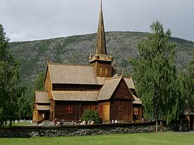
 View of the local Lom Stave Church | |
 Flag  Coat of arms | |
 Innlandet within Norway | |
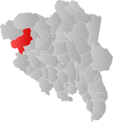 Lom within Innlandet | |
| Coordinates: 61°48′39″N 8°38′21″E / 61.81083°N 8.63917°E / 61.81083; 8.63917 | |
| Country | Norway |
| County | Innlandet |
| District | Gudbrandsdalen |
| Established | 1 Jan 1838 |
| • Created as | Formannskapsdistrikt |
| Administrative centre | Fossbergom |
| Government | |
| • Mayor (2023) | Kristian Frisvold (LL) |
| Area | |
| • Total | 1,968.54 km2 (760.06 sq mi) |
| • Land | 1,887.26 km2 (728.68 sq mi) |
| • Water | 81.29 km2 (31.39 sq mi) 4.1% |
| • Rank | #38 in Norway |
| Population (2023) | |
| • Total | 2,212 |
| • Rank | #266 in Norway |
| • Density | 1.2/km2 (3/sq mi) |
| • Change (10 years) |  −6.4% −6.4% |
| Demonym | Lomvær[1] |
| Official language | |
| • Norwegian form | Nynorsk |
| Time zone | UTC+01:00 (CET) |
| • Summer (DST) | UTC+02:00 (CEST) |
| ISO 3166 code | NO-3434[3] |
| Website | Official website |
Data from Statistics Norway | |
Lom is a municipality in Innlandet county, Norway. It is located in the traditional district of Gudbrandsdal. The administrative centre of the municipality is the village of Fossbergom. Another village area in Lom is Elvesæter.
The 1,969-square-kilometre (760 sq mi) municipality is the 38th largest by area out of the 356 municipalities in Norway. Lom is the 266th most populous municipality in Norway with a population of 2,212. The municipality's population density is 1.2 inhabitants per square kilometre (3.1/sq mi) and its population has decreased by 6.4% over the previous 10-year period.[4][5]
Lom is famous for its extensive history, for Lom Stave Church, one of the few remaining stave churches in Norway. Also for being located in the midst of the highest mountains in Northern Europe.
General information
The prestegjeld (parish) of Lom was established as a municipality on 1 January 1838 (see formannskapsdistrikt law). On 1 January 1866, the western district of Lom (population: 2,691) was separated and established as the new municipality of Skiaker. Afterwards, the remaining part of Lom had 3,299 residents. The boundaries of Lom have not changed since that time.[6]
Name
The municipality (originally the parish) is named after the old Lom farm since the first Lom Stave Church was built there. The Old Norse form of the name was Lóar (nominative case) and Lóm (dative case). The name is derived from the plural form of ló which means "clearing" or "meadow".[7]
Coat of arms
The coat of arms was granted on 6 February 1987. The official blazon is "Azure, three shovels argent palewise in fess" (Norwegian: På blå grunn tre sølv skjeltrekor). This means the arms have a blue field (background) and the charge is three vertical spades lined up horizontally. The charge has a tincture of argent which means it is commonly colored white, but if it is made out of metal, then silver is used. These spades (Norwegian: skjeltrekor) were historically used to scoop water from the irrigation channels typical for the area. The area is one of the driest in Norway, but the soil is good for agriculture. It thus needs irrigation. In the 17th century, a system was developed in which melting water from the mountains was transported to the area using wooden channels or aqueducts. The water was further divided using irrigation channels. The arms were designed by Einar H. Skjervold. The municipal flag has the same design as the coat of arms.[8][9][10]
Churches
The Church of Norway has three parishes (sokn) within the municipality of Lom. It is part of the Nord-Gudbrandsdal prosti (deanery) in the Diocese of Hamar.
| Parish (sokn) | Church name | Location of the church | Year built |
|---|---|---|---|
| Bøverdalen | Bøverdal Church | Galdesanden (Bøverdalen) | 1864 |
| Garmo | Garmo Church | Garmo | 1879 |
| Lom | Lom Stave Church | Fossbergom | c. 1160 |
History
| Ancestry | Number |
|---|---|
 Somalia Somalia | 31 |
 Germany Germany | 18 |
 Eritrea Eritrea | 17 |
An ancient trade route passed up from Sunnmøre through Lom and Skjåk and down the Gudbrandsdalen valley into Eastern Norway. The trade consisted of fish and salt heading inland, and grain heading to the coast.
The Saga of Olaf Haraldson relates that St. Olaf commented as he first looked down on Lom, "What a pity to have to lay waste to such a beautiful valley." In the face of such a clear motivation, the residents of the valley converted (it has since been a recurring discussion whether he looked to Lom or the neighbouring municipality Skjåk, at the time a part of Lom.) St. Olafs-stuggu, a building where St. Olaf is reported to have spent a night in 1021, can still be found here. The building is part of the Presthaugen District Museum.
Lom Stave Church, which is located in Fossbergom, is believed to have been built in 1158, making 2008 the 850th anniversary. It was enlarged in 1634, with further addition of two naves in 1667. It is believed that the church was originally surrounded by a circumambulatory passage, like many other Norwegian stave churches, but that this passage was removed when the two side wings were added. A few Runic inscriptions can be still be seen in the church. The church also contains numerous paintings from the 17th and 18th centuries with religious motifs. Many of the paintings were made by local artist Eggert Munch, a distant relation of the famous Edvard Munch. The church also contains numerous examples of local woodcarving, as seen in the elaborate acanthus scrolls adorning the pulpit. Carved dragon figures on the roof are old symbols of protection against evil. It is still in use as the local church.
The Garmo Stave Church, which was built around 1150, has been relocated from Lom municipality and is now at Maihaugen in Lillehammer. It was replaced with a new Garmo Church.
During the 1940 Norwegian Campaign German prisoners of war were kept by the Norwegian Army at Lom prisoner of war camp. Lom was bombed twice by the German Luftwaffe in April 1940.[12]
Government
Lom Municipality is responsible for primary education (through 10th grade), outpatient health services, senior citizen services, welfare and other social services, zoning, economic development, and municipal roads and utilities. The municipality is governed by a municipal council of directly elected representatives. The mayor is indirectly elected by a vote of the municipal council.[13] The municipality is under the jurisdiction of the Vestre Innlandet District Court and the Eidsivating Court of Appeal.
Municipal council
The municipal council (Kommunestyre) of Lom is made up of 17 representatives that are elected to four year terms. The tables below show the current and historical composition of the council by political party.
| Party name (in Nynorsk) | Number of representatives | |
|---|---|---|
| Labour Party (Arbeidarpartiet) | 3 | |
| Centre Party (Senterpartiet) | 4 | |
| Lom List (Lomslista) | 4 | |
| Local List (Bygdalista) | 5 | |
| Cross-party List (Tverrpolitisk liste) | 1 | |
| Total number of members: | 17 | |
| Party name (in Nynorsk) | Number of representatives | |
|---|---|---|
| Labour Party (Arbeidarpartiet) | 4 | |
| Centre Party (Senterpartiet) | 7 | |
| Lom List (Lomslista) | 4 | |
| Local List (Bygdalista) | 2 | |
| Total number of members: | 17 | |
| Party name (in Nynorsk) | Number of representatives | |
|---|---|---|
| Labour Party (Arbeidarpartiet) | 4 | |
| Centre Party (Senterpartiet) | 8 | |
| Lom List (Lomslista) | 2 | |
| Local List (Bygdalista) | 3 | |
| Total number of members: | 17 | |
| Party name (in Nynorsk) | Number of representatives | |
|---|---|---|
| Labour Party (Arbeidarpartiet) | 5 | |
| Centre Party (Senterpartiet) | 6 | |
| Lom List (Lomslista) | 3 | |
| Local List in Lom (Bygdalista i Lom) | 3 | |
| Total number of members: | 17 | |
| Party name (in Nynorsk) | Number of representatives | |
|---|---|---|
| Labour Party (Arbeidarpartiet) | 3 | |
| Centre Party (Senterpartiet) | 11 | |
| Local list in Lom (Bygdelista i Lom) | 3 | |
| Total number of members: | 17 | |
| Party name (in Nynorsk) | Number of representatives | |
|---|---|---|
| Labour Party (Arbeidarpartiet) | 5 | |
| Centre Party (Senterpartiet) | 9 | |
| Local list in Lom (Bygdelista i Lom) | 3 | |
| Total number of members: | 17 | |
| Party name (in Nynorsk) | Number of representatives | |
|---|---|---|
| Labour Party (Arbeidarpartiet) | 8 | |
| Centre Party (Senterpartiet) | 6 | |
| Local list for cross-party cooperation (Bygdalista for tverrpolitisk samarbeid) | 7 | |
| Total number of members: | 21 | |
| Party name (in Nynorsk) | Number of representatives | |
|---|---|---|
| Labour Party (Arbeidarpartiet) | 11 | |
| Centre Party (Senterpartiet) | 8 | |
| Local list for cross-party cooperation (Bygdalista for tverrpolitisk samarbeid) | 2 | |
| Total number of members: | 21 | |
| Party name (in Nynorsk) | Number of representatives | |
|---|---|---|
| Labour Party (Arbeidarpartiet) | 10 | |
| Conservative Party (Høgre) | 1 | |
| Centre Party (Senterpartiet) | 7 | |
| Local list for cross-party cooperation (Bygdalista for tverrpolitisk samarbeid) | 3 | |
| Total number of members: | 21 | |
| Party name (in Nynorsk) | Number of representatives | |
|---|---|---|
| Labour Party (Arbeidarpartiet) | 11 | |
| Conservative Party (Høgre) | 2 | |
| Centre Party (Senterpartiet) | 4 | |
| Local list for cross-party cooperation (Bygdalista for tverrpolitisk samarbeid) | 4 | |
| Total number of members: | 21 | |
| Party name (in Nynorsk) | Number of representatives | |
|---|---|---|
| Labour Party (Arbeidarpartiet) | 11 | |
| Conservative Party (Høgre) | 2 | |
| Centre Party (Senterpartiet) | 6 | |
| Local list for cross-party cooperation (Bygdalista for tverrpolitisk samarbeid) | 2 | |
| Total number of members: | 21 | |
| Party name (in Nynorsk) | Number of representatives | |
|---|---|---|
| Labour Party (Arbeidarpartiet) | 9 | |
| Conservative Party (Høgre) | 2 | |
| Centre Party (Senterpartiet) | 7 | |
| Local list for cross-party cooperation (Bygdalista for tverrpolitisk samarbeid) | 3 | |
| Total number of members: | 21 | |
| Party name (in Nynorsk) | Number of representatives | |
|---|---|---|
| Labour Party (Arbeidarpartiet) | 10 | |
| Centre Party (Senterpartiet) | 7 | |
| Local list for cross-party cooperation (Bygdalista for tverrpolitisk samarbeid) | 4 | |
| Total number of members: | 21 | |
| Party name (in Nynorsk) | Number of representatives | |
|---|---|---|
| Labour Party (Arbeidarpartiet) | 11 | |
| Joint List(s) of Non-Socialist Parties (Borgarlege Felleslister) | 10 | |
| Total number of members: | 21 | |
| Party name (in Nynorsk) | Number of representatives | |
|---|---|---|
| Labour Party (Arbeidarpartiet) | 11 | |
| Joint List(s) of Non-Socialist Parties (Borgarlege Felleslister) | 10 | |
| Total number of members: | 21 | |
| Party name (in Nynorsk) | Number of representatives | |
|---|---|---|
| Labour Party (Arbeidarpartiet) | 11 | |
| Centre Party (Senterpartiet) | 7 | |
| Joint List(s) of Non-Socialist Parties (Borgarlege Felleslister) | 3 | |
| Total number of members: | 21 | |
| Party name (in Nynorsk) | Number of representatives | |
|---|---|---|
| Labour Party (Arbeidarpartiet) | 13 | |
| Centre Party (Senterpartiet) | 5 | |
| Joint List(s) of Non-Socialist Parties (Borgarlege Felleslister) | 3 | |
| Total number of members: | 21 | |
| Party name (in Nynorsk) | Number of representatives | |
|---|---|---|
| Labour Party (Arbeidarpartiet) | 12 | |
| Joint List(s) of Non-Socialist Parties (Borgarlege Felleslister) | 9 | |
| Total number of members: | 21 | |
| Party name (in Nynorsk) | Number of representatives | |
|---|---|---|
| Labour Party (Arbeidarpartiet) | 12 | |
| Joint List(s) of Non-Socialist Parties (Borgarlege Felleslister) | 12 | |
| Total number of members: | 24 | |
| Party name (in Nynorsk) | Number of representatives | |
|---|---|---|
| Labour Party (Arbeidarpartiet) | 13 | |
| Farmers' Party (Bondepartiet) | 3 | |
| Joint List(s) of Non-Socialist Parties (Borgarlege Felleslister) | 8 | |
| Total number of members: | 24 | |
| Party name (in Nynorsk) | Number of representatives | |
|---|---|---|
| Labour Party (Arbeidarpartiet) | 12 | |
| Local List(s) (Lokale lister) | 12 | |
| Total number of members: | 24 | |
| Party name (in Nynorsk) | Number of representatives | |
|---|---|---|
| Labour Party (Arbeidarpartiet) | 14 | |
| Farmers' Party (Bondepartiet) | 9 | |
| Local List(s) (Lokale lister) | 1 | |
| Total number of members: | 24 | |
| Note: Due to the German occupation of Norway during World War II, no elections were held for new municipal councils until after the war ended in 1945. | ||
Mayors
The mayors (Norwegian: ordfører) of Lom:
- 1838-1844: Ole J. Staff
- 1845-1848: Mr. Strømsøe
- 1848-1851: Ole J. Staff
- 1851-1853: Ola G. Kvåle
- 1854-1857: Julius Aars
- 1858-1861: Ola G. Kvåle
- 1862-1865: Rolv S. Blakar
- 1866-1869: Ola G. Kvåle
- 1870-1873: Rolv S. Blakar
- 1874-1879: Gunder Lindsøe
- 1880-1889: Sevald R. Blakar
- 1890-1893: Rasmus K. Nordal
- 1894-1897: Gregor Kvåle
- 1898-1901: Olav O. Aukrust
- 1902-1907: Rasmus K. Nordal
- 1908-1910: Olav O. Aukrust
- 1911-1913: Kristen Kjæstad
- 1914-1916: Rasmus K. Nordal
- 1917-1922: Rasmus Elvesæter
- 1923-1925: Halvor Offigsbø
- 1926-1928: Rasmus Elvesæter
- 1929-1931: Hallvard Holm
- 1932-1934: Jonas Galde
- 1935-1940: Hans Bruøygard
- 1941-1945: Paal O. Aukrust (NS)
- 1945-1945: Hans Bruøygard (Ap)
- 1946-1951: Jo Kveum (Ap)
- 1952-1955: Paal O. Aukrust (Bp)
- 1955-1969: Jo Kveum (Ap)
- 1970-1971: Steinar Bruøygard (Ap)
- 1972-1975: Jon P. Kolden (Ap)
- 1976-1983: Kristen Brandsar (Sp)
- 1984-1987: Steinar Bruøygard (Ap)
- 1988-1991: Jarmund Øyen (Ap)
- 1992–1995: Erik Frisvold (Sp)
- 1996-1999: Jarmund Øyen (Ap)
- 1999-2003: Magnar Mundhjeld (LL)
- 2003-2011: Simen Bjørgen (Sp)
- 2011–2023: Bjarne Eiolf Holø (Sp)
- 2023-present: Kristian Frisvold (LL)[34]
Geography

Lom is the "gateway" to the Jotunheimen Mountains and to Jotunheim National Park. The municipality contains the two highest peaks in Norway, Galdhøpiggen at 2,469 metres (8,100 ft) and Glittertind at 2,464 metres (8,084 ft), which lie within the park.
Lom is bordered on the northwest by the municipality of Skjåk, in the north by Lesja, in the east and southeast by Vågå, in the south by Vang all in Innlandet county. In the southwest, it is bordered by Luster municipality in Vestland county. The main village of Fossbergom is situated in the Ottadalen valley at an elevation of 382 metres (1,253 ft) above sea level.
Climate
The climate is very continental by Norwegian standards. Average annual precipitation (in Fossbergom) is 321 millimetres (12.6 in), and monthly 24-hr averages range from −10 °C (14 °F) in January to 14 °C (57 °F) in July.[35] Summers are often sunny with daytime temperatures typically ranging from 14 °C (57 °F) to 25 °C (77 °F). The large mountain areas in Lom are much colder and have more precipitation; snowy weather is possible even in summer at altitudes above 2,000 metres (6,600 ft). Agriculture has for centuries used irrigation.
Economy
Agriculture has long been important in Lom. The natural environment and history of this mountainous region also make Lom a tourist destination.[citation needed]
Notable people

- Jakob Klukstad (1705 in Lom – 1773), a Norwegian wood carver and painter
- Knut Hamsun (1859 in Lom – 1952), a novelist, winner of the 1920 Nobel Prize in Literature. His childhood home can be seen 12 kilometers to the east of Lom center
- Erland Frisvold (1877 in Lom – 1971), a politician and Army colonel
- Olav Aukrust (1883 in Lom – 1929), a poet and teacher, used Nynorsk. There is a memorial to him near the church
- Jørgine Boomer (1887 in Bøverdalen – 1971), a Norwegian-American rags-to-riches hotel manager
- Carl Gustav Sparre Olsen (1903–1984), a Norwegian violinist and composer, buried in Lom
- Tor Jonsson (1916 in Lom – 1951), a poet and author and winner of The Norwegian Critics Prize for Literature. His childhood cottage is on the sunny-side road Solsidevegen
- Anstein Gjengedal (born 1944 in Lom), the Chief of Police of Oslo from 2000-2012
- Arne Brimi (born 1957), a Norwegian chef and food writer
- Vidar Johansen (born 1953), a Norwegian jazz musician, music arranger and composer; since 2015 lives on a mountain farm in Lom
- Morten Schakenda (1966 – 2022), a Norwegian cook
Attractions
- Lom Stave Church
- Jotunheim National Park
- Norsk Fjellmuseum, the Norwegian Mountain Museum and information center for Jotunheim National Park
- Lom District Museum in Presthaugen – an open-air museum
- Fossheim Stone/Mineral Center
- County Route 55 (known as the Sognefjellsvegen) from Lom over the Sognefjell (the highest mountain pass in Northern Europe)
- Knut Hamsun's cottage located at Garmostrædet
- The Sagasøyla Column in Bøverdalen
- Steinahøfjellet 1,711 m (5,614 ft)
- Lom's irrigation canals
See also
References
- ^ "Navn på steder og personer: Innbyggjarnamn" (in Norwegian). Språkrådet.
- ^ "Forskrift om målvedtak i kommunar og fylkeskommunar" (in Norwegian). Lovdata.no.
- ^ Bolstad, Erik; Thorsnæs, Geir, eds. (26 January 2023). "Kommunenummer". Store norske leksikon (in Norwegian). Kunnskapsforlaget.
- ^ Statistisk sentralbyrå (2022). "Table: 06913: Population 1 January and population changes during the calendar year (M)" (in Norwegian).
- ^ Statistisk sentralbyrå (2022). "09280: Area of land and fresh water (km²) (M)" (in Norwegian).
- ^ Jukvam, Dag (1999). "Historisk oversikt over endringer i kommune- og fylkesinndelingen" (PDF) (in Norwegian). Statistisk sentralbyrå. ISBN 9788253746845.
- ^ Rygh, Oluf (1900). Norske gaardnavne: Kristians amt (in Norwegian) (4 ed.). Kristiania, Norge: W. C. Fabritius & sønners bogtrikkeri. p. 47.
- ^ "Civic heraldry of Norway - Norske Kommunevåpen". Heraldry of the World. Retrieved 17 April 2023.
- ^ "Lom, Oppland (Norway)". Flags of the World. Retrieved 17 April 2023.
- ^ "Godkjenning av våpen og flagg". Lovdata.no (in Norwegian). Norges kommunal- og arbeidsdepartementet. 6 February 1987. Retrieved 17 April 2023.
- ^ "Immigrants and Norwegian-born to immigrant parents, by immigration category, country background and percentages of the population". ssb.no. Archived from the original on 2 July 2015. Retrieved 26 June 2017.
- ^ Mølmen, Øystein (1996). Krigen 1940–45 (in Norwegian). Lesjaskog: Ø. Mølmen. p. 325. ISBN 82-993958-0-1.
- ^ Hansen, Tore; Vabo, Signy Irene, eds. (20 September 2022). "kommunestyre". Store norske leksikon (in Norwegian). Kunnskapsforlaget. Retrieved 14 October 2022.
- ^ "Kommunestyrevalg 2023 - Innlandet". Valgdirektoratet. Retrieved 12 January 2024.
- ^ "Kommunestyrevalg 2019 - Innlandet". Valgdirektoratet. Retrieved 19 May 2022.
- ^ "Kommunestyrevalg 2015 - Oppland". Valgdirektoratet.
- ^ a b c d "Table: 04813: Members of the local councils, by party/electoral list at the Municipal Council election (M)" (in Norwegian). Statistics Norway.
- ^ "Kommunestyrevalg 2011 - Oppland". Valgdirektoratet.
- ^ "Kommunestyrevalget 1995" (PDF) (in Norwegian). Oslo-Kongsvinger: Statistisk sentralbyrå. 1996. Retrieved 12 December 2020.
- ^ "Kommunestyrevalget 1991" (PDF) (in Norwegian). Oslo-Kongsvinger: Statistisk sentralbyrå. 1993. Retrieved 12 December 2020.
- ^ "Kommunestyrevalget 1987" (PDF) (in Norwegian). Oslo-Kongsvinger: Statistisk sentralbyrå. 1988. Retrieved 12 December 2020.
- ^ "Kommunestyrevalget 1983" (PDF) (in Norwegian). Oslo-Kongsvinger: Statistisk sentralbyrå. 1984. Retrieved 12 December 2020.
- ^ "Kommunestyrevalget 1979" (PDF) (in Norwegian). Oslo: Statistisk sentralbyrå. 1979. Retrieved 12 December 2020.
- ^ "Kommunevalgene 1975" (PDF) (in Norwegian). Oslo: Statistisk sentralbyrå. 1977. Retrieved 12 December 2020.
- ^ "Kommunevalgene 1972" (PDF) (in Norwegian). Oslo: Statistisk sentralbyrå. 1973. Retrieved 12 December 2020.
- ^ "Kommunevalgene 1967" (PDF) (in Norwegian). Oslo: Statistisk sentralbyrå. 1967. Retrieved 12 December 2020.
- ^ "Kommunevalgene 1963" (PDF) (in Norwegian). Oslo: Statistisk sentralbyrå. 1964. Retrieved 12 December 2020.
- ^ "Kommunevalgene og Ordførervalgene 1959" (PDF) (in Norwegian). Oslo: Statistisk sentralbyrå. 1960. Retrieved 12 December 2020.
- ^ "Kommunevalgene og Ordførervalgene 1955" (PDF) (in Norwegian). Oslo: Statistisk sentralbyrå. 1957. Retrieved 12 December 2020.
- ^ "Kommunevalgene og Ordførervalgene 1951" (PDF) (in Norwegian). Oslo: Statistisk sentralbyrå. 1952. Retrieved 12 December 2020.
- ^ "Kommunevalgene og Ordførervalgene 1947" (PDF) (in Norwegian). Oslo: Statistisk sentralbyrå. 1948. Retrieved 12 December 2020.
- ^ "Kommunevalgene og Ordførervalgene 1945" (PDF) (in Norwegian). Oslo: Statistisk sentralbyrå. 1947. Retrieved 12 December 2020.
- ^ "Kommunevalgene og Ordførervalgene 1937" (PDF) (in Norwegian). Oslo: Statistisk sentralbyrå. 1938. Retrieved 12 December 2020.
- ^ "Frisvold ordfører i Lom". NRK (in Norwegian). 14 September 2023. Retrieved 12 January 2024.
- ^ "Met.no". Archived from the original on 4 February 2005.
External links
Wikimedia Commons has media related to Lom, Norway.
Look up Lom in Wiktionary, the free dictionary.
- Municipal fact sheet from Statistics Norway (in Norwegian)
 Oppland travel guide from Wikivoyage
- Jotunheimen National Park
- v
- t
- e
- Main article: Innlandet
- Capitals: Hamar; Lillehammer
- County government: Innlandet County Municipality
- County lists:

| Gudbrandsdalen | |
|---|---|
| Valdres | |
| Vestoppland | |
| Glåmdal | |
| Hedmarka | |
| Østerdalen |
| |||||||||||


Authority control databases | |
|---|---|
| International |
|
| National |
|
| Geographic |
|


