Mason and Dixon Survey Terminal Point
United States historic place
Mason and Dixon Survey Terminal Point | |
 | |
39°43′16″N 80°7′7″W / 39.72111°N 80.11861°W / 39.72111; -80.11861 | |
| Area | 0 acres (0 ha) |
|---|---|
| Built | 1883 |
| NRHP reference No. | 73001922[1] |
| Added to NRHP | June 25, 1973 |
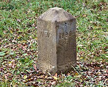
Mason and Dixon Survey Terminal Point is a historic marker located near Pentress, West Virginia, United States. Located on the boundary between Monongalia County, West Virginia and Greene County, Pennsylvania,[1] it identifies the terminal station established by Charles Mason and Jeremiah Dixon on Brown's Hill on October 19, 1767. The stone placed on Brown's Hill in 1883 in the mound of 1767, marks the westernmost point reached by Mason and Dixon in delineating the common boundaries of Pennsylvania, Maryland, Delaware, and Virginia (now West Virginia), and known as the Mason–Dixon line.[2]
It was listed on the National Register of Historic Places in 1973.[1]
See also
- Star Gazers' Stone
References
- ^ a b c "National Register Information System". National Register of Historic Places. National Park Service. July 9, 2010.
- ^ E.L. Kemp (September 1972). "National Register of Historic Places Inventory Nomination Form: Mason and Dixon Survey Terminal Point" (PDF). State of West Virginia, West Virginia Division of Culture and History, Historic Preservation. Retrieved August 20, 2011.
- v
- t
- e
- Contributing property
- Keeper of the Register
- Historic district
- History of the National Register of Historic Places
- National Park Service
- Property types

county
- Barbour
- Berkeley
- Boone
- Braxton
- Brooke
- Cabell
- Calhoun
- Clay
- Doddridge
- Fayette
- Gilmer
- Grant
- Greenbrier
- Hampshire
- Hancock
- Hardy
- Harrison
- Jackson
- Jefferson
- Kanawha
- Lewis
- Lincoln
- Logan
- Marion
- Marshall
- Mason
- McDowell
- Mercer
- Mineral
- Mingo
- Monongalia
- Monroe
- Morgan
- Nicholas
- Ohio
- Pendleton
- Pleasants
- Pocahontas
- Preston
- Putnam
- Raleigh
- Randolph
- Ritchie
- Roane
- Summers
- Taylor
- Tucker
- Tyler
- Upshur
- Wayne
- Webster
- Wetzel
- Wirt
- Wood
- Wyoming
 Category:National Register of Historic Places in West Virginia
 Portal:National Register of Historic Places


 | This article about a property in Pennsylvania on the National Register of Historic Places is a stub. You can help Wikipedia by expanding it. |
- v
- t
- e
This article about a property in Monongalia County, West Virginia on the National Register of Historic Places is a stub. You can help Wikipedia by expanding it. |
- v
- t
- e


