Mehan, Oklahoma
Census-designated place in Oklahoma, United States
36°2′41″N 96°56′33″W / 36.04472°N 96.94250°W / 36.04472; -96.94250 (2020)
74074 (Stillwater)
Mehan is an unincorporated community and census-designated place (CDP) in Payne County, Oklahoma, United States. It was first listed as a CDP prior to the 2020 census.[2]
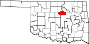
The CDP is in central Payne County, on the northeast side of the valley of Stillwater Creek, a southeast-flowing tributary of the Cimarron River. Mehan is 11 miles (18 km) southeast of Stillwater, the Payne county seat, and 10 miles (16 km) northeast of Perkins.
Demographics
| Census | Pop. | Note | %± |
|---|---|---|---|
| 2020 | 34 | — | |
| U.S. Decennial Census[3] | |||
References
- v
- t
- e
Municipalities and communities of Payne County, Oklahoma, United States
County seat: Stillwater
communities
‡This populated place also has portions in an adjacent county or counties
- Oklahoma portal
- United States portal
 | This Oklahoma state location article is a stub. You can help Wikipedia by expanding it. |
- v
- t
- e


