Menindee County
Map all coordinates using OpenStreetMap
Download coordinates as:
- KML
- GPX (all coordinates)
- GPX (primary coordinates)
- GPX (secondary coordinates)
Cadastral in New South Wales, Australia
| Menindee New South Wales | |||||||||||||||
|---|---|---|---|---|---|---|---|---|---|---|---|---|---|---|---|
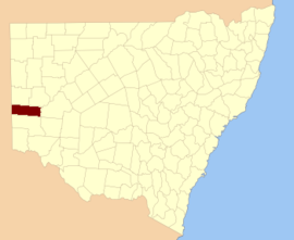 Location in New South Wales | |||||||||||||||
| |||||||||||||||
Menindee County is one of the 141 cadastral divisions of New South Wales. It is located between the Darling River and the South Australian border. Menindee is at its north-eastern edge. The Menindee Lakes are located there.
The name Menindee is of unknown origin.[1]
Parishes within this county
A full list of parishes found within this county; their current LGA and mapping coordinates to the approximate centre of each location is as follows:
| Parish | LGA | Coordinates |
|---|---|---|
| Bintullia | Unincorporated | 32°40′32″S 142°11′08″E / 32.67556°S 142.18556°E / -32.67556; 142.18556 (Bintullia) |
| Buckalow East | Unincorporated | 32°38′22″S 141°15′12″E / 32.63944°S 141.25333°E / -32.63944; 141.25333 (Buckalow East) |
| Buckalow West | Unincorporated | 32°33′51″S 141°05′00″E / 32.56417°S 141.08333°E / -32.56417; 141.08333 (Buckalow West) |
| Buckalow | Unincorporated | 32°33′35″S 141°13′43″E / 32.55972°S 141.22861°E / -32.55972; 141.22861 (Buckalow) |
| Burta | Unincorporated | 32°30′00″S 141°04′59″E / 32.50000°S 141.08306°E / -32.50000; 141.08306 (Burta) |
| Caari | Unincorporated | 32°29′07″S 141°48′34″E / 32.48528°S 141.80944°E / -32.48528; 141.80944 (Caari) |
| Cawndilla | Central Darling Shire | 32°27′28″S 142°11′24″E / 32.45778°S 142.19000°E / -32.45778; 142.19000 (Cawndilla) |
| Coonalhugga | Central Darling Shire | 32°41′36″S 142°19′44″E / 32.69333°S 142.32889°E / -32.69333; 142.32889 (Coonalhugga) |
| Coultra | Unincorporated | 32°15′35″S 141°04′04″E / 32.25972°S 141.06778°E / -32.25972; 141.06778 (Coultra) |
| Doon | Unincorporated | 32°20′27″S 141°12′56″E / 32.34083°S 141.21556°E / -32.34083; 141.21556 (Doon) |
| Enmore | Unincorporated | unknown |
| Ita | Unincorporated | 32°39′33″S 141°26′12″E / 32.65917°S 141.43667°E / -32.65917; 141.43667 (Ita) |
| Kinchega | Central Darling Shire | 32°31′07″S 142°19′39″E / 32.51861°S 142.32750°E / -32.51861; 142.32750 (Kinchega) |
| Laidley | Central Darling Shire | 32°25′10″S 142°18′07″E / 32.41944°S 142.30194°E / -32.41944; 142.30194 (Laidley) |
| Mitta | Unincorporated | 32°41′56″S 142°00′07″E / 32.69889°S 142.00194°E / -32.69889; 142.00194 (Mitta) |
| Mundybah | Unincorporated | 32°19′53″S 141°55′44″E / 32.33139°S 141.92889°E / -32.33139; 141.92889 (Mundybah) |
| Naloira | Central Darling Shire | 32°34′22″S 142°20′32″E / 32.57278°S 142.34222°E / -32.57278; 142.34222 (Naloira) |
| Nettlegoe | Unincorporated | 32°33′10″S 142°00′55″E / 32.55278°S 142.01528°E / -32.55278; 142.01528 (Nettlegoe) |
| Paringi | Unincorporated | 32°22′03″S 142°08′06″E / 32.36750°S 142.13500°E / -32.36750; 142.13500 (Paringi) |
| Perry | Central Darling Shire | 32°20′55″S 142°21′31″E / 32.34861°S 142.35861°E / -32.34861; 142.35861 (Perry) |
| Pinnelco | Central Darling Shire | 32°37′41″S 142°18′37″E / 32.62806°S 142.31028°E / -32.62806; 142.31028 (Pinnelco) |
| Putta | Unincorporated | 32°25′28″S 141°12′03″E / 32.42444°S 141.20083°E / -32.42444; 141.20083 (Putta) |
| Rantyga | Unincorporated | 32°18′09″S 141°36′13″E / 32.30250°S 141.60361°E / -32.30250; 141.60361 (Rantyga) |
| Tandou | Central Darling Shire | 32°32′32″S 142°12′05″E / 32.54222°S 142.20139°E / -32.54222; 142.20139 (Tandou) |
| Waneba | Unincorporated | 32°37′08″S 141°37′28″E / 32.61889°S 141.62444°E / -32.61889; 141.62444 (Waneba) |
| Wanga | Unincorporated | 32°26′05″S 141°18′54″E / 32.43472°S 141.31500°E / -32.43472; 141.31500 (Wanga) |
| Wendi | Unincorporated | 32°30′19″S 141°35′55″E / 32.50528°S 141.59861°E / -32.50528; 141.59861 (Wendi) |
| West Mitta | Unincorporated | 32°40′44″S 141°48′33″E / 32.67889°S 141.80917°E / -32.67889; 141.80917 (West Mitta) |
| West Wendi | Unincorporated | 32°25′59″S 141°27′09″E / 32.43306°S 141.45250°E / -32.43306; 141.45250 (West Wendi) |
References
- ^ "Menindee County". Geographical Names Register (GNR) of NSW. Geographical Names Board of New South Wales.


