Meteorological history of Hurricane Iota
 Track of Iota, according to the Saffir-Simpson scale | |
| Meteorological history | |
|---|---|
| Formed | November 13, 2020 |
| Remnant low | November 18 |
| Dissipated | November 19, 2020 |
| Category 4 major hurricane | |
| 1-minute sustained (SSHWS/NWS) | |
| Highest winds | 155 mph (250 km/h) |
| Lowest pressure | 917 mbar (hPa); 27.08 inHg |
| Overall effects | |
| Areas affected | Lesser Antilles, Puerto Rico, Hispaniola, Guyana Venezuela, Colombia, Central America, Mexico |
Part of the 2020 Atlantic hurricane season | |
Hurricane Iota was the second-most powerful November tropical cyclone on record in the Atlantic basin, behind only the 1932 Cuba hurricane. It was also the strongest and most intense hurricane of the hyperactive 2020 Atlantic hurricane season. At the end of October, a tropical wave emerged off Africa and traversed the Atlantic Ocean with little note. The system later impacted northern South America and the Lesser Antilles before becoming more organized, eventually becoming a tropical depression on November 13 over the Caribbean Sea. Initially stymied by adverse environmental conditions the system, which soon became Tropical Storm Iota, struggled to organize as it took an atypical southwest track. After developing a small, well-organized core, Iota entered a region exceptionally favorable for explosive intensification and dramatically developed. Within a 42-hour period from November 15 to 16, Iota strengthened from a tropical storm to a high-end Category 4 hurricane with peak winds of 155 mph (249 km/h). The hurricane's eyewall impacted the Colombian islands of Providencia and Santa Catalina around this time. Moving along a westward course, Iota slowly weakened and eventually made landfall in Nicaragua with winds of 145 mph (233 km/h) in nearly the same location as Hurricane Eta two weeks prior. Once inland, interaction with the region's mountainous terrain caused the system to rapidly deteriorate and its surface circulation dissipated on November 18. Its remnants persisted another day before last being noted southwest of Guatemala.
Iota bolstered records set during the 2020 Atlantic hurricane season and became one of the fastest intensifying hurricanes ever observed. Its rate of intensification in a 42-hour period was only exceeded by Hurricanes Rita and Wilma in 2005. The compounding devastation it caused just two weeks after Eta led to the retirement of the letter Iota in 2021.[nb 1] Collectively, the two hurricanes killed at least 259 people and inflicted more than $9 billion in damage.[1]
Origins

A low-latitude (below 10°N) tropical wave exited the coast of West Africa over the Atlantic Ocean on October 30, 2020. Scattered convection accompanied the wave as it moved west over open waters. On November 7–8, the wave turned northwest and traversed northern South America, crossing Guyana, Venezuela, and the Windward Islands before emerging over the Caribbean Sea.[2] Largely favorable environmental conditions ahead of the disturbance led to the National Hurricane Center (NHC) issuing outlooks for potential cyclogenesis at this time.[2][3] Turning back to the west and slowing, interaction with an upper-level trough fostered the development and expansion of convection. Strong wind shear inhibited organization as the system approached Hispaniola on November 10–11; however, the system made an unusual turn southwest in response to a mid-level ridge over the southwestern Atlantic and a surface low developed by 12:00 UTC on November 12. Lessening wind shear in this region enabled convection to concentrate around the center of the low and the system became a tropical depression, the record-tying thirty-first of the season,[4] approximately 185 mi (298 km) northwest of Aruba. The depression strengthened into Tropical Storm Iota six hours later, bolstering the already record-breaking number of named storms during the 2020 season to 30.[2][4][5]
Throughout November 13, minimal intensification occurred as Iota remained a broad system with its surface- and mid-level circulations disjointed.[2][6] Large-scale environmental conditions consisting of sea surface temperatures of 84 °F (29 °C) and ample low- to mid-level moisture favored significant intensification of the cyclone.[2] However, unexpected localized moderate shear and Iota's proximity to Colombia kept the cyclone disorganized.[7] As Iota moved farther from land on November 14, banding features became more pronounced and deep convection blossomed over a tightening circulation.[2][8]
Explosive intensification
With Iota becoming more compact and organized within the aforementioned favorable conditions and shear relaxing, the system underwent an exceptional period of explosive intensification[nb 2] from 18:00 UTC on November 14 to 12:00 UTC on November 16. The environment surrounding Iota was ideal for this to occur: wind shear fell below 5 mph (8 km/h), lower- to mid-level relative humidity values exceeded 70 percent, and SSTs averaged 84–86 °F (29–30 °C).[2][9] A symmetrical central dense overcast with temperatures averaging −112 °F (−80 °C) and broad outflow developed on November 15.[10] Data from the 53rd Weather Reconnaissance Squadron revealed Iota to have become a hurricane by 06:00 UTC that day,[2] the 14th such storm of the season. This was the second-highest number of hurricanes in a single season since reliable records began, just shy of the 15 in 2005.[11][nb 3] Iota's core wobbled northwest at the onset of this intensification as the overall trajectory shifted west in response to a strengthening ridge spanning from the western Atlantic to the Gulf of Mexico.[2][10] A ragged eye formed throughout the latter part of November 15 as the system became co-located with an upper-level anticyclone.[2][10][14]
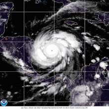
The most rapid phase of intensification occurred early on November 16 during which a 6-hour pressure drop of 26 mbar (hPa; 0.76 mbar), including a drop of 10 mbar (10 hPa; 0.30 inHg) in a single hour, was observed by aircraft reconnaissance.[2][15] The now 15 mi (24 km) wide eye featured six mesovortices,[2] intense eyewall lightning, and hail.[15] Though not fully understood, hypotheses at the time proposed that eyewall mesovortices can create intense hot towers with strong updrafts capable of more efficiently transporting mass out of the eye. This in turn hastens the rate of intensification. The mesovortices later degraded into a single, intense cell that remained in the southern eyewall through Iota's landfall in Nicaragua.[2] Between 00:00 and 06:00 UTC, Iota became a major hurricane, the record-tying seventh of the season,[nb 4] [2][5] and reached Category 4 intensity by 06:00 UTC. Around 10:45 UTC the center of Iota passed less than 5 mi (8 km) north of Providencia and Santa Catalina and its eyewall struck the islands directly. It is estimated the islands experienced sustained winds of at least 130 mph (210 km/h).[2]
The hurricane's exceptional intensification ended at 12:00 UTC on November 16 with it acquiring maximum sustained winds of 155 mph (249 km/h) and a minimum pressure of 917 mbar (917 hPa; 27.1 inHg).[2] This made Iota the second-most intense November hurricane on record, only behind the 1932 Cuba hurricane.[17] Iota's intensification was one of the fastest on record in the Atlantic basin. During the 42-hour period from 18:00 UTC on November 14 to 12:00 UTC on November 16, its central pressure fell by 80 mbar (80 hPa; 2.4 inHg) and its maximum sustained winds rose by 105 mph (169 km/h). The pressure fall in this time span was the third-greatest on record, only behind 2005's Rita (93 mbar (93 hPa; 2.7 inHg)) and Wilma (105 mbar (105 hPa; 3.1 inHg)).[2]
Operationally, Iota was classified as a Category 5 hurricane with winds of 160 mph (260 km/h) based on stepped-frequency microwave radiometer (SFMR) measurements of 165 mph (266 km/h) and aircraft flight-level winds of 169 mph (272 km/h).[2][18] This would have made it the latest such storm during a calendar year on record in the basin and the only category 5 hurricane of the season.[18] However, in post-analysis, the NHC determined the SFMR values to have a high bias as the highest observations were coupled with lower flight-level winds, a problem that had recently been discovered with other intense hurricanes. The peak SFMR value was co-located with flight-level winds of 148 mph (238 km/h) which would typically reduce to 133 mph (214 km/h) at the surface using flight-level to surface reductions. NHC meteorologists determined that breaking waves along the west side of Providencia and Santa Catalina interfered with the instrument's measurement quality. Accordingly, the peak intensity was revised downward to 155 mph (249 km/h); however, this was within the normal range of uncertainty. Meteorologists noted that research into these errors is ongoing and the peak intensity of Iota could be revised in future analysis.[2]
Landfall and dissipation
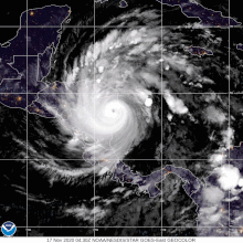
After reaching its peak strength on November 16, Iota slowly weakened on approach to Nicaragua. Lower sea surface temperatures and ocean heat content, likely the result of upwelling from Hurricane Eta, caused convection to diminish and its eye structure to deteriorate.[2][9] Around 03:40 UTC on November 17, Iota made landfall near the small village of Haulover, Nicaragua (about 25 mi (40 km) south-southwest of Bilwi) with estimated winds of 145 mph (233 km/h).[2] This was only 14 mi (23 km) south of where Hurricane Eta made landfall at a similar intensity two weeks prior.[19] In the hours leading up to the hurricane's landfall on November 17 there were no reconnaissance missions and Iota's intensity is uncertain. Furthermore, land-based measurements were nearly non-existent given the devastation wrought by Eta. An unofficial gust of 124 mph (200 km/h) was reported in southern Bilwi two hours prior to landfall while the highest reliable observations at Puerto Cabezas Airport had sustained winds of 83 mph (134 km/h) and peak gusts of 113 mph (182 km/h).[2]
Once inland, Iota rapidly weakened over the mountainous terrain of Nicaragua and Honduras.[2] Convection dramatically warmed, though the hurricane maintained a small core several hours after landfall.[20] Based on calculations using the SHIPS inland decay model, Iota is estimated to have degraded to a tropical storm by 18:00 UTC near the Nicaragua-Honduras border.[2][21] By the start of November 18, the remaining deep convection was confined to a rainband well to the northwest of the storm's core.[22] Scatterometer data indicate the system continued producing tropical storm-force winds off the northern coast of Honduras throughout the morning.[23] After weakening to a tropical depression by 12:00 UTC, the surface circulation of Iota dissipated over east-central El Salvador several hours later;[2] however, its mid-level remnant continued west and soon connected to a monsoon trough.[24][25] The system was last noted the following day well to the southwest of Guatemala. [26][27]
Notes
- ^ Although the letter Iota was formally retired from the auxiliary list of Greek letters, the list itself was discontinued following the 2020 season.[1]
- ^ The National Hurricane Center defines explosive intensification as a pressure drop of 42 mbar (42 hPa; 1.2 inHg) or greater within a 24-hour period.[2]
- ^ Operationally, Iota was considered the 13th hurricane of the season;[12] however, this was amended to 14th following the post-analysis upgrade of October's Hurricane Gamma in April 2021.[11][13]
- ^ Operationally, Iota was considered the sixth major hurricane of the season; however, this was amended to seventh following the post-analysis upgrade of October's Hurricane Zeta in May 2021.[5][16]
References
- ^ a b "WMO Hurricane Committee retires tropical cyclone names and ends the use of Greek alphabet" (Press release). World Meteorological Organization. March 17, 2021. Archived from the original on December 18, 2023. Retrieved May 21, 2021.
- ^ a b c d e f g h i j k l m n o p q r s t u v w x y z Stewart, Stacy (May 18, 2021). Hurricane Iota (AL312020) (PDF) (Report). Tropical Cyclone Report. National Hurricane Center. Retrieved May 20, 2021.
- ^ Zelinsky, David (November 8, 2020). Five-Day Graphical Tropical Weather Outlook (Report). National Hurricane Center. Retrieved May 20, 2021.
- ^ a b Mario Pedersen, Joe; Tribou, Richard; Harris, David (November 14, 2020). "Tropical Storm Iota, record 30th storm, forecast to become major hurricane". Orlando Sentinel. Retrieved May 20, 2021.
- ^ a b c Cappucci, Matthew (May 12, 2021). "2020 tied a record for the most major hurricanes in the Atlantic, after further review". The Washington Post. Retrieved May 20, 2021.
- ^ Brown, Daniel (November 13, 2020). Tropical Storm Iota Discussion Number 2 (Report). National Hurricane Center. Retrieved May 20, 2021.
- ^ Brown, Daniel (November 14, 2020). Tropical Storm Iota Discussion Number 5 (Report). National Hurricane Center. Retrieved May 20, 2021.
- ^ Brown, Daniel (November 14, 2020). Tropical Storm Iota Discussion Number 6 (Report). National Hurricane Center. Retrieved May 20, 2021.
- ^ a b Bachmeier, Scott (November 15, 2020). "Hurricane Iota in the Caribbean Sea". Cooperative Institute for Meteorological Satellite Studies. Retrieved May 21, 2021.
- ^ a b c Stewart, Stacy (November 15, 2020). Hurricane Iota Discussion Number 8 (Report). National Hurricane Center. Retrieved May 20, 2021.
- ^ a b Erdman, Jonathan (April 20, 2021). "14 Hurricanes Occurred in the 2020 Atlantic Hurricane Season After an Upgrade of Gamma, NHC Says". The Weather Channel. Retrieved May 20, 2021.
- ^ Stewart, Stacy (November 15, 2020). Hurricane Iota Intermediate Advisory Number 7A (Report). National Hurricane Center. Retrieved May 20, 2021.
- ^ Latto, Andrew (April 17, 2021). Hurricane Gamma (AL252020) (PDF) (Report). Tropical Cyclone Report. National Hurricane Center. Retrieved May 20, 2021.
- ^ Brown, Daniel (November 15, 2020). Hurricane Iota Discussion Number 10 (Report). National Hurricane Center. Retrieved May 21, 2021.
- ^ a b Stewart, Stacy (November 16, 2020). Hurricane Iota Discussion Number 12 (Report). National Hurricane Center. Retrieved May 21, 2021.
- ^ Blake, Eric; Berg, Robbie; Hagen, Andrew (May 10, 2021). Hurricane Zeta (AL282020) (PDF) (Report). Tropical Cyclone Report. National Hurricane Center. Retrieved May 20, 2021.
- ^ Sojda, Jake (November 16, 2020). "Category 5 Hurricane Iota forecast to deliver catastrophic blow to Central America". WCNC. AccuWeather. Retrieved May 21, 2021.
- ^ a b Blake, Eric (November 16, 2020). Hurricane Iota Discussion Number 13 (Report). National Hurricane Center. Retrieved May 21, 2021.
- ^ Stewart, Stacy (November 17, 2020). Hurricane Iota Discussion Number 16 (Report). National Hurricane Center. Retrieved May 21, 2021.
- ^ Blake, Eric (November 17, 2020). Hurricane Iota Discussion 17 (Report). National Hurricane Center. Retrieved May 21, 2021.
- ^ Blake, Eric (November 17, 2020). Tropical Storm Iota Discussion 18 (Report). National Hurricane Center. Retrieved May 21, 2021.
- ^ Beven, Jack (November 18, 2020). Tropical Storm Iota Discussion 19 (Report). National Hurricane Center. Retrieved May 21, 2021.
- ^ Stewart, Stacy (November 18, 2020). Tropical Depression Iota Discussion 20 (Report). National Hurricane Center. Retrieved May 21, 2021.
- ^ Pasch, Richard (November 18, 2020). Remnants Of Iota Discussion Number 21 (Report). National Hurricane Center. Retrieved May 20, 2021.
- ^ Aguirre-Echevarria, Jorge (November 18, 2020). Tropical Weather Discussion (.TXT) (Report). National Hurricane Center. Retrieved May 20, 2021.
- ^ Ramos, Nelsie (November 19, 2020). Tropical Weather Discussion (.TXT) (Report). National Hurricane Center. Retrieved May 20, 2021.
- ^ Stripling, Scott (November 20, 2020). Tropical Weather Discussion (.TXT) (Report). National Hurricane Center. Retrieved May 20, 2021.