Miary
Place in Atsimo-Andrefana, Madagascar
23°18′S 43°44′E / 23.300°S 43.733°E / -23.300; 43.733 Madagascar
 (2008)[3]
602
Miary is a rural municipality in Madagascar. It belongs to the district of Toliara II, which is a part of Atsimo-Andrefana Region. The population of the municipality was estimated to be approximately 12500 in 2008[3] of which 90% are Masikoro. The municipality has 11 fokontany (villages).
Primary and junior level secondary education are available in town. The rate of scolarization in Miary had been 70% in 2007.[4] Farming and raising livestock provides employment for 40% and 40% of the working population. The most important crops are cotton and cassava, while other important agricultural products are sugarcane and maize. Services provide employment for 20% of the population.[3]
Miary has a health center Type II (CSB II).
Geography
Miary lies on the left banks of the lower Fiherenana River, 10 km North-East of Tulear.
Sights
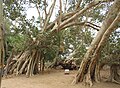
Miary is famous its sacred tree (L'arbre de Miary), a banyan which is said to be 1,700 years old.[5] It is in the eastern part of the village close to the Market Place. On the Market Place opposite the Town hall (Mairie), a market hall and an independence memorial can be visited.
-
 L'arbre de Miary
 -
 L'arbre de miary
 -
 Town hall
 -
 Market Place
 -
 Market hall


Wikimedia Commons has media related to Miary.
References
- ^ LES STRATEGIES PAYSANNES DE DEVELOPPEMENT LES STRATEGIES PAYSANNES DE DEVELOPPEMENT DANS LA COMMUNE RURALE DE MIARY
- ^ Estimated based on DEM data from Shuttle Radar Topography Mission
- ^ a b c "ILO census data". Cornell University. 2002. Retrieved 2008-03-13.
- ^ Analyse écogéographique de la végétation sectorielle du Fiherenana - Nourddine MIRHANI, 2007. Université de Toliara
- ^ Heiko Hooge: Madagaskar, p. 110. Ostfildern 2023
- v
- t
- e
Capital: Toliara

- Ambatolahy
- Andranomafana
- Ankazoabo
- Ankeriky
- Ankilivalokely
- Ántevamena
- Berenty
- Fotivolo
- Ilemby
- Tandrano
- Ambalavato
- Ankilimary
- Benenitra
- Benonoky
- Ehara
- Ianapera
- Behisatra (Behisatsy)
- Bemavo
- Beroroha
- Fanjakana
- Mandronarivo
- Marerano
- Sakena
- Tanamary
- Tanandava
- Ambatry Mitsinjo
- Ankazomanga Ouest
- Ankazombalala
- Andranomangatsiaka
- Ankilivalo
- Antohabato
- Antsavoa
- Atsimo I
- Atsimo II
- Beantake
- Beavoha
- Belamoty
- Beora
- Besely
- Betioky
- Bezaha
- Efoetsy
- Fenoandala
- Lazarivo
- Manalobe
- Masiaboay
- Maroarivo Ankazomanga
- Montifeno
- Salobe
- Savazy II
- Sakamasay
- Soamanonga
- Soaserana
- Tameantsoa
- Tanambao Ambony
- Tongobory
- Vatolatsaka
- Vohimary
9 districts; 119 communes
23°18′S 43°44′E / 23.300°S 43.733°E / -23.300; 43.733
 | This Atsimo-Andrefana location article is a stub. You can help Wikipedia by expanding it. |
- v
- t
- e


