Milford Mills, Pennsylvania
Village in Pennsylvania, United States
40°03′54″N 75°43′42″W / 40.06500°N 75.72833°W / 40.06500; -75.72833 (2000)
19335
Milford Mills was a village that was located in the Marsh Creek Valley of Chester County, Pennsylvania, United States. It was inundated by the construction of the Marsh Creek Dam in 1972.
History
Milford Mills was one of several farming villages that were settled in Upper Uwchlan Township by Welsh, Scots-Irish and English during the first quarter of the eighteenth century.[1] Like nearby Lyndell and Dorlan, Milford Mills grew during the nineteenth century as paper and textile manufacturing flourished. Later bypassed by large-scale industry, the region reverted to an agricultural economy until after World War II when the Pennsylvania Turnpike brought suburban development to northwestern Chester County.[2]
In 1961, the Pennsylvania Department of Forests and Waters selected the Marsh Creek Valley as favorable location for a flood control and drinking water reservoir to serve the Brandywine River Valley.[3] Despite protests from some residents, the Commonwealth of Pennsylvania acquired thirty-four properties throughout the region for the project, razing the village and nearby woodlands.[4][5] In 1972, the earthen Marsh Creek Dam was completed, standing at 89 feet (27 m) high and 990 feet (301 m) long.[6]
Today, the site of Milford Mills lies beneath the 530-acre (2.1 km2) Marsh Creek Lake, and is part of a water management project operated by the Chester County Water Resources Authority and the Commonwealth of Pennsylvania.
Abandoned roads and traces of houses, barns and other structures can be seen on the shores of the lake and in adjacent recreation areas in Marsh Creek State Park.
Gallery
-
 The Larkin Covered Bridge was once located in Milford Mills.
 -
 Milford Mills is currently under Marsh Creek Lake.
 -
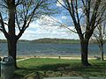
 Marsh Creek Lake where Marsh Creek Valley and Milford Mills once stood
 -
![Larkin's Covered Bridge at its original location on Covered Bridge Road [7]](//upload.wikimedia.org/wikipedia/en/thumb/b/b8/Larkin%27s_Covered_Bridge%2C_Milford_Mills%2C_Pennsylvania.jpg/120px-Larkin%27s_Covered_Bridge%2C_Milford_Mills%2C_Pennsylvania.jpg) Larkin's Covered Bridge at its original location on Covered Bridge Road [7]
Larkin's Covered Bridge at its original location on Covered Bridge Road [7] -
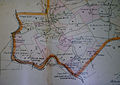 Map of Milford Mills from an 1883 Atlas
 -
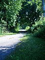 A portion of Milford Road abandoned following the construction of the Marsh Creek dam.


![Larkin's Covered Bridge at its original location on Covered Bridge Road [7]](http://upload.wikimedia.org/wikipedia/en/thumb/b/b8/Larkin%27s_Covered_Bridge%2C_Milford_Mills%2C_Pennsylvania.jpg/120px-Larkin%27s_Covered_Bridge%2C_Milford_Mills%2C_Pennsylvania.jpg)


References
- ^ "Milford Mills: A Picture of the Past that Soon May Vanish". Philadelphia Inquirer. May 12, 1963.
- ^ "Milford Mills: A Picture of the Past that Soon May Vanish". Philadelphia Inquirer. May 12, 1963.
- ^ "Long-Awaited Work Gets Underway on Marsh Creek Dam". Philadelphia Inquirer. July 12, 1970.
- ^ "Owners of Estate in Upper Uwchlan Township Fight Dam Project". Philadelphia Inquirer. March 6, 1966.
- ^ "Long-Awaited Work Gets Underway on March Creek Dam". Philadelphia Inquirer. July 12, 1970.
- ^ "Long-Awaited Work Gets Underway on Marsh Creek Dam". Philadelphia Inquirer. July 12, 1970.
- ^ "Covered Bridges". Philadelphia Inquirer. July 3, 1966.
- v
- t
- e
Municipalities and communities of Chester County, Pennsylvania, United States
County seat: West Chester

- Birmingham
- Caln
- Charlestown
- East Bradford
- East Brandywine
- East Caln
- East Coventry
- East Fallowfield
- East Goshen
- East Marlborough
- East Nantmeal
- East Nottingham
- East Pikeland
- East Vincent
- East Whiteland
- Easttown
- Elk
- Franklin
- Highland
- Honey Brook
- Kennett
- London Britain
- London Grove
- Londonderry
- Lower Oxford
- New Garden
- New London
- Newlin
- North Coventry
- Penn
- Pennsbury
- Pocopson
- Sadsbury
- Schuylkill
- South Coventry
- Thornbury
- Tredyffrin
- Upper Oxford
- Upper Uwchlan
- Uwchlan
- Valley
- Wallace
- Warwick
- West Bradford
- West Brandywine
- West Caln
- West Fallowfield
- West Goshen
- West Marlborough
- West Nantmeal
- West Nottingham
- West Pikeland
- West Sadsbury
- West Vincent
- West Whiteland
- Morstein
- Westtown
- Willistown
- Berwyn
- Caln
- Chadds Ford‡
- Chesterbrook
- Cheyney University‡
- Cochranville
- Devon
- Dilworthtown‡
- Eagle
- Eagleview
- Exton
- Frazer
- Glenmoore
- Hamorton
- Hayti
- Kenilworth
- Kimberton
- Lincoln University
- Lionville
- Marshallton
- Nottingham
- Paoli
- Pomeroy
- Pughtown
- Sadsburyville
- South Pottstown
- Thorndale
- Toughkenamon
- Unionville
- Westwood
communities
- Birchrunville
- Black Horse
- Brandamore
- Bucktown
- Byers Station
- Cedarville
- Chatham
- Chester Springs
- Chesterville
- Compass
- Coventryville
- Cromby
- Darlington Corners
- Daylesford
- Devault
- Doe Run
- Dorlan
- Embreeville
- Ercildoun
- Faggs Manor
- Glenloch
- Goshenville
- Hallman
- Harmonyville
- Hayesville
- Hephzibah
- Hickory Hill
- Hiestand
- Hinsonville
- Homeville
- Hopewell†
- Howellville
- Humphreyville
- Icedale
- Ironsides
- Isabella
- Jennersville
- Kaolin
- Kelton
- Kemblesville
- Knauertown
- Landenberg
- Lenape
- Lewisville
- London Grove
- Longwood Gardens
- Lower Hopewell
- Ludwigs Corner
- Lyndell
- Mendenhall
- Milford Mills
- Mortonville
- Nantmeal Village
- Parker Ford
- Pocopson
- Russellville
- St. Peters
- Siousca
- Springdell
- Steelville
- Strafford‡
- Strickersville
- Sugartown
- Suplee
- Valley Forge
- Wagontown
- Warwick
- Wayne‡
- West Goshen
- Whitford
- Willowdale
- Yellow Springs
‡This populated place also has portions in an adjacent county or counties †Former borough
- Pennsylvania portal
- United States portal


